Mount Golub facts for kids
Quick facts for kids Mount Golub |
|
|---|---|

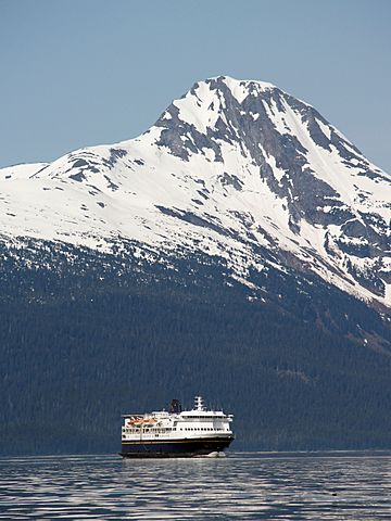
Mt. Golub and ferry
|
|
| Highest point | |
| Elevation | 4,194 ft (1,280 m) |
| Prominence | 1,594 ft (486 m) |
| Isolation | 2.17 mi (3.49 km) |
| Geography | |
| Location | Tongass National Forest Haines Borough Alaska, United States |
| Parent range | Chilkat Range Alsek Ranges Saint Elias Mountains |
| Topo map | USGS Juneau B-4 |
| Climbing | |
| First ascent | 1968 |
| Easiest route | Northeast ridge |
Mount Golub is a tall mountain peak in Alaska, United States. It stands 4,194 ft (1,280 m) high. This mountain is part of the Chilkat Range, which is a section of the larger Saint Elias Mountains. You can find Mount Golub about 29 mi (47 km) northwest of Juneau, the capital city of Alaska. It's also only 2 mi (3 km) west of Lynn Canal, a long and narrow body of water.
Even though it's not the tallest mountain, Mount Golub is very impressive because it rises steeply from the water's edge. It gains a lot of height in a short distance. The land around the mountain is managed by the Tongass National Forest, which is the largest national forest in the United States.
The mountain was officially named in 1972 by the United States Board on Geographic Names. It was named to honor Harvey Golub (1930–1971). Harvey Golub was a member of the first group of climbers to reach the top of the mountain in 1968. Other climbers in that group were Richard Folta, Delbert Carnes, and Keith Hart. Keith Hart suggested naming the mountain after Harvey Golub after Harvey sadly passed away in a plane accident in 1971.
Climate Around Mount Golub
Mount Golub has a subarctic climate. This means it has very cold, snowy winters and cool summers. The weather systems that come from the Gulf of Alaska hit the Saint Elias Mountains. This forces the air upwards, causing a lot of rain and snow to fall on the mountain. This process is called orographic lift.
During winter, temperatures can drop very low, sometimes even below −20 °C. With the wind, it can feel even colder, below −30 °C. If you want to see or climb Mount Golub, the best time to visit is usually July. The weather is most pleasant then.
 | John T. Biggers |
 | Thomas Blackshear |
 | Mark Bradford |
 | Beverly Buchanan |


