Mount Goode facts for kids
Quick facts for kids Mount Goode |
|
|---|---|

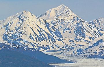
Mount Goode, west aspect
|
|
| Highest point | |
| Elevation | 10,610 ft (3,230 m) |
| Prominence | 2,160 ft (660 m) |
| Isolation | 7.57 mi (12.18 km) |
| Parent peak | Mount Marcus Baker |
| Geography | |
| Location | Chugach National Forest Valdez-Cordova Borough Alaska, United States |
| Parent range | Chugach Mountains |
| Topo map | USGS Anchorage B-3 |
| Climbing | |
| First ascent | 1966 |
| Easiest route | East Ridge (Alaska Grade 1) |
Mount Goode, pronounced like "good", is a very tall mountain in Alaska, United States. It stands about 10,610 feet (3,234 meters) high. This mountain is covered in glaciers and is part of the Chugach Mountains.
Mount Goode is located about 60 miles (97 km) east of Anchorage. It is also near College Fjord and other peaks like Mount Grace and Mount Marcus Baker. The land around Mount Goode is managed by the Chugach National Forest.
History of Mount Goode
The native Denaʼina people have their own name for this mountain. They call it Skitnu Dghelaya, which means "Brush River Mountain".
The name "Mount Goode" was officially chosen on March 5, 1924. It was named after Richard Urquhart Goode, a geographer. He worked for the United States Geological Survey, which maps the land. He was in charge of mapping the Pacific area, including Alaska, when this work first began.
The first time anyone successfully climbed to the top of Mount Goode was in April 1966. The climbers were John Vincent Hoeman and Helmut Tschaffert.
Climate Around Mount Goode
Mount Goode is in a subarctic climate zone. This means it has very long, cold, and snowy winters. The summers are usually cool.
Temperatures can drop very low, sometimes below −20 °C (−4 °F). With the wind, it can feel even colder, below −30 °C (−22 °F). This cold climate helps keep the large Knik Glacier frozen. The glacier surrounds the mountain.
The best time to climb Mount Goode is usually in May and June. The weather during these months is often the most suitable for climbing.
See also
 In Spanish: Monte Goode para niños
 | Aaron Henry |
 | T. R. M. Howard |
 | Jesse Jackson |


