Mount Madonna facts for kids
Quick facts for kids Mount Madonna |
|
|---|---|

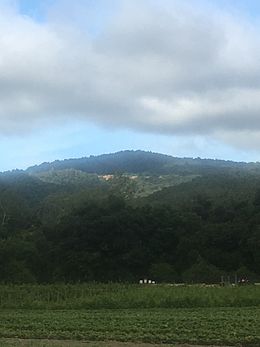
View of Mount Madonna along Watsonville Road
|
|
| Highest point | |
| Elevation | 1,900 ft (580 m) NAVD 88 |
| Prominence | 188 ft (57 m) NGVD 29 |
| Geography | |
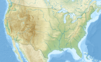
| Location | Santa Clara County, California, United States |
| Parent range | Santa Cruz Mountains |
| Topo map | USGS Mount Madonna |
Mount Madonna is a cool peak found near the southern end of the Santa Cruz Mountains in California. This famous landmark is in southwest Santa Clara County, California. You can easily see Mount Madonna from U.S. Route 101 in South Santa Clara Valley. It's also visible from California State Route 152 near Watsonville. A large county park surrounds the peak, making it a popular spot for outdoor fun!
A Bit of History
In the late 1800s, a very rich rancher named Henry Miller built his summer home here. He chose a spot close to the top of Mount Madonna. Imagine having a vacation house on a mountain!
Explore Mount Madonna County Park
Mount Madonna County Park is one of 28 amazing parks in Santa Clara County. This huge park covers about 4,605 acres! It completely surrounds the Mount Madonna peak. The east side of the park faces the Santa Clara Valley. The west side looks out towards Monterey Bay.
The park offers many fun activities for visitors. You can go hiking or horseback riding on its 14 miles of trails. There's also a special area for archery. An amphitheater is available for events and performances. If you want to spend more time, the park has places for picnics. You can even stay overnight at the campgrounds. It's one of the few parks in the area that lets you bring your dogs to the campsites!
 | John T. Biggers |
 | Thomas Blackshear |
 | Mark Bradford |
 | Beverly Buchanan |


