Mount Mageik facts for kids
Quick facts for kids Mount Mageik |
|
|---|---|

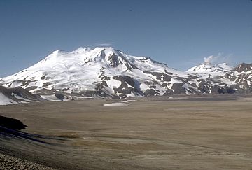
Mount Mageik (left) and Mount Martin (right)
|
|
| Highest point | |
| Elevation | 7,101 ft (2,164 m) |
| Listing | List of mountains of Alaska |
| Geography | |
| Parent range | Aleutian Range |
| Topo map | USGS Mount Katmai A-4 |
| Geology | |
| Age of rock | Pleistocene to Holocene |
| Mountain type | Stratovolcano |
| Volcanic arc | Aleutian Arc |
| Last eruption | 500 BCE ± 50 years no |
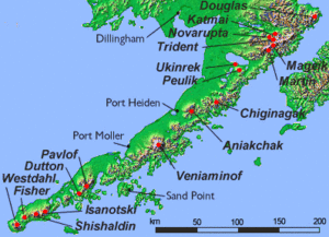
Mount Mageik is a tall, cone-shaped stratovolcano located on the Alaska Peninsula. It's a part of the Aleutian Range and is found within the Katmai National Park and Preserve in Alaska, U.S.
Scientists haven't seen Mount Mageik erupt in recent history. There was a report of an eruption in 1946, but this is now thought to be incorrect. However, the youngest rocks found on the volcano show that it was active a long time ago, between about 8750 and 500 BCE.
What Makes Mount Mageik Special?
Even though Mount Mageik isn't erupting with lava, it still shows signs of volcanic activity. On its northeast side, there's a younger crater. This crater is home to very active fumaroles. Fumaroles are vents that release superheated steam and gases from deep within the volcano. These gases often leave behind bright yellow deposits of sulfur.
The rocks that make up Mount Mageik's cones are different types of cooled lava. These include andesite, basaltic andesite, and dacite.
Ash from Other Volcanoes
Mount Mageik is covered in a layer of ash from other powerful eruptions in the area. This ash comes from two major events:
- The huge 1912 eruption of Novarupta.
- The 1953 eruption of the nearby Trident Volcano.
This shows how far volcanic ash can travel and how it can cover the landscape around volcanoes.
 | Delilah Pierce |
 | Gordon Parks |
 | Augusta Savage |
 | Charles Ethan Porter |


