Mount McDowell facts for kids
Quick facts for kids Mount McDowell |
|
|---|---|
| Red Mountain, FireRock | |

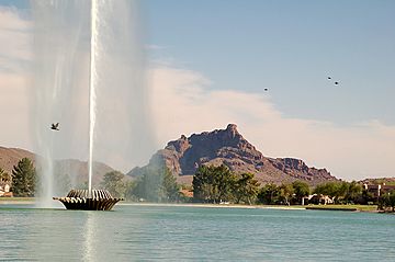
Red Mountain from Fountain Hills, Arizona
|
|
| Highest point | |
| Elevation | 2,832 ft (863 m) NAVD 88 |
| Prominence | 1,260 ft (384 m) |
| Geography | |
| Location | |
| Parent range | McDowell Mountains, Arizona |
| Topo map | USGS Granite Reef Dam |
| Geology | |
| Age of rock | Tertiary |
Mount McDowell is a well-known mountain in Arizona. People often call it Red Mountain or FireRock. It is located on the Salt River Pima-Maricopa Indian Reservation, near Mesa, Arizona. The mountain is named after General Irvin McDowell. He was an important officer during the American Civil War. Mount McDowell stands about 2,832 feet (863 meters) tall. It is not the same as McDowell Peak, which is another mountain about 11 miles away.
Contents
Why is it Called Red Mountain?
Mount McDowell is famous for its unique red color. This color comes from the type of rock it is made of. The mountain is formed from sandstone conglomerate. This rock glows with a bright red color, especially when the sun sets. That is why many people call it "Red Mountain" or "FireRock."
The Gunsight Feature
On the western side of Mount McDowell, there is a deep cut or crack. This special feature is known as "Gunsight." It looks like the narrow slot on an old fort used for aiming at enemies. You can often see this "Gunsight" in pictures of the mountain.
Visiting Mount McDowell
Mount McDowell is a very beautiful mountain to photograph. However, it is not easy to get close to it. The mountain is located on the Salt River Pima-Maricopa Indian Reservation. Since the 1980s, the community has made the mountain off-limits. This means people cannot hike, climb, or take pictures up close. This rule was put in place to protect the mountain from damage.
Best Viewing Spots
Even though you cannot go onto the mountain, you can still see it from a distance.
- The eastern side of the mountain is along Power Road and Bush Highway. There are places where you can pull your car over safely.
- There is also a picnic area just north of Granite Reef Dam. You might need a special pass called a Tonto Pass to use this area.
- The western side of the mountain is along SR 87, also known as Beeline Highway. This is a busy road, but there are a few spots where you can quickly pull off to take a look.
 | Selma Burke |
 | Pauline Powell Burns |
 | Frederick J. Brown |
 | Robert Blackburn |


