
Mount Moriah (Nevada) facts for kids
Quick facts for kids Mount Moriah |
|
|---|---|

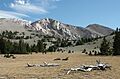
Mount Moriah, looking southwest from 'The Table,' in the Snake Range.
|
|
| Highest point | |
| Elevation | 12,072 ft (3,680 m) NAVD 88 |
| Prominence | 4,907 ft (1,496 m) |
| Listing |
|
| Geography | |

Mount Moriah
Location in Nevada
|
|
| Location | White Pine County, Nevada, U.S. |
| Parent range | Snake Range |
| Topo map | USGS Mount Moriah |
Mount Moriah is a tall mountain located in eastern Nevada, in the United States. It stands at about 12,072 feet (3,680 meters) high. This makes it the fifth-highest mountain in the entire state of Nevada! It's also one of the most noticeable peaks, ranking as the ninth-most prominent.
This impressive mountain is part of the Snake Range and is found in White Pine County. It is protected within the Mount Moriah Wilderness, which is managed by the Humboldt-Toiyabe National Forest.
Where is Mount Moriah Located?
Mount Moriah is a giant that rises over 6,000 feet (1,800 meters) from the valleys around it. To its east is the Snake Valley, and to its west is the Spring Valley. The very top of Mount Moriah is the highest point you can find in the entire Humboldt-Toiyabe National Forest.
Nearby Natural Wonders
Just north of the mountain, there's a large, flat area called The Table. This special place is home to very old Great Basin Bristlecone Pine trees. These trees are known for living for thousands of years!
The mountain is about 37 miles (60 kilometers) east of Ely, which is the closest town. Two major roads, U.S. Route 6 and U.S. Route 50, pass nearby through Sacramento Pass. This pass divides the northern and southern parts of the Snake Range. South of the pass, you can find Great Basin National Park and Wheeler Peak, another famous mountain.
Images for kids
-
Mount Moriah, looking southwest from 'The Table,' in the Snake Range.
