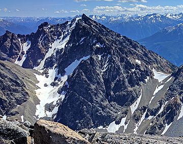
Mount Penrose facts for kids
Quick facts for kids Mount Penrose |
|
|---|---|

Mount Penrose seen from Dickson Peak
|
|
| Highest point | |
| Elevation | 2,634 m (8,642 ft) |
| Prominence | 392 m (1,286 ft) |
| Geography | |
| Parent range | Dickson Range |
| Topo map | NTS 92/J15 |
| Climbing | |
| First ascent | Boies Penrose |
Mount Penrose, also called Penrose by local people, is a tall mountain in British Columbia, Canada. It stands 2,634 m (8,642 ft) high. This mountain is the most eastern peak of the Dickson Range. The Dickson Range is part of the larger Chilcotin Ranges.
Mount Penrose is located near the town of Gold Bridge, British Columbia. It is also right above and to the west of Gun Lake. The mountain was named after Boies Penrose. He was a senator from Philadelphia, Pennsylvania. Senator Penrose was the first person known to climb the mountain. He did this during a hunting trip led by a famous guide named W.G. "Bill" Manson.
Mountain Climate
Mount Penrose has a cold climate, known as a subarctic climate. This means it has long, very cold winters and short, cool summers. Most of the weather comes from the Pacific Ocean. These weather systems travel east towards the Coast Mountains.
When the clouds hit the tall Coast Mountains, they are forced to rise higher. This process is called Orographic lift. It causes the clouds to drop a lot of their moisture. This moisture falls as rain or heavy snowfall. Because of this, the Coast Mountains get a lot of precipitation. This is especially true during the winter months, when most of it falls as snow.
Temperatures on Mount Penrose can drop very low. They can go below −20 °C. With the wind, it can feel even colder, sometimes below −30 °C. The best time to climb Mount Penrose is from July through September. The weather during these months is usually the most favorable for outdoor activities.
 | William M. Jackson |
 | Juan E. Gilbert |
 | Neil deGrasse Tyson |


