Mount Pleasant, Tennessee facts for kids
Quick facts for kids
Mount Pleasant, Tennessee
|
||
|---|---|---|

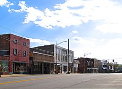
Mount Pleasant Main Street, October 2016
|
||
|
||
| Nickname(s):
The Phosphate Capital of the World
|
||

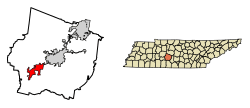
Location of Mount Pleasant in Maury County, Tennessee.
|
||
| Country | United States | |
| State | Tennessee | |
| County | Maury | |
| Government | ||
| • Type | City Manager-Commission | |
| Area | ||
| • Total | 12.60 sq mi (32.64 km2) | |
| • Land | 12.58 sq mi (32.57 km2) | |
| • Water | 0.03 sq mi (0.07 km2) | |
| Elevation | 676 ft (206 m) | |
| Population
(2020)
|
||
| • Total | 4,784 | |
| • Density | 380.38/sq mi (146.87/km2) | |
| Time zone | UTC-6 (Central (CST)) | |
| • Summer (DST) | UTC-5 (CDT) | |
| ZIP code |
38474
|
|
| Area code(s) | 931 | |
| FIPS code | 47-51080 | |
| GNIS feature ID | 1306783 | |
Mount Pleasant is a city located in Maury County, Tennessee, in the United States. It's known as the birthplace of Samuel R. Watkins, a famous writer and humorist from the 1800s. It was also once called "The Phosphate Capital of the World" because of its mining history. In 2020, about 4,784 people lived there.
Contents
A Look Back: Mount Pleasant's History
Mount Pleasant started as a small settlement in the early 1800s. More people moved there after the Military Road was built in 1817. This road connected Nashville, Tennessee, to Madisonville, Louisiana. By 1824, Mount Pleasant became a city. It had a store, a tavern, and several churches.
A big change happened in 1895. Brown phosphate rock was found in the area! This discovery led to a mining boom, meaning many mines opened. It also gave the city its special nickname. Within a few years, ten different phosphate mining companies were working in Mount Pleasant. They produced over 25,000 tons of phosphate each year. The city's population grew a lot, from 466 people in 1890 to 2,007 people in 1900. Phosphate mining was a very important part of the city's economy for many years, even into the late 1900s.
Where is Mount Pleasant?
Mount Pleasant is located at 35°32′42″N 87°11′55″W / 35.54500°N 87.19861°W. The city covers about 11.1 square miles (28.7 square kilometers) of land. Only a tiny part, about 0.04 square miles (0.1 square kilometers), is water. Mount Pleasant sits in a wide, flat area. Low hills surround it to the east, south, and west. U.S. Route 43 is a main road that connects the city to Columbia to the northeast and Lawrenceburg to the south.
Mount Pleasant's Weather
| Climate data for Mount Pleasant 1N, Tennessee (1991–2020 normals, extremes 1953–present) | |||||||||||||
|---|---|---|---|---|---|---|---|---|---|---|---|---|---|
| Month | Jan | Feb | Mar | Apr | May | Jun | Jul | Aug | Sep | Oct | Nov | Dec | Year |
| Record high °F (°C) | 76 (24) |
84 (29) |
87 (31) |
93 (34) |
99 (37) |
107 (42) |
105 (41) |
106 (41) |
105 (41) |
97 (36) |
85 (29) |
76 (24) |
107 (42) |
| Mean daily maximum °F (°C) | 47.3 (8.5) |
52.3 (11.3) |
61.3 (16.3) |
71.6 (22.0) |
79.9 (26.6) |
87.6 (30.9) |
90.5 (32.5) |
89.6 (32.0) |
83.7 (28.7) |
72.5 (22.5) |
61.2 (16.2) |
50.9 (10.5) |
70.7 (21.5) |
| Daily mean °F (°C) | 37.2 (2.9) |
41.8 (5.4) |
49.8 (9.9) |
59.5 (15.3) |
69.1 (20.6) |
77.2 (25.1) |
79.9 (26.6) |
78.0 (25.6) |
71.4 (21.9) |
59.5 (15.3) |
48.7 (9.3) |
40.6 (4.8) |
59.4 (15.2) |
| Mean daily minimum °F (°C) | 27.1 (−2.7) |
31.3 (−0.4) |
38.4 (3.6) |
47.4 (8.6) |
58.4 (14.7) |
66.7 (19.3) |
69.2 (20.7) |
66.4 (19.1) |
59.2 (15.1) |
46.6 (8.1) |
36.3 (2.4) |
30.3 (−0.9) |
48.1 (8.9) |
| Record low °F (°C) | −17 (−27) |
−8 (−22) |
5 (−15) |
20 (−7) |
31 (−1) |
38 (3) |
47 (8) |
44 (7) |
33 (1) |
23 (−5) |
9 (−13) |
−10 (−23) |
−17 (−27) |
| Average precipitation inches (mm) | 5.25 (133) |
5.14 (131) |
6.00 (152) |
5.42 (138) |
6.27 (159) |
5.40 (137) |
4.78 (121) |
3.96 (101) |
5.34 (136) |
3.89 (99) |
4.26 (108) |
6.52 (166) |
62.23 (1,581) |
| Average precipitation days (≥ 0.01 in) | 10.0 | 10.1 | 10.9 | 9.2 | 10.6 | 9.5 | 9.6 | 8.5 | 7.0 | 8.3 | 9.2 | 10.0 | 112.9 |
| Source: NOAA | |||||||||||||
People in Mount Pleasant
| Historical population | |||
|---|---|---|---|
| Census | Pop. | %± | |
| 1890 | 466 | — | |
| 1900 | 2,007 | 330.7% | |
| 1910 | 1,973 | −1.7% | |
| 1920 | 2,093 | 6.1% | |
| 1930 | 2,010 | −4.0% | |
| 1940 | 3,089 | 53.7% | |
| 1950 | 2,931 | −5.1% | |
| 1960 | 2,921 | −0.3% | |
| 1970 | 3,530 | 20.8% | |
| 1980 | 3,375 | −4.4% | |
| 1990 | 4,278 | 26.8% | |
| 2000 | 4,491 | 5.0% | |
| 2010 | 4,561 | 1.6% | |
| 2020 | 4,784 | 4.9% | |
| Sources: | |||
Who Lives Here? (2020 Census)
| Race | Number | Percentage |
|---|---|---|
| White (non-Hispanic) | 3,440 | 71.91% |
| Black or African American (non-Hispanic) | 894 | 18.69% |
| Native American | 15 | 0.31% |
| Asian | 31 | 0.65% |
| Pacific Islander | 2 | 0.04% |
| Other/Mixed | 267 | 5.58% |
| Hispanic or Latino | 135 | 2.82% |
As of the 2020 United States census, there were 4,784 people living in Mount Pleasant. These people made up 1,935 households, and 1,318 families.
Getting Around Mount Pleasant
Mount Pleasant is located on U.S. Route 43. It is also connected by State Route 243 and State Route 166.
The city also has its own airport, the Maury County Regional Airport.
For public transportation, there's the Mule Town Trolley Service. This trolley helps people travel all over Maury County. Its routes go from Mount Pleasant to Columbia and then to Spring Hill. A ride costs $1.00 each way. Riders can ask the driver to stop anywhere along the trolley's path. The South Central Tennessee Development District manages this trolley service.
See also
 In Spanish: Mount Pleasant (Tennessee) para niños
 | Sharif Bey |
 | Hale Woodruff |
 | Richmond Barthé |
 | Purvis Young |


