Maury County, Tennessee facts for kids
Quick facts for kids
Maury County
|
|||
|---|---|---|---|

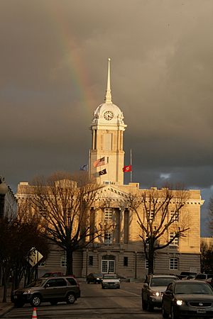
Maury County Courthouse in Columbia
|
|||
|
|||

Location within the U.S. state of Tennessee
|
|||
 Tennessee's location within the U.S. |
|||
| Country | |||
| State | |||
| Founded | 1807 | ||
| Named for | Abram Poindexter Maury, Sr. | ||
| Seat | Columbia | ||
| Area | |||
| • Total | 616 sq mi (1,600 km2) | ||
| • Land | 613 sq mi (1,590 km2) | ||
| • Water | 2.4 sq mi (6 km2) 0.4%% | ||
| Population
(2020)
|
|||
| • Total | 100,974 | ||
| • Estimate
(2023)
|
110,760 |
||
| • Density | 163.92/sq mi (63.29/km2) | ||
| Time zone | UTC−6 (Central) | ||
| • Summer (DST) | UTC−5 (CDT) | ||
| Congressional district | 5th | ||
Maury County is a county located in the state of Tennessee, in the Middle Tennessee region. In 2020, about 100,974 people lived here. Its main town, or county seat, is Columbia. Maury County is part of the larger Nashville metropolitan area.
Contents
History of Maury County
Maury County was created in 1807. It was formed from parts of Williamson County and lands that belonged to Native American tribes. The county was named after Major Abram Poindexter Maury, who was a member of the Tennessee legislature.
The soil in Maury County was very rich. This helped farming grow a lot, starting in the 1800s. The county was known for its farms. Farmers here used the labor of enslaved African Americans to grow crops like cotton and tobacco. They also raised livestock, especially dairy cattle.
Later, new machines made farming easier. This meant fewer people were needed to work on farms. Many African Americans moved to big cities in the North and Midwest for new jobs. This happened during a time called the Great Migration. Even with these changes, Maury County's population has grown since the late 1900s. Today, it leads the state in raising beef cattle.
Standing Up for Rights: The Columbia Incident of 1946
In February 1946, an important event happened in Columbia, the county seat. It was called the "Columbia Race Riot". This was a time when African Americans in Tennessee stood up to defend themselves. It was seen as a major event after World War II. Many African American veterans felt they had earned full rights as citizens after fighting in the war.
The event started when James Stephenson, an African American Navy veteran, was at a store. His mother felt she was overcharged for repairs. A white repair worker hit her. Stephenson, who was a boxer in the Navy, reacted and the worker went through a window. Stephenson and his mother were arrested. People worried they might be harmed by a large group of white people.
A local Black business owner helped get the Stephensons released and took them out of town for safety. But the crowd did not leave. About 100 Black men guarded their neighborhood, ready to resist. Police officers were attacked in the Black business district. State troopers were then sent in. They searched businesses and arrested many African Americans.
The NAACP was called for help. Many Black men were arrested and questioned without a lawyer. Two Black men died while in custody. More than 20 Black men were charged with rioting and attempted murder.
The NAACP sent Thurgood Marshall to be the main lawyer for Stephenson and the other Black men. Marshall was a very important lawyer who later became the first Black Supreme Court justice. He helped win the case Brown v. Board of Education in 1954, which said that separating public schools by race was against the law. In Columbia, Marshall helped 23 Black men get found not guilty by an all-white jury. He also won reduced sentences for others.
Geography of Maury County
Maury County covers about 616 square miles. Most of this area is land, with only a small part being water.
Neighboring Counties
- Williamson County (north)
- Marshall County (east)
- Giles County (south)
- Lawrence County (southwest)
- Lewis County (west)
- Hickman County (northwest)
Protected Natural Areas
- Natchez Trace Parkway (part)
- Duck River Complex State Natural Area
- James K. Polk Home (a state historic site)
- Stillhouse Hollow Falls State Natural Area
- Williamsport Wildlife Management Area
- Yanahli Wildlife Management Area
Population and People
| Historical population | |||
|---|---|---|---|
| Census | Pop. | %± | |
| 1810 | 10,359 | — | |
| 1820 | 22,141 | 113.7% | |
| 1830 | 27,665 | 24.9% | |
| 1840 | 28,186 | 1.9% | |
| 1850 | 29,520 | 4.7% | |
| 1860 | 32,498 | 10.1% | |
| 1870 | 36,289 | 11.7% | |
| 1880 | 39,904 | 10.0% | |
| 1890 | 38,112 | −4.5% | |
| 1900 | 42,703 | 12.0% | |
| 1910 | 40,456 | −5.3% | |
| 1920 | 35,403 | −12.5% | |
| 1930 | 34,016 | −3.9% | |
| 1940 | 40,357 | 18.6% | |
| 1950 | 40,368 | 0.0% | |
| 1960 | 41,699 | 3.3% | |
| 1970 | 43,376 | 4.0% | |
| 1980 | 51,095 | 17.8% | |
| 1990 | 54,812 | 7.3% | |
| 2000 | 69,498 | 26.8% | |
| 2010 | 80,956 | 16.5% | |
| 2020 | 100,974 | 24.7% | |
| 2023 (est.) | 110,760 | 36.8% | |
| U.S. Decennial Census 1790-1960 1900-1990 1990-2000 2010-2020 |
|||
Population in 2020
| Group | Number | Percentage |
|---|---|---|
| White (not Hispanic) | 76,182 | 75.45% |
| Black or African American (not Hispanic) | 11,241 | 11.13% |
| Native American | 248 | 0.25% |
| Asian | 934 | 0.92% |
| Pacific Islander | 45 | 0.04% |
| Other/Mixed Race | 4,664 | 4.62% |
| Hispanic or Latino | 7,660 | 7.59% |
In 2020, there were 100,974 people living in Maury County. There were 37,104 households and 25,951 families.
Population in 2010
In 2010, the county had 80,932 people. There were 33,332 households. The population density was about 132 people per square mile. Most people were White (84.4%), with 11.9% being Black or African American. About 5.8% of the population was Hispanic or Latino.
The population was spread out by age. About 26.2% were under 18 years old. Around 12% were 65 years or older. The average age was 36 years.
From 1900 to 1970, the population growth slowed down. This was partly because people moved from farms to cities for work. Also, many African Americans moved out of the South during the Great Migration. They sought better opportunities in northern cities.
Getting Around: Transportation
Interstate 65 runs through the eastern part of Maury County. It goes around Columbia and Spring Hill. Other important roads include U.S. Route 31 and U.S. Route 431. U.S. Route 43 and U.S. Route 412 also have parts in Columbia. Many state routes also cross the county.
The Maury County Airport is a public airport. It is located near Mount Pleasant and Columbia.
Learning and Schools: Education
The Maury County Public Schools district manages all the public schools in the county.
Places to Live: Communities
Cities
- Columbia (the county seat)
- Mount Pleasant
- Spring Hill (partly in Williamson County)
Census-designated place
- Summertown (mostly in Lawrence County and a small part in Lewis County)
Smaller Communities (Unincorporated)
- Ashwood
- Carters Creek
- Culleoka
- Glendale
- Fly
- Fountain Heights
- Hampshire
- Hopewell
- Mt. Joy
- Neapolis
- Santa Fe
- Sawdust
- Williamsport
div col end}}
Famous People from Maury County
- James P. Eagle (1837–1904) – He was the 16th governor of Arkansas.
- Rufus Estes (1857–1939) – A former slave who became a chef on luxury trains.
- George Rufus Kenamore (1846–1928) – A merchant and politician from Missouri.
- James K. Polk (1795–1849) – He was the 11th President of the United States.
- VanLeer Polk (1856–1907) – A Tennessee state senator and diplomat.
- Samuel R. Watkins (1839–1901) – He wrote the book Co. Aytch about his experiences in the Civil War.
See also
 In Spanish: Condado de Maury para niños
 | May Edward Chinn |
 | Rebecca Cole |
 | Alexa Canady |
 | Dorothy Lavinia Brown |


