Lewis County, Tennessee facts for kids
Quick facts for kids
Lewis County
|
|||
|---|---|---|---|
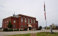
Lewis County Courthouse, April 2014
|
|||
|
|||

Location within the U.S. state of Tennessee
|
|||
 Tennessee's location within the U.S. |
|||
| Country | |||
| State | |||
| Founded | December 23, 1843 | ||
| Named for | Meriwether Lewis | ||
| Seat | Hohenwald | ||
| Largest city | Hohenwald | ||
| Area | |||
| • Total | 282 sq mi (730 km2) | ||
| • Land | 282 sq mi (730 km2) | ||
| • Water | 0.4 sq mi (1 km2) 0.1%% | ||
| Population
(2020)
|
|||
| • Total | 12,582 |
||
| • Density | 43/sq mi (17/km2) | ||
| Time zone | UTC−6 (Central) | ||
| • Summer (DST) | UTC−5 (CDT) | ||
| Congressional district | 5th | ||
Lewis County is a county found in the state of Tennessee in the United States. In 2020, about 12,582 people lived here. The main town, or county seat, is Hohenwald. The county is named after a famous explorer named Meriwether Lewis. He was part of the Lewis and Clark Expedition and passed away near Hohenwald in 1809.
Contents
History of Lewis County
Lewis County was created in 1843. It was formed from parts of five other counties: Perry, Hickman, Lawrence, Maury, and Wayne counties.
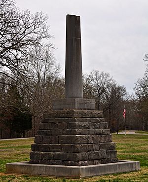
The county was named after Meriwether Lewis, a well-known explorer. His burial place is right in the middle of the county. A person named Powhatan Gordon helped create the county by suggesting the idea in the Tennessee State Senate.
In 2009, a special event took place at Lewis's grave. It was held to celebrate 200 years since his death. During this event, a statue of Lewis's head was given to the National Park Service. This group helps take care of the site where he is buried.
Geography of Lewis County
Lewis County covers a total area of about 282 square miles (730 square kilometers). Almost all of this area is land, with only a tiny bit being water.
Counties Nearby
Lewis County shares its borders with several other counties:
- Hickman County (to the north)
- Maury County (to the east)
- Lawrence County (to the south)
- Wayne County (to the southwest)
- Perry County (to the west)
Protected Natural Areas
Part of the Natchez Trace Parkway runs through Lewis County. This is a special area protected by the national government.
There are also several state-protected natural areas and wildlife management areas:
- Auntney Hollow State Natural Area
- Devil's Backbone State Natural Area
- Dry Branch State Natural Area
- Hick Hill Wildlife Management Area
- Langford Branch State Natural Area
- Laurel Hill Wildlife Management Area
- Lewis State Forest
Main Roads
These are the major highways that go through Lewis County:
 US 412
 SR 20
SR 20 SR 48
SR 48 SR 99
SR 99
People of Lewis County
| Historical population | |||
|---|---|---|---|
| Census | Pop. | %± | |
| 1850 | 4,438 | — | |
| 1860 | 2,241 | −49.5% | |
| 1870 | 1,986 | −11.4% | |
| 1880 | 2,181 | 9.8% | |
| 1890 | 2,555 | 17.1% | |
| 1900 | 4,455 | 74.4% | |
| 1910 | 6,033 | 35.4% | |
| 1920 | 5,707 | −5.4% | |
| 1930 | 5,258 | −7.9% | |
| 1940 | 5,849 | 11.2% | |
| 1950 | 6,078 | 3.9% | |
| 1960 | 6,269 | 3.1% | |
| 1970 | 6,761 | 7.8% | |
| 1980 | 9,700 | 43.5% | |
| 1990 | 9,247 | −4.7% | |
| 2000 | 11,367 | 22.9% | |
| 2010 | 12,161 | 7.0% | |
| 2020 | 12,582 | 3.5% | |
| U.S. Decennial Census 1790-1960 1900-1990 1990-2000 2010-2014 |
|||
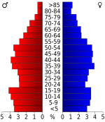
In 2020, the census showed that 12,582 people lived in Lewis County. Most of the people living in the county are White (about 91%). There are also smaller groups of African American, Native American, Asian, and Hispanic or Latino people.
Towns and Communities
City
- Hohenwald (This is the county seat, where the main government offices are.)
Census-designated place
- Summertown (Most of this area is actually in Lawrence County.)
Other Communities
- Buffalo Valley
- Gordonsburg
- Kimmins
Education
Students in Lewis County attend Lewis County High School.
See also
 In Spanish: Condado de Lewis (Tennessee) para niños
 | John T. Biggers |
 | Thomas Blackshear |
 | Mark Bradford |
 | Beverly Buchanan |


