Mount Queena facts for kids
Quick facts for kids Mount Queena |
|
|---|---|

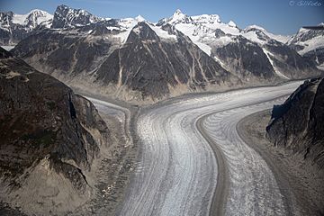
Mt. Queena (right of center) from southwest
|
|
| Highest point | |
| Elevation | 7,620+ ft (2,320+ m) |
| Prominence | 2,320 ft (710 m) |
| Isolation | 2.93 mi (4.72 km) |
| Parent peak | Mount Bressler |
| Geography | |
| Location | Tongass National Forest Juneau Borough Alaska, United States |
| Parent range | Coast Mountains Boundary Ranges Juneau Icefield |
| Topo map | USGS Juneau D-2 |
Mount Queena is a mountain in Alaska, United States. It stands tall at 7,620 feet (about 2,320 meters) above sea level. This mountain is part of the Coast Mountains and the Boundary Ranges.
Mount Queena is located on the Juneau Icefield. It is about 39 miles (63 km) north of Juneau. The mountain is also close to the border with Canada. It sits on land managed by the Tongass National Forest. Even though it's not the tallest mountain, its eastern side is very steep. It rises over 3,200 feet (975 meters) from the Gilkey Glacier in less than a mile.
Weather at Mount Queena
Mount Queena has a type of weather called a subarctic climate. This means it has very cold, snowy winters. The summers are usually cool.
Most of the weather systems start over the Pacific Ocean. They then travel east towards the Coast Mountains. When these weather systems hit the mountains, they are forced to rise. This process is called Orographic lift. As the air rises, it cools down and drops its moisture. This causes a lot of rain or snow to fall on the Coast Mountains.
Because of this, the area gets a lot of precipitation. This is especially true in winter, when heavy snow falls. Temperatures can drop very low, sometimes below -20 °C (-4 °F). With the wind, it can feel even colder, below -30 °C (-22 °F). The best time to see Mount Queena is usually in June and July. The weather is often clearer during these months.
 | May Edward Chinn |
 | Rebecca Cole |
 | Alexa Canady |
 | Dorothy Lavinia Brown |


