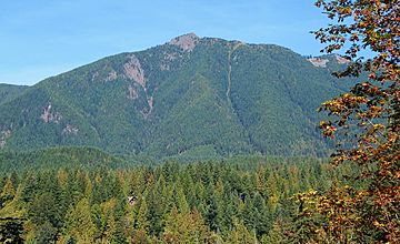
Mount Teneriffe (Washington) facts for kids
Quick facts for kids Mount Teneriffe |
|
|---|---|
 |
|
| Highest point | |
| Elevation | 4,788 ft (1,459 m) |
| Prominence | 628 ft (191 m) |
| Geography | |
| Parent range | Cascade Range |
| Topo map | USGS Mount Si |
Mount Teneriffe is a mountain found in King County, Washington state. It stands 1,459 meters (4,788 feet) tall. This mountain is on the western edge of the Cascade Range. The land around it is managed by the Mount Baker-Snoqualmie National Forest.
The closest taller peak is Green Mountain. It is about 1.9 kilometers (1.18 miles) to the northeast. Mount Teneriffe got its name from the island of Tenerife in Spain.
What is the Weather Like on Mount Teneriffe?
Mount Teneriffe is in a "marine west coast" climate zone. This means it has mild, wet winters and cool, dry summers. This type of climate is common in western North America.
Most weather systems start over the Pacific Ocean. They travel northeast towards the Cascade Range. When these weather systems reach the mountains, the peaks force the air upwards. This causes the air to cool down and drop its moisture. This moisture falls as rain or snow on the Cascades. This process is called orographic lift.
Because of this, the western side of the Cascades gets a lot of rain and snow. This is especially true during the winter months. Winters are usually cloudy. However, in summer, high pressure systems over the Pacific Ocean bring clear skies. The water that runs off Mount Teneriffe flows into streams that feed the Snoqualmie River.
How Did Mount Teneriffe Form?
The Cascade Range, where Mount Teneriffe is located, began forming millions of years ago. This was during the late Eocene Epoch. Over two million years ago, during the Pleistocene period, glaciers played a big role. These huge sheets of ice moved across the land many times. As they moved, they carved out the landscape. They also left behind piles of rock and dirt.
The last glaciers in this area started to melt about 14,000 years ago. By 10,000 years ago, they had moved north of the Canada–US border. The valleys of the rivers in this area have a U-shape. This shape was created by these recent glaciers. The mountains were also pushed up by forces inside the Earth. This pushing up, along with cracks in the Earth's crust (called faulting), and the glaciers, created the tall peaks and deep valleys we see today.
See also
 In Spanish: Mount Teneriffe (Washington) para niños


