Mount Thomas (Alaska) facts for kids
Quick facts for kids Mount Thomas |
|
|---|---|

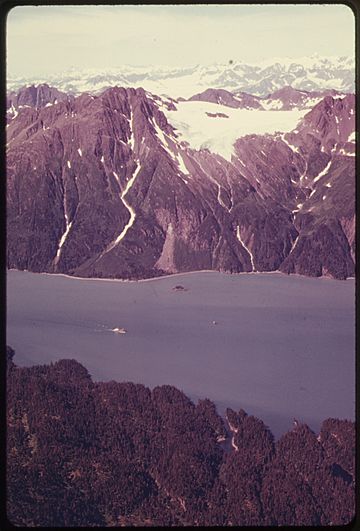
Aerial of Mt. Thomas across Valdez Narrows
|
|
| Highest point | |
| Elevation | 4,350 ft (1,330 m) |
| Prominence | 1,000 ft (300 m) |
| Isolation | 2.06 mi (3.32 km) |
| Geography | |
| Location | Valdez-Cordova Borough Alaska, United States |
| Parent range | Chugach Mountains |
| Topo map | USGS Valdez A-8 |
Mount Thomas is a mountain in Alaska, United States. It stands about 4,350 feet (1,326 meters) tall. This peak is part of the Chugach Mountains.
Mount Thomas is located about 15 miles (24 km) west-southwest of the town of Valdez, Alaska. It sits right on the edge of the Chugach National Forest. Even though it's not the tallest mountain, it looks very impressive. This is because its eastern side rises sharply from the water of Prince William Sound's Valdez Narrows. It goes from sea level to its peak in only about 1.5 miles!
The mountain got its name in 1898 from Captain William R. Abercrombie. He likely named it after General George Henry Thomas, a famous figure from history.
Understanding the Climate at Mount Thomas
Mount Thomas has a very specific type of weather. It's in a subarctic climate zone. This means the winters are long, very cold, and get a lot of snow. The summers, however, are usually mild.
The weather here is heavily influenced by the Gulf of Alaska. When weather systems move in from the Gulf, they hit the tall Chugach Mountains. The mountains force the air upwards. This process is called orographic lift. When the air rises, it cools down and drops a lot of rain and snow. This is why the area gets so much precipitation.
During winter, temperatures can drop below -20 °C (-4 °F). With the wind chill, it can feel even colder, sometimes below -30 °C (-22 °F). Because of this cold climate, there's even an unnamed glacier on the northern side of Mount Thomas.
 | Selma Burke |
 | Pauline Powell Burns |
 | Frederick J. Brown |
 | Robert Blackburn |


