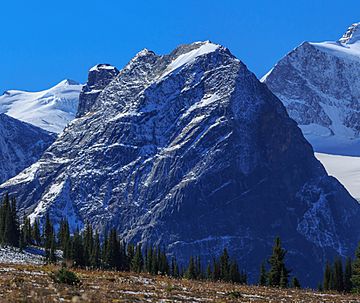
Mount Topham facts for kids
Quick facts for kids Mount Topham |
|
|---|---|

Mount Topham, north aspect
|
|
| Highest point | |
| Elevation | 2,872 m (9,423 ft) |
| Prominence | 250 m (820 ft) |
| Parent peak | Mount Dawson (3377 m) |
| Geography | |
| Location | Glacier National Park British Columbia, Canada |
| Parent range | Selkirk Mountains |
| Topo map | NTS 82N/3 |
Mount Topham is a tall mountain in Glacier National Park, British Columbia, Canada. It stands about 2,872 meters (9,423 feet) high. This mountain is part of the Selkirk Mountains range. It is quite far from cities, about 60 kilometers (37 miles) east of Revelstoke. It is also about 32 kilometers (20 miles) southwest of Golden. The mountain is near the Deville Glacier. Water from Mount Topham flows into the Beaver River.
Location and Features
Mount Topham is located in a wild and beautiful part of Canada. Its closest higher peak is Mount Selwyn, which is about 2.66 kilometers (1.65 miles) to the west. The mountain sits along the western edge of the Deville Glacier. Rain and melting snow from Mount Topham drain into the Beaver River. This river is a branch of the larger Columbia River.
How it Got its Name
Mount Topham was named in 1902 by Arthur Oliver Wheeler. He was a famous Canadian surveyor and mountaineer. Wheeler named the mountain to honor Harold Ward Topham (1857-1915). Topham was an English mountaineer. He explored and mapped parts of the Selkirk Mountains. The name of the mountain became official on September 8, 1932. This was decided by the Geographical Names Board of Canada.
Climate
Mount Topham is in a subarctic climate zone. This means it has very cold and snowy winters. The summers are usually mild. Temperatures can drop below −20 °C (−4 °F). With the wind chill, it can feel even colder, sometimes below −30 °C (−22 °F).
 | Valerie Thomas |
 | Frederick McKinley Jones |
 | George Edward Alcorn Jr. |
 | Thomas Mensah |


