
Mount Tyrwhitt facts for kids
Quick facts for kids Mount Tyrwhitt |
|
|---|---|

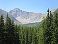
Mount Tyrwhitt's north face with Grizzly col to the left
|
|
| Highest point | |
| Elevation | 2,874 m (9,429 ft) |
| Prominence | 216 m (709 ft) |
| Geography | |

Mount Tyrwhitt
Location in British Columbia
|
|
| Location | Alberta/British Columbia, Canada |
| Parent range | Elk Range |
| Topo map | NTS 82J/10 |
| Climbing | |
| First ascent | 1915 by the Interprovincial Boundary Commission |
| Easiest route | Scramble (Moderate) |
Mount Tyrwhitt is a tall mountain located in the beautiful Canadian Rockies. It sits right on the border between two Canadian provinces, Alberta and British Columbia. This means if you stand on its peak, you're in two places at once! It is part of the Elk Range and is a popular spot for outdoor adventures.
Contents
Exploring Mount Tyrwhitt
Mount Tyrwhitt is a significant peak in the Elk Range. It is known for its stunning views and challenging climbs. The mountain is a landmark in the region.
Where is Mount Tyrwhitt Located?
This mountain is found in Canada, between Highway 40 and Elk Pass. It is west of the Highwood Pass parking lot in Kananaskis Country. You can also find it south-east of Upper Kananaskis Lake. Since it is on the Continental Divide, it marks the border between British Columbia and Alberta.
How Tall is Mount Tyrwhitt?
Mount Tyrwhitt stands at an impressive height of 2,874 meters (about 9,429 feet) above sea level. This makes it one of the notable peaks in the area. The first people to reach its summit did so in 1915. This was done by the Interprovincial Boundary Commission.
Why is it Called Mount Tyrwhitt?
The mountain was given its name in 1918. It was named after First Admiral Reginald Tyrwhitt. He was a very important officer in the Royal Navy during the First World War. Naming mountains after important people is a common way to honor them.
Images for kids
-
Mount Tyrwhitt from Kananaskis Trail

