
Mudanya facts for kids
Quick facts for kids
Mudanya
|
|
|---|---|
|
Settlement
|
|

View of Güzelyalı and Mudanya
|
|

Map showing Mudanya District in Bursa Province
|
|

Mudanya
Location in Turkey

Mudanya
Location in Marmara
|
|
| Country | Turkey |
| Province | Bursa |
| Area | 369 km2 (142 sq mi) |
| Population
(2022)
|
108,011 |
| • Density | 292.7/km2 (758.1/sq mi) |
| Time zone | TRT (UTC+3) |
| Postal code |
16940
|
| Area code | 0224 |
Mudanya is a town and district in Bursa Province, Turkey. It is located on the southern coast of the Sea of Marmara, right on the Gulf of Gemlik. Mudanya covers an area of 369 square kilometers. About 108,000 people lived there in 2022. The town is known for making olive oil. It also has a pier used by local fishing and cargo boats. From 1875 to 1948, a railway connected Mudanya with the city of Bursa.
Contents
A Look Back: Mudanya's History
Early Days and Population
In the late 1800s, Mudanya was a busy port city. Records from 1881-1893 show that about 16,683 people lived there. Most of them, around 11,792, were Ottoman Greeks. The rest, about 4,891, were Muslims.
Mudanya had a railway connection to Bursa that finished in 1875. This railway helped move goods to the seaport in Mudanya for export. Many goods, like silk, were sent from Mudanya to Istanbul.
Mudanya During the War
During the Turkish War of Independence, Mudanya faced attacks. The Royal Navy bombarded the town. This caused parts of Mudanya to burn during the Greek Summer Offensive of 1920. Sadly, Sergeant Şükrü from Mudanya and nine of his fellow soldiers died during these attacks. They were killed by the Allied bombardment and the landing of Greek troops and British Royal Marines.
.jpg)
Mudanya's Liberation
Turkish forces liberated Mudanya and its surrounding areas on September 12, 1922. The Kocaeli Army Corps, led by Halit (Karsıalan) Paşa, took control. During this time, the Greek 11th Infantry Division and its commanders were captured.
.jpg)

Mudanya is also famous for being the place where the Armistice of Mudanya was signed. This important agreement happened on October 11, 1922. It was signed between Turkey, Italy, France, and Britain. This armistice helped end the fighting after the Turkish War of Independence.
After the Treaty of Lausanne and a population exchange agreement, the Greek people living in Mudanya moved to mainland Greece. They built a new settlement there and named it Nea Moudania (meaning New Moudania). In return, many Cretan Turks came to live in Mudanya.
Mudanya's Neighborhoods
Mudanya District is made up of 47 different neighborhoods, also known as mahalle.
- Akköy
- Altıntaş
- Aydınpınar
- Bademli
- Balabancık
- Çağrışan
- Çamlık
- Çayönü
- Çekrice
- Çepni
- Çınarlı
- Dedeköy
- Dereköy
- Eğerce
- Emirleryenicesi
- Esence
- Evciler
- Göynüklü
- Güzelyalı Burgaz
- Güzelyalı Eğitim
- Güzelyalı Siteler
- Güzelyalı Yalı
- Halitpaşa
- Hançerli
- Hasanbey
- Hasköy
- İpekyayla
- Işıklı
- Kaymakoba
- Küçükyenice
- Kumyaka
- Mesudiye
- Mirzaoba
- Mürsel
- Mütareke
- Ömerbey
- Orhaniye
- Söğütpınar
- Şükrüçavuş
- Tirilye
- Ülkü
- Yalıçiftlik
- Yaman
- Yaylacık
- Yenimahalle
- Yörükali
- Yörükyenicesi
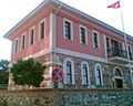
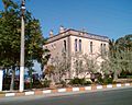
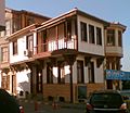
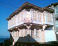
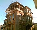
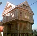
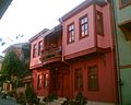
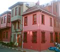
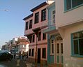
Traditional Architecture in Mudanya
Mudanya has many beautiful old buildings. These buildings show the traditional style of the Ottoman era. One famous building is where the Armistice of Mudanya was signed.
-

The Armistice of Mudanya was signed in this Ottoman era building
-
Ottoman era Governor's House in Mudanya
-
Ottoman era traditional building in Mudanya
-
Ottoman era traditional house in Mudanya
-

Ottoman era traditional house in Mudanya
-
Ottoman era traditional house in Mudanya
-
Ottoman era traditional house in Mudanya
-
Ottoman era traditional house in Mudanya
-

Ottoman era traditional houses in Mudanya
-
Ottoman era traditional houses in Mudanya
-
Ottoman era traditional houses in Mudanya
-
Ottoman era traditional houses in Mudanya


See also
 In Spanish: Mudania para niños
