Muddy River (Washington) facts for kids
Quick facts for kids Muddy River |
|
|---|---|

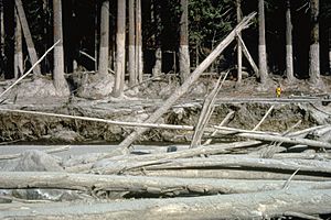
Mudline on trees showing lahar levels from 1980 volcanic eruption
|
|
|
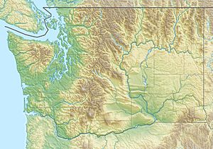
Location of the mouth of Muddy River in Washington
|
|
| Country | United States |
| State | Washington |
| County | Skamania |
| Physical characteristics | |
| Main source | southeast flank of Mount St. Helens between East Dome and Shoestring Glacier, Gifford Pinchot National Forest 5,023 ft (1,531 m) 46°11′24″N 122°09′23″W / 46.19000°N 122.15639°W |
| River mouth | Lewis River slightly upstream of Swift Reservoir 1,040 ft (320 m) 46°04′11″N 122°00′25″W / 46.06972°N 122.00694°W |
| Length | 29.8 mi (48.0 km) |
| Basin features | |
| Basin size | 351 sq mi (910 km2) |
The Muddy River is a stream about 29 miles (47 km) long in Washington, southeast of Mount St. Helens. It flows south and southeast before joining the Lewis River near the Swift Reservoir. The Lewis River then flows into the larger Columbia River. The eastern side of Mount St. Helens is part of the Muddy River's watershed, which is the area of land where all the water drains into this river.
During the big 1980 eruption of Mount St. Helens, powerful lahars swept through the Muddy River's channel. Lahars are like fast-moving rivers of mud and debris caused by volcanoes. About 135 miles (217 km) of streams around the volcano were changed by these lahars.
The United States Forest Service has a fun spot called the Muddy River Picnic Site right by the river. You can find it next to Forest Road 25 in the Gifford Pinchot National Forest. There are also trails that cross the river in its higher parts, perfect for exploring!
The River's Journey: Where the Muddy River Flows
The Muddy River starts high up on the southeast side of Mount St. Helens in the Cascade Range, at about 5,000-foot (1,500 m) elevation. The very beginning of the river is inside the Mount St. Helens National Volcanic Monument and the Gifford Pinchot National Forest. As it starts its journey, the Shoestring Glacier is to its right and East Dome is to its left.
The river flows southeast down steep slopes. Then, it makes a sharp turn to the northeast when it's about 3,000-foot (910 m) high. Here, it crosses Forest Road 83. You'll also find the Ape Canyon Trailhead and the Lava Canyon Interpretive Site nearby, both on the left side of the river. After this, the river enters a narrow area called Muddy River Gorge.
Through the Gorge and Beyond
As the Muddy River flows northeast through the gorge, it tumbles over three waterfalls! After leaving the narrow gorge, it makes another sharp turn, this time to the southeast. Here, you'll see Crane Lake on the left, and Smith Creek joins the river from the left. The Smith Creek Trailhead is on the right.
A little further downstream from the trailhead, the river leaves the national volcanic monument but stays within the national forest. At about 1,700-foot (520 m) elevation, Clearwater Creek flows into the Muddy River from the left. The river then turns south and doesn't drop as quickly. It goes under Forest Road 25, and then Clear Creek joins it from the left, about 5 miles (8 km) from where the Muddy River ends. The Muddy Creek Picnic Site is on the left side of the road crossing.
How Much Water Flows?
After Clear Creek joins, the Muddy River winds its way through an area called Cedar Flats. It leaves the national forest a little over a mile from its end. There's a special station run by the United States Geological Survey (USGS) that measures how much water is flowing in the river. This station is on the left side, about 0.5 miles (0.8 km) from where the river meets the Lewis River.
The Muddy River finally flows into the Lewis River about 60 miles (97 km) before the Lewis River reaches the Columbia River.
The USGS has been keeping track of the Muddy River's flow for many years. On average, the river flows at about 865 cubic feet per second (24.5 m3/s). The most water ever recorded flowing through the river was 25,000 cubic feet per second (710 m3/s) on February 8, 1996. This huge flow happened during a big flood in the Pacific Northwest. The lowest flow recorded was 94 cubic feet per second (2.7 m3/s) in December 1929.
A flood destroyed an older measuring station in 1974. The current station started recording data in October 1983. The massive mudflow from the 1980 Mount St. Helens eruption happened before the current station was set up.


