Muddy Run (Spruce Run tributary) facts for kids
Quick facts for kids Muddy Run |
|
|---|---|

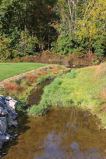
Muddy Run at its mouth, with Spruce Run visible in the background
|
|
| Physical characteristics | |
| Main source | near the base of Buffalo Mountain in West Buffalo Township, Union County, Pennsylvania between 780 and 800 feet (238 and 244 m) |
| River mouth | Spruce Run in Buffalo Township, Union County, Pennsylvania 486 ft (148 m) 40°58′47″N 76°59′02″W / 40.97969°N 76.98382°W |
| Length | 4.8 mi (7.7 km) |
| Basin features | |
| Progression | Spruce Run → Buffalo Creek → West Branch Susquehanna River → Susquehanna River → Chesapeake Bay |
| Basin size | 4.57 sq mi (11.8 km2) |
Muddy Run is a small tributary (a stream that flows into a larger one) of Spruce Run in Union County, Pennsylvania. It is about 4.8 miles (7.7 km) long. This stream flows through two areas: West Buffalo Township and Buffalo Township.
The land area that drains into Muddy Run, called its watershed, covers about 4.57 square miles (11.8 km2). Most of this area is covered by forests, but there are also many farms. Sadly, some parts of Muddy Run are not as clean as they should be. This is mainly because of dirt and mud washing into the water from farms, especially where animals graze. A bridge crosses over Muddy Run in the small community of Mazeppa.
Contents
Where Muddy Run Flows
Muddy Run starts near the bottom of Buffalo Mountain in West Buffalo Township. From there, it begins its journey, winding its way through the landscape.
The stream flows generally east and southeast, changing direction many times. It passes through West Buffalo Township before entering Buffalo Township. After flowing for a few miles, it turns southeast and then northeast. Finally, Muddy Run joins Spruce Run, which is another stream. This meeting point is about 0.34 miles (0.55 km) upstream from where Spruce Run itself ends.
Water Quality of Muddy Run
Some parts of Muddy Run's water are not as clean as they could be. About 2.6 miles (4.2 km) of the streams in its watershed are affected. The main problem is too much sediment (dirt and tiny bits of rock) and siltation (fine mud) in the water. This often comes from farms where animals graze.
Besides sediment, Muddy Run also has issues with certain bacteria like E. coli. There's also nutrient pollution (too many nutrients like nitrogen and phosphorus, often from fertilizers). Sometimes, the water temperature can also be a problem.
Scientists have studied the amount of pollution in Muddy Run. For example, the amount of sediment has been measured. There are plans to reduce these pollutants in the future. This would make the water much healthier for plants and animals.
Land Around the Stream
The land around Muddy Run, its watershed, covers about 4.57 square miles (11.8 km2). The stream's mouth (where it joins Spruce Run) is in an area called the Lewisburg USGS quadrangle. However, its source (where it begins) is in the Mifflinburg quadrangle.
About 57 percent of the land in Muddy Run's watershed is covered by forests. Another 35 percent is agricultural land, meaning it's used for farming. A small part, about 3 percent, is covered by paved surfaces like roads.
To help protect the stream, some areas along its banks have riparian buffers. These are strips of trees and plants that grow along the stream. They help filter out pollution and prevent soil from washing into the water.
History of Muddy Run
Muddy Run was officially named and added to the Geographic Names Information System on August 2, 1979. This system helps keep track of names and locations for geographic features in the United States.
A concrete bridge was built over Muddy Run in the community of Mazeppa way back in 1932. This bridge carries State Route 1001 and is 24 feet (7.3 m) long. It has been helping people cross the stream for many years!
 | Isaac Myers |
 | D. Hamilton Jackson |
 | A. Philip Randolph |


