
Mullaghcarn facts for kids
Quick facts for kids Mullaghcarn |
|
|---|---|
| Mullach Cairn | |

Near the summit of Mullaghcarn
|
|
| Highest point | |
| Elevation | 542 m (1,778 ft) |
| Listing | Marilyn |
| Naming | |
| English translation | peak of the cairns |
| Language of name | Irish |
| Geography | |

Location in Northern Ireland
|
|
| Location | County Tyrone, Northern Ireland |
| Parent range | Sperrins |
| OSI/OSNI grid | H5180 |
| Topo map | OSNI Discoverer 13 |
Mullaghcarn is a mountain located in County Tyrone, Northern Ireland. It's part of the beautiful Sperrins mountain range. The name Mullaghcarn comes from the Irish language, meaning "peak of the cairns." A cairn is a pile of stones, often used as a landmark or memorial.
This mountain reaches a height of 542 meters (about 1,778 feet). This makes it one of the taller peaks in Ireland. Mullaghcarn is found within the Fermanagh and Omagh District Council area. It sits right on the edge of Gortin Glen Forest Park. It's also the most southerly (southernmost) peak in the Sperrins. You can find it about 5 kilometers (3 miles) northeast of Omagh and 3.1 kilometers (1.9 miles) south of Gortin.
Contents
Exploring Mullaghcarn's Nature
Plant Life on the Mountain
Mullaghcarn is a steep mountain with a rocky top. On the western side, you'll find many conifer trees. These are trees that stay green all year, like pines and spruces.
The most common type of plant life on Mullaghcarn is "acid" grassland. This means the soil is acidic, which certain grasses prefer. Peat, which is a type of soil made from decaying plants, is not very common here. This is because the eastern part of the mountain has been drained. On the northern slopes, you'll see a lot of heather, a pretty purple flowering plant.
Animals of Mullaghcarn
If you explore the heathland around Mullaghcarn, you might spot a special bird called the red grouse. Heathland is an open area with low-growing plants like heather. The red grouse is well-known for its reddish-brown feathers.
Mullaghcarn's History
During World War II, Mullaghcarn played a role in training. The mountain was home to firing ranges. These ranges were used by police forces and soldiers from the United States Army. They practiced shooting and military exercises in this area.
Gallery
-
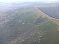
The summit of Mullaghcarn from above
-
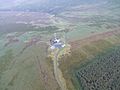
The summit of Mullaghcarn from above
-
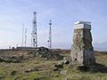
Looking east from summit, towards the cairn, two telecommunications masts and helipad


