
Mundaring Weir facts for kids

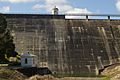
Mundaring Weir is a large concrete dam located about 39 kilometers (24 miles) from Perth, Western Australia. It sits in a hilly area called the Darling Scarp. This dam and the lake it creates form the border between the suburbs of Reservoir and Sawyers Valley. The dam holds back the waters of the Helena River.
Contents
Building the Mundaring Weir
Quick facts for kids Lake C.Y. O'ConnorHelena River Reservoir |
|
|---|---|
 |
|

Lake C.Y. O'Connor
Helena River Reservoir Location in Western Australia
|
|
| Location | Mundaring, Western Australia |
| Coordinates | 31°59′S 116°12′E / 31.983°S 116.200°E |
| Type | reservoir |
| Primary inflows | Helena River |
| Primary outflows | Helena River |
| Basin countries | Australia |
| Surface area | 6.76 km2 (2.61 sq mi) |
A soldier named Robert Dale was the first European to explore this area in 1829. Not many people lived here until the dam was built in the late 1890s. To help with construction, a special railway line was built from Mundaring to the dam site.
An amazing engineer from Ireland, C. Y. O'Connor, designed a huge project. This project would transport water all the way to the Eastern Goldfields of Coolgardie and Kalgoorlie. These towns were far away in the eastern part of Western Australia. The dam was finished in 1903.
The lake created by the dam was first called the Helena River Reservoir. In 2004, it was renamed Lake C.Y. O'Connor to honor the engineer. The company that owns the dam, the Water Corporation, sometimes calls it Mundaring Dam. However, other official groups still use the name Mundaring Weir. The local council, the Shire of Mundaring, even has an image of the weir in its logo.
Work began to make the dam taller in the late 1940s. This project was completed in November 1951. In the early 1970s, another dam, the Lower Helena Pumpback Dam, was built downstream. The Mundaring Weir last overflowed into the Helena Valley in 1996.
When the Dam Overflows
For the first 50 years, the dam overflowing was a common sight. When the weir was made taller in the 1950s, it affected how often it overflowed, but it still happened. In the 1960s, the weir regularly overflowed.
-
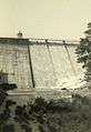
The dam overflowing in 1965

Keeping an Eye on the Dam
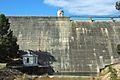
Like any old structure, Mundaring Weir needs to be checked regularly. It also needs repairs and maintenance. The original dam had a small building in the middle. This building was used to check the dam's inside condition. When the dam was made taller, this building was rebuilt. However, it was no longer used for its first purpose.
In 2009, two new entry points were made on the dam's face. These points help workers get into tunnels to monitor the dam. The weir does have some leaks. The pictures below show consistent wet spots where water moves through the structure.
-
A wet spot on the dam in 2008
-
The same spot in 2010
-
The spot in 2020


Modern Upgrades (2010–2014)
A new pump station started working in March 2014. It can pump a lot of water, up to 165,000 cubic meters (about 43.6 million gallons) per day. It can even pump up to 240,000 cubic meters (about 63.4 million gallons) per day if needed. The older pump stations and water treatment areas were then closed down.
New facilities were added to treat the water. This included cleaning, filtering, and adding chlorine and fluoride. The old facilities could not keep up with the growing demand for water. Also, they couldn't meet the latest Australian drinking water rules. Over the years, the water's color, taste, and smell had become worse. The new upgrades fixed these issues.
The Mundaring Weir Railway
The Mundaring Weir was the end point of the Mundaring Weir Branch Railway. This railway was first built by the Public Works Department of WA. It was used to transport building materials for the dam.
After the dam was finished, the area became very popular. People from Perth loved to visit for picnics and sightseeing. The project had really captured the public's interest.
The beautiful gardens around the weir and the lower "zig-zag" part of the railway line were often seen on postcards. These postcards showed many weekend and special picnic trains. These trains traveled to the weir from the 1910s until the late 1940s. You can still see the zig-zag section when the dam's water level is low (below about 35%).
The railway line was very steep. This made it hard for the trains to carry many picnic-goers. Special Garratt locomotives were best for this steep track. However, there weren't always enough of them, especially when the weir was overflowing in the 1940s. The railway line finally closed in 1952.
There was also a tramway built using timber rails. It carried cut timber from a mill about 3 miles (4.8 km) away to the weir. From there, the timber was loaded onto the main railway line. This tramway opened in 1909 and closed in 1913.
Things to Do at the Weir

The old "Pumping Station Number 1" is now a museum. It's called the C Y O'Connor Museum and is run by the National Trust. There's also the Kookaburra outdoor cinema. The Department of Environment and Conservation has a Hills Forest activity center here, too.
In the past, the water authority had houses for its workers at the weir. Now, there is a youth hostel, which was built where the old primary school used to be. You can also find an art gallery and many great spots for picnics. There are still homes for park rangers at the site. The pumping stations and water treatment facilities are still working today.
The Bibbulmun Track
The Bibbulmun Track is a very long walking trail, about 963 kilometers (598 miles) long. It starts in Kalamunda and follows Piesse Brook. Then it goes along the south side of the Helena Valley. The track crosses the weir wall and then follows the northern side of Lake C.Y. O'Connor. After that, it turns south and continues all the way to Albany.
The Golden Pipeline Project


The history of the entire Goldfields Water Supply Scheme was celebrated by the Golden Pipeline project. The Water Corporation worked with the National Trust of Australia (WA) on this. They created guide books, walking trails, and websites to share information about the scheme's history. Most of this project was developed between 2001 and 2003.
