
Mutare facts for kids
Quick facts for kids
Mutare
Umtali
|
|||
|---|---|---|---|
|
City
|
|||

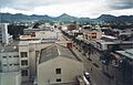
Aerial view of Central Mutare (October 2001)
|
|||
|
|||
| Nickname(s):
Gateway to the Eastern Highlands, Zimbabwe's Gateway to the Sea
|
|||
| Motto(s):
Justice and Freedom
|
|||

Mutare
Location in Zimbabwe
|
|||
| Country | |||
| Province | Manicaland | ||
| District | Mutare | ||
| Founded | 1897 | ||
| Incorporated (town) | 11 June 1914 | ||
| Incorporated (city) | 1971 | ||
| Government | |||
| • Type | Mayor–council | ||
| Area | |||
| • Urban | 191.2 km2 (73.8 sq mi) | ||
| Elevation | 1,120 m (3,675 ft) | ||
| Population
(2022 census)
|
|||
| • Urban | 224,802 | ||
| • Urban density | 1,175.74/km2 (3,045.2/sq mi) | ||
| • Metro | 500,000 | ||
| estimated | |||
| Time zone | UTC+2 (CAT) | ||
| Climate | Cwa | ||
| Website | City of Mutare | ||


Mutare, once called Umtali until 1982, is a major city in Zimbabwe. It is the capital of the Manicaland Province and the third-largest city in the country. In 2022, about 224,802 people lived in its urban area. If you include the nearby districts, the total population is over 500,000 people.
Mutare is very important for trade because it is close to the border with Mozambique. It has been a busy trading spot for a long time. The city is a key link for railways, pipelines, and highways. These connect the coast to Harare, Zimbabwe's capital, and other parts of the country. Mutare is also known for industries like timber, paper making, and food processing. It is often called the "Gateway to the Eastern Highlands" because it leads to beautiful mountains and parks.
Contents
History of Mutare: A Trading Hub

Even though Mutare was officially founded in the late 1800s, this area has a much older history. For centuries, traders traveled through here on their way to the Indian Ocean. They went from ports like Sofala to inland places like Great Zimbabwe.
Zimbabwe is famous for its soapstone carvings. These carvings show that trade routes existed here a long time ago. Some carvings found near Mutare date back to around 900 AD. These figures, some looking like people and some like animals, might have been special offerings.
Mutare began as a fort in 1897. It was built about 8 kilometers (5 miles) from the border with Mozambique. This location is only 290 kilometers (180 miles) from the Mozambican port of Beira. This is why Mutare is called "Zimbabwe's Gateway to the Sea." Locals also call it 'Kumakomoyo', meaning 'place of many mountains'.
The name Mutare comes from the word 'Utare', which means iron or possibly gold. Gold was found in the Penhalonga valley, where the Mutare River flows.
The city's location changed a few times. In 1891, it moved to a place now called Old Mutare. Then, in 1896, it moved again to be closer to the new railway line between Beira and Bulawayo. The town became a municipality in 1914 and a city in 1971. Its name officially changed from Umtali to Mutare in 1982.
Geography and Natural Beauty
Mutare is located between the Bvumba Mountains to the south and the Imbeza Valley to the north. When you approach the city from the west, you pass through Christmas Pass. This pass was named by early settlers who camped there on Christmas Day in 1890.
The city has several interesting places to visit. These include the Mutare Museum and the National Gallery of Zimbabwe. You can also see Murahwa Hill, which has ancient rock paintings. Cross Kopje has a memorial for those who died in World War I. There are also nature reserves like Cecil Kopje and Tigers Kloof.
Mutare has good transport links. Trains connect it to Harare for both passengers and goods. There are also small airports for light aircraft. The main airport for bigger flights is in Harare, about 214 kilometers (133 miles) away.
Mutare's Climate: Mild and Pleasant
Mutare has a mild climate, even though it's in a subtropical area. This is because of its higher altitude. The city often experiences light rain throughout the year. The average temperature is 19 °C (66 °F).
July is the coldest month, with temperatures between 6 °C (43 °F) and 20 °C (68 °F). October is the hottest, with temperatures from 16 °C (61 °F) to 32 °C (90 °F). The city gets about 818 mm (32 inches) of rain each year. Most rain falls from December to February.
Mutare's climate is also affected by its closeness to the ocean. This brings warm to hot summers and mild winters. Winters are not very frosty. Spring can have changing weather, but from March to June, it's usually calm and mild. Summer temperatures can reach 30 °C (86 °F).
| Climate data for Mutare | |||||||||||||
|---|---|---|---|---|---|---|---|---|---|---|---|---|---|
| Month | Jan | Feb | Mar | Apr | May | Jun | Jul | Aug | Sep | Oct | Nov | Dec | Year |
| Mean daily maximum °C (°F) | 27.6 (81.7) |
26.8 (80.2) |
26.3 (79.3) |
25.2 (77.4) |
23.7 (74.7) |
21.4 (70.5) |
21.2 (70.2) |
23.2 (73.8) |
26.1 (79.0) |
27.0 (80.6) |
27.5 (81.5) |
27.1 (80.8) |
25.3 (77.5) |
| Mean daily minimum °C (°F) | 17.5 (63.5) |
16.3 (61.3) |
15.6 (60.1) |
13.9 (57.0) |
10.6 (51.1) |
8.0 (46.4) |
7.6 (45.7) |
9.3 (48.7) |
12.2 (54.0) |
14.6 (58.3) |
16.1 (61.0) |
16.9 (62.4) |
13.2 (55.8) |
| Average rainfall mm (inches) | 153.5 (6.04) |
164.5 (6.48) |
88.4 (3.48) |
31.8 (1.25) |
12.4 (0.49) |
8.9 (0.35) |
5.8 (0.23) |
6.0 (0.24) |
20.2 (0.80) |
45.9 (1.81) |
86.4 (3.40) |
167.0 (6.57) |
790.8 (31.13) |
| Average rainy days | 13 | 11 | 10 | 4 | 3 | 2 | 2 | 2 | 2 | 5 | 8 | 12 | 74 |
| Source: World Meteorological Organization | |||||||||||||
People of Mutare
Mutare racial makeup, 1965 Black (78.48%) White (19.78%) Asian (1.22%) Coloured (.74%)
| Historical population | ||
|---|---|---|
| Year | Pop. | ±% |
| 1936 | 3,566 | — |
| 1941 | 4,812 | +34.9% |
| 1951 | 10,900 | +126.5% |
| 1965 | 46,000 | +322.0% |
| 1974 | 48,000 | +4.3% |
| 1982 | 69,621 | +45.0% |
| 1992 | 131,367 | +88.7% |
| 2002 | 170,466 | +29.8% |
| 2012 | 260,567 | +52.9% |
| 2022 | 224,802 | −13.7% |
In 1965, Mutare had a population of 46,000 people. Most of the people living in Mutare are Shona, and many speak the Manyika dialect. People from the Manyika group are sometimes called Samanyika.
According to the 2012 census, Mutare had a population of 260,567. This shows a big increase from 69,621 people in 1982.
City Layout and Neighborhoods


Mutare has different types of neighborhoods based on how many people live there. These are called low-density, medium-density, and high-density areas. In the past, people from different backgrounds lived in separate areas.
- Low-density suburbs are the most upscale areas. These include Murambi, Fairbridge Park, and Morningside. They are found in the north and east of the city.
- Medium-density suburbs are for middle-class families. Yeovil and Westlea are examples. Westlea has streets named after cities in Australia and New Zealand.
- High-density suburbs are where most people live. Sakubva is a large working-class area with nearly half of the city's population. Dangamvura is another big high-density suburb.
South of the city, you can find the beautiful Vumba Mountain range. This area has amazing natural beauty, forests, and places like the Leopard Rock Hotel. It's also known for its large pine and wattle tree plantations.
Here are some of the main neighborhoods in Mutare:
| Region | Suburbs |
|---|---|
| Northern (North of the railway line) | Murambi; Fairbridge Park; Morningside; Tiger's Kloof; Palmerston; Avenues; Utopia; Darlington; Greenside; Greenside Extension, Yeovil; Westlea; Florida; Toronto; Bordervale; Chikanga. |
| Southern (South of the railway line) | Sakubva; Dangamvura; St Josephs Park-Chikanga Extension, Weirmouth; Fern Valley; Zimunya; Hobhouse (1,2,3) extension; Natview Park, Garikai. |
City Infrastructure and Services
Mutare has an important railway station that connects to Beira and Bulawayo. The city generally tries to keep its streets clean. Many roads in older parts of the city were once paved.
Most buildings in Mutare are not very tall, with the highest being 8 floors. The city has many shops for groceries and hardware. There are also shopping centers in all suburbs, including a large mall in Dangamvura.
For healthcare, Mutare has clinics in all suburbs, a main General Hospital, and maternity hospitals. The city has good basic services that are always being improved.
Getting Around Mutare: Transportation
Mutare is well-connected by several roads. The A3 motorway goes inland towards Harare, passing through Rusape and Marondera. The A9 road goes south into the Eastern Highlands. To the east, the EN9 connects Mutare to Chimoio and the coastal city of Beira. This road is often busy because it's a main route to the sea for Zimbabwe.
Buses are a popular way to travel, both within the city and to nearby towns and villages. You can also find good quality intercity buses to Harare and Beira.
Mutare has a small airport for light aircraft and chartered flights. The closest international airport is in Harare. The National Railways of Zimbabwe offers overnight train service from Harare to Mutare a few times a week.
Mutare's Economy and Industries
The main activities in Mutare are farming (like forestry, dairy, and growing plants), mining, and manufacturing. The city's name, Mutare, comes from "metal" (Utare), possibly because gold was melted here centuries ago.
Mining includes gold at Redwing Mine and diamonds in Marange. There are also many forestry companies that produce timber, wattle bark, and charcoal. Some of the main trees grown are pine and sydney blue gum.
Mutare is home to large food producers like Cairns Foods and Tanganda Tea. There are also new manufacturing companies, such as Willowton, which makes cooking oils. Quest, a company in Mutare, assembles buses, trucks, and other vehicles.
The city has many retail stores, fuel stations, and computer shops. Many freight companies operate here, helping to move goods. Banks like Stanbic Bank, CBZ, and Nedbank also have branches in Mutare.
The Mutare City Council headquarters, called Civic Center, handles licenses and city planning. Mutare needs a bigger airport to help tourism grow. It also needs better roads, more shopping malls, and improved public spaces.
Learning in Mutare: Schools and Colleges
Mutare has many schools and colleges for students of all ages.
Primary Schools
- Baring Primary School
- Chancellor Junior School
- Chikanga Primary School
- Cross Kopje Junior School
- Dangamvura Primary School
- Hillcrest Preparatory School (Private)
- Mutare Junior School
- New Dangare Primary School
- Rujeko Primary School
- Sakubva Primary School
- St Joseph's Primary School
- Sacred Heart Primary School
Secondary Schools
- Hartzell High School
- Chikanga Secondary School
- Dangamvura High School
- Elise Gledhill High School
- Hillcrest College (Private)
- Mutare Boys' High School
- Mutare Girls' High School
- Nyamauru High School
- Sakubva High School
- St Dominic's High School
- St Joseph's High School
Colleges and Universities
- Africa University, a large university with about 5,000 students
- Marymount Teachers' College
- Mutare Teachers College
- Mutare Polytechnic
- Manicaland State University of Applied Sciences
- Zimbabwe College of Forestry
Famous People from Mutare
Many notable people have connections to Mutare:
- Washington Arubi - a professional footballer
- Onismor Bhasera - a professional footballer
- Herbert Chitepo - Zimbabwe's first black lawyer and a political leader
- Mario Frangoulis - a Greek classical singer
- Willard Katsande - a professional footballer
- Donal Lamont - a Catholic bishop who spoke out against the government
- Blessing Makunike - a professional footballer
- Chiwoniso Maraire - a famous Mbira player and singer
- Tino Mawoyo - a Zimbabwean cricketer
- Lawrence Mudehwe - the first independent Executive Mayor of Mutare
- Arthur Mutambara - a former Deputy Prime Minister of Zimbabwe
- Bishop Abel Tendekayi Muzorewa - a former prime minister
- Morgan Tsvangirai - a former Prime Minister and opposition leader
Images for kids
-
Aerial view of Central Mutare (October 2001)
-
Flag of Mutare
-

Mutare Coat of Arms
-
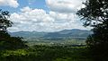
Greater Mutare as viewed from Christmas Pass
-
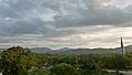
Mutare East
-
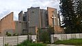
Mutare Catholic Church
See also
 In Spanish: Mutare para niños
