Mynydd Drws-y-Coed facts for kids
Quick facts for kids Mynydd Drws-y-Coed |
|
|---|---|

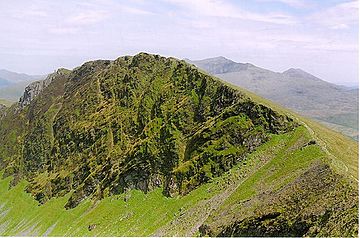
Mynydd Drws-y-Coed from Trum y Ddysgl
|
|
| Highest point | |
| Elevation | 695 m (2,280 ft) |
| Prominence | 57 m (187 ft) |
| Listing | Hewitt, Nuttall |
| Naming | |
| Language of name | Welsh |
| Geography | |
| Location | Gwynedd, Wales |
| Parent range | Moel Hebog |
| Topo map | OS Landranger 115, OS Outdoor Leisure 17 |
| Climbing | |
| Easiest route | Walk, Scramble |
Mynydd Drws-y-Coed is a mountain peak in the amazing Snowdonia National Park, located in north Wales. It is part of a famous line of mountains called the Nantlle Ridge. This peak is found at the eastern end of the ridge. It is also a smaller peak connected to a larger one nearby, called Trum y Ddysgl.
About Mynydd Drws-y-Coed
Mynydd Drws-y-Coed stands at 695 meters (about 2,280 feet) tall. It has very steep cliffs on its south side. The very top of the mountain is the highest point on a narrow, thin ridge. This means the path along the top can be quite exciting!
Exploring the Mountain
The western side of Mynydd Drws-y-Coed is very rocky and open to the air. To reach the top, you might need to do some scrambling. Scrambling is like climbing using both your hands and feet, but it's not as difficult as rock climbing.
Some parts of the path are very exposed, meaning there's not much cover and you can see a long way down. Because of this, it's good to be comfortable with heights if you plan to explore this area.
Location and Scenery
Mynydd Drws-y-Coed is located in Gwynedd, a county in Wales. It is part of the Moel Hebog mountain range within Snowdonia. The views from the top are incredible, looking out over the beautiful Welsh landscape.
 | Georgia Louise Harris Brown |
 | Julian Abele |
 | Norma Merrick Sklarek |
 | William Sidney Pittman |

