Nadina Mountain facts for kids
Quick facts for kids Nadina Mountain |
|
|---|---|

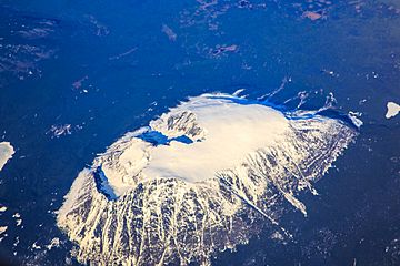
Nadina Mountain, aerial view
|
|
| Highest point | |
| Elevation | 2,111 m (6,926 ft) |
| Prominence | 592 m (1,942 ft) |
| Parent peak | Sibola Peak (2177 m) |
| Geography | |
| Location | Range 5 Coast Land District British Columbia, Canada |
| Parent range | Nechako Plateau |
| Topo map | NTS 93L/2 |
| Geology | |
| Mountain type | Intrusive |
| Type of rock | Granitic |
| Climbing | |
| Easiest route | Primitive trail, couloir scramble |
Nadina Mountain is a tall mountain in northern British Columbia, Canada. It stands about 2,111 meters (6,926 feet) high. This mountain is made of granite, which is a type of rock that forms when hot, melted rock cools slowly underground. Nadina Mountain was once part of a volcano.
The mountain is found inside Nadina Mountain Provincial Park, about 30 kilometers (19 miles) south of Houston, British Columbia. It rises sharply, about 700 meters (2,300 feet), above the lower hills around it. It's the third highest peak in the Nechako Plateau area. Nadina Mountain looks very striking because it stands out so much from the land around it.
Scientists think that during the last Ice Age, when huge glaciers covered much of the Earth, Nadina Mountain might have been a "refugia." This means it was a place where plants and animals could survive because it wasn't completely covered by ice.
The top of the mountain has many different types of lichen, which are like mossy growths. However, not many other plants grow there because the soil is poor and rocky. Below the treeline, you'll mostly find subalpine fir trees.
Nadina Mountain became a provincial park in 2008. This was mainly to protect the wildlife that lives there, especially mountain goats. The park covers an area of 2,789 hectares (about 6,892 acres). Water from Nadina Mountain flows into rivers that eventually join the Fraser River. The climate around Nadina Mountain has cold winters and mild summers. Temperatures can drop very low, sometimes below −20 °C (−4 °F).
History of Nadina Mountain
Nadina Mountain is located in the traditional lands of the Wetʼsuwetʼen First Nations people. First Nations are the original peoples of Canada. The Wet’suwet’en people would visit this mountain to hunt animals like caribou, marmots, and mountain goats.
The mountain first appeared on a map in 1879. It was labeled "Na-di-na Mtn" by George Mercer Dawson, who worked for the Geological Survey of Canada. The name "Na-di-na" comes from the Babine-Witsuwitʼen language, which is spoken by some local First Nations groups. In their language, "Na-di-na" means "standing up alone." This name perfectly describes how the mountain stands out by itself.
The name "Nadina Mountain" was officially recognized on October 6, 1936, by the Geographical Names Board of Canada. The nearby Nadina River also got its name from the mountain.
 | Isaac Myers |
 | D. Hamilton Jackson |
 | A. Philip Randolph |


