Nassawadox, Virginia facts for kids
Quick facts for kids
Nassawadox, Virginia
|
|
|---|---|
 |
|

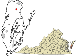
Location in Northampton County and the state of Virginia.
|
|
| Country | United States |
| State | Virginia |
| County | Northampton |
| Area | |
| • Total | 0.66 sq mi (1.72 km2) |
| • Land | 0.66 sq mi (1.72 km2) |
| • Water | 0.00 sq mi (0.00 km2) |
| Elevation | 36 ft (11 m) |
| Population
(2020)
|
|
| • Total | 533 |
| • Density | 721.8/sq mi (278.68/km2) |
| Time zone | UTC−5 (Eastern (EST)) |
| • Summer (DST) | UTC−4 (EDT) |
| ZIP code |
23413
|
| Area code(s) | 757, 948 |
| FIPS code | 51-54984 |
| GNIS feature ID | 1471328 |
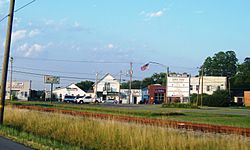
Nassawadox is a small town in Northampton County, Virginia, United States. It is located on a special part of Virginia called the Eastern Shore. In 2020, about 533 people lived there.
The town covers an area of about 0.66 square miles (1.72 square kilometers). It is found right on U.S. Route 13, a main road that runs through the area. Nassawadox is about five miles south of Exmore. It is also about 25 miles north of the large Chesapeake Bay Bridge-Tunnel.
Contents
History of Nassawadox
The name "Nassawadox" comes from an old Native American language. It means "land between two waters." This name makes a lot of sense for the town's location! Nassawadox is bordered on the east by the Atlantic Ocean. To its west is the Chesapeake Bay.
The county and the town are divided into "bayside" and "seaside" areas. These names refer to the land on either side of Route 13. This highway, also known as Lankford Highway, runs through both Accomack and Northampton counties.
Between the Waters Bike Tour
Since 1993, Nassawadox has hosted a fun event called the Between the Waters Bike Tour. This annual bike tour happens every October. It highlights the town's unique location between the two bodies of water. The tour offers different lengths of bike rides between the Eastern Shore's two coasts.
Historic Places in Nassawadox
Two important places near Nassawadox are listed on the National Register of Historic Places. This means they are recognized for their historical importance. These places are Brownsville and the Northampton Lumber Company Historic District.
Population of Nassawadox
The population of Nassawadox has changed over the years. Here's how many people have lived in the town during different census counts:
| Historical population | |||
|---|---|---|---|
| Census | Pop. | %± | |
| 1960 | 650 | — | |
| 1970 | 591 | −9.1% | |
| 1980 | 630 | 6.6% | |
| 1990 | 564 | −10.5% | |
| 2000 | 572 | 1.4% | |
| 2010 | 499 | −12.8% | |
| 2020 | 533 | 6.8% | |
| U.S. Decennial Census 2010 2020 |
|||
In 2020, the town's population was 533 people.
Transportation in Nassawadox
Main Roads
The most important road in Nassawadox is U.S. Route 13. This highway helps connect the town to other places.
Public Transportation Services
STAR Transit offers public transportation in the area. This service helps people travel between Nassawadox and other nearby communities. These include Cape Charles and Onley. It also connects to other towns in Northampton and Accomack counties on the Eastern Shore.
Railroad History
The Bay Coast Railroad used to provide freight train services to Nassawadox. Freight trains carry goods, not people. However, this railroad stopped operating in 2018.
Notable People from Nassawadox
Many interesting people have connections to Nassawadox. Here are a few:
- Arthur "Big Boy" Crudup: A famous blues musician from the 1940s and 1950s.
- D. Page Elmore: A former member of the Maryland House of Delegates, which is part of the state's government.
- Thom Henderson: He created the popular ARC file format for computers. This format was a very early version of the ZIP file format we use today.
- Ralph Northam: He served as the Governor of Virginia.
- George van Driem: A Dutch linguist, someone who studies languages.
- Conny Van Dyke: An actress.
- Todd Washington: An NFL coach and former professional football player. He played for the Tampa Bay Buccaneers and the Houston Texans.
- Johnnie Wittig: A pitcher who played in Major League Baseball.
- Tyler Webb: A relief pitcher currently playing in Major League Baseball for the St. Louis Cardinals.
Climate in Nassawadox
The weather in Nassawadox has hot and humid summers. The winters are generally mild to cool. According to the Köppen Climate Classification system, Nassawadox has a humid subtropical climate. This type of climate is often shown as "Cfa" on climate maps. It means the area gets plenty of rain all year, and has warm temperatures.
See also
 In Spanish: Nassawadox (Virginia) para niños
 | Percy Lavon Julian |
 | Katherine Johnson |
 | George Washington Carver |
 | Annie Easley |

