Natashquan River facts for kids
Quick facts for kids Natashquan River |
|
|---|---|

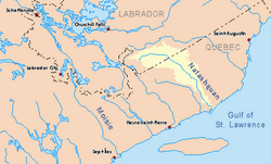
Drainage basin in yellow
|
|
| Country | Canada |
| Provinces | |
| Region | Côte-Nord |
| RCM | Minganie |
| Physical characteristics | |
| Main source | Unnamed wilderness About 210 km (130 mi) ESE of Labrador City, Newfoundland and Labrador 630 m (2,070 ft) 52°31′00″N 63°45′45″W / 52.51667°N 63.76250°W |
| River mouth | Gulf of Saint Lawrence Natashquan FN Reserve, Quebec 0 m (0 ft) 50°07′07″N 61°48′26″W / 50.11861°N 61.80722°W |
| Length | 462 km (287 mi) |
The Natashquan River is a long river in Canada. It flows through the provinces of Quebec and Newfoundland and Labrador. The river travels south until it reaches the Gulf of Saint Lawrence.
Contents
Exploring the Natashquan River
The Natashquan River starts in a wild area, just south of where the waters divide between the Atlantic Ocean and the Saint Lawrence River. It flows southeast towards the border between Labrador and Quebec. From there, it turns south and continues its journey to the Gulf.
The river's entire basin, which is the land area that drains into the river, covers about 16,005 square kilometres (6,180 sq mi). A big part of this area, almost 40%, is in Labrador. The Natashquan River is about 462 kilometres (287 mi) long. About 169 kilometres (105 mi) of its length is in Labrador.
In Quebec, the river forms a natural border between two areas called Minganie and Golfe-du-Saint-Laurent. It then empties into the Gulf of Saint Lawrence. This is about 370 kilometers (230 mi) east of a city called Sept-Îles.
The name "Natashquan" comes from the Innu people. They call it Nutahquaniu Hipu, which means "river where black bear is hunted". This shows how important the river was for hunting.
The Natashquan River is famous for its Atlantic salmon. It's known as one of the best salmon rivers on the North Shore of the Gulf, along with the Moisie River.
River Landscape and Features
The Natashquan River flows through a hilly area called the Grenville geologic province. This area has hills that are between 140 meters (460 ft) and 620 meters (2,030 ft) high. The rocks here are mostly old, hard rocks like gneiss and granite. The river often runs through narrow valleys. Many smaller rivers, about 30 of them, flow into the Natashquan. Some of the important ones include the East Natashquan and West Natashquan Rivers.
The last 18 kilometers (11 mi) of the river is a wide, sandy area called an estuary. This is where the river meets the ocean. It's separated from the main gulf by Natashquan Point and Cape Tiennot. There's also a small place called Sainte-Hélène Island right at the mouth of the river.
The climate around the river is subarctic continental. This means it has cold winters and short summers. The upper part of the river basin is cold and somewhat dry. The lower part is more humid.
History of the Natashquan River
In 1534, a famous explorer named Jacques Cartier sailed past this area. He named Cape Thiennot after a ship captain. Later, in 1684, Louis Jolliet mapped the river and called it "Noutascoüan". Other old maps also showed the river with similar names.
For a long time, people used the river for trade. As early as 1710, a trading post was set up on the river's bank. This was a place where people traded furs with the local Innu people. The Hudson's Bay Company took over the post in the mid-1800s. However, they closed it around 1914 because it wasn't making enough money.
More recently, a new bridge was built over the river. This bridge carries Quebec Route 138 and was opened on September 26, 2013. It helps people travel more easily across the river.
Protecting the Natashquan River
Efforts are being made to protect the Natashquan River and its surroundings. A large area of about 4,089 square kilometres (1,579 sq mi) is being considered to become a special biodiversity reserve. This reserve would stretch for 190 kilometres (120 mi) along the Natashquan River, starting from the Labrador–Quebec border. It would also include 105 kilometres (65 mi) of the East Natashquan River.
The goal of this reserve is to protect the beautiful natural areas. It aims to keep the homes of Atlantic salmon safe. It also helps protect the many different kinds of plants and animals that live in and around the river. Old-growth forests, which are very old and untouched forests, would also be protected. The reserve would allow for traditional activities like fur trapping. It would also help develop tourism. However, activities like mining, cutting down trees, and building dams for electricity would not be allowed.
In May 2015, the government of Quebec started a special program for sport fishing. For large salmon on many rivers, including the Natashquan, anglers had to catch and then release the fish. This means they couldn't keep the salmon. This rule was put in place to help protect the salmon population, which was getting smaller. Some groups, like the Quebec Atlantic Salmon Federation, felt that even more rules were needed to truly protect the salmon for the future.
See also
 In Spanish: Río Natashquan para niños
 | Lonnie Johnson |
 | Granville Woods |
 | Lewis Howard Latimer |
 | James West |

