
National Register of Historic Places listings in Brevard County, Florida facts for kids

This page lists special places in Brevard County, Florida that are part of the National Register of Historic Places. Think of it like a national list of important buildings, areas, or sites that tell a story about America's past. These places are protected because they are valuable parts of history.
There are 42 places in Brevard County on this list. Two of them are even more special and are called National Historic Landmarks. These landmarks are super important to the history of the whole country! One place used to be on the list but was removed.
Contents
Space History Landmarks
Brevard County is famous for space exploration! Several places connected to the space program are on the National Register.

The Cape Canaveral Air Force Station is a very important place for space history. It includes many old launch pads (like 5, 6, 13, 14, 19, 26, and 34) and the Mission Control Center. These are the places where many early rockets and spacecraft were launched. It's where America's journey into space really began! This site was added to the list in 1984.
Kennedy Space Center Sites
The Kennedy Space Center (KSC) has many historic parts. These are places where astronauts trained, rockets were built, and missions were controlled.
Launch Complex 39

Kennedy Space Center Launch Complex 39 is a huge area where some of the biggest rockets in history were launched. This includes the famous Saturn V rockets that took astronauts to the Moon. It was added to the list in 1973.
Launch Pads A and B
.jpg)
Within Launch Complex 39, there are two specific launch pads, Pad A and Pad B, that are also on the list. These pads were used for many Space Shuttle launches and other important missions. They were recognized in 2000.
Vehicle Assembly Building

The Vehicle Assembly Building (VAB) is one of the largest buildings in the world. It's where different parts of rockets and spacecraft were put together before they were moved to the launch pads. It was added to the list in 2000.
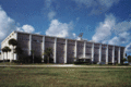
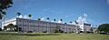
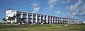
Other KSC Buildings
Other important buildings at Kennedy Space Center include the Central Instrumentation Facility, the Headquarters Building, the Launch Control Center, and the Operations and Checkout Building. These places were vital for managing missions and preparing spacecraft. They were all added to the list in 2000.
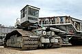
Crawlerway and Transporter Facilities

The Crawlerway is a special road built to move huge rockets and spacecraft from the Vehicle Assembly Building to the launch pads. The Missile Crawler Transporter Facilities are the giant vehicles that drive on this road. These unique parts of KSC were added in 2000.
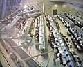
Press Site

The Press Site, with its famous clock and flag pole, is where reporters and guests watch rocket launches. It's a place where many historic moments were shared with the world. It was added to the list in 2000.
Historic Homes and Buildings
Many old houses and buildings in Brevard County are on the National Register because they show us how people lived in the past.
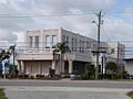
Aladdin Theater

The Aladdin Theater in Cocoa is a beautiful old movie theater. It was built a long time ago and still stands as a reminder of past entertainment. It was added to the list in 1991.
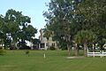
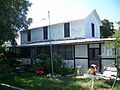
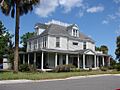
William H. Gleason House

The William H. Gleason House in Melbourne is a historic home. William H. Gleason was an important person in the early history of Melbourne. His house was added to the list in 1997.
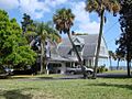
Green Gables
_003.jpg)
Green Gables is another historic home in Melbourne. It's known for its unique architecture and history. It was added to the list in 2016.
Porcher House

The Porcher House in Cocoa is a grand old house. It was built by a prominent family in the area. It was added to the list in 1986.
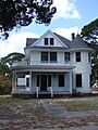
Pritchard House

The Pritchard House in Titusville is a well-preserved historic home. It shows us what homes looked like in the late 1800s. It was added to the list in 1990.
Jorgensen's General Store

Jorgensen's General Store in Grant-Valkaria was a central part of its community for many years. General stores were important places where people bought everything they needed. It was added to the list in 1999.
Historic Districts
Some areas have many historic buildings together, forming a "historic district."
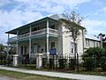
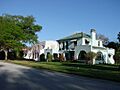
Barton Avenue Residential District

The Barton Avenue Residential District in Rockledge is a neighborhood with many old homes. These homes show the architectural styles popular in the past. It was added to the list in 1992.
Rockledge Drive Residential District

Another historic neighborhood in Rockledge is the Rockledge Drive Residential District. It features many beautiful old houses along the Indian River. It was added to the list in 1992.
Titusville Commercial District

The Titusville Commercial District includes many historic buildings in downtown Titusville. These buildings were once busy shops and businesses. It was added to the list in 1990.
Churches and Cemeteries
Old churches and cemeteries often hold important historical and cultural value.
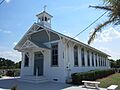
City Point Community Church

The City Point Community Church in Cocoa is a historic church building. It has been a place of worship for many years. It was added to the list in 1995.
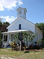
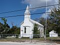
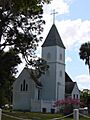
Community Chapel of Melbourne Beach

The Community Chapel of Melbourne Beach is a charming old chapel. It has served the community of Melbourne Beach for a long time. It was added to the list in 1992.
La Grange Church and Cemetery

The La Grange Church and Cemetery in Titusville is a historic site that includes both a church and a cemetery. It tells us about the early settlers and their lives. It was added to the list in 1995.
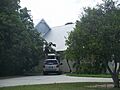
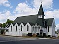
Old St. Luke's Episcopal Church and Cemetery

Old St. Luke's Episcopal Church and Cemetery in Courtenay is another important religious site. It shows the history of faith in the area. It was added to the list in 1990.
St. Gabriel's Episcopal Church

St. Gabriel's Episcopal Church in Titusville is a historic church building. It was added to the list in 1972.
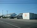
St. Joseph's Catholic Church
_001.jpg)
St. Joseph's Catholic Church in Palm Bay is a historic Catholic church. It was added to the list in 1987.
Other Interesting Sites
Melbourne Beach Pier

The Melbourne Beach Pier is a historic pier that stretches out into the water. Piers were important for fishing, shipping, and recreation in the past. It was added to the list in 1984.
Old Haulover Canal

The Old Haulover Canal is a historic waterway that connects the Indian River Lagoon to the Mosquito Lagoon. Canals were important for transportation and trade. It was added to the list in 1978.
Windover Archaeological Site

The Windover Archaeological Site is a very important archaeological site near Titusville. It's where scientists found ancient human remains and artifacts that are thousands of years old. This site helps us understand early human life in Florida. It is a National Historic Landmark and was added to the list in 1987.
Images for kids
-
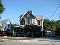
A house in the Barton Avenue Residential District
-
The Central Instrumentation Facility at KSC
-
City Point Community Church
-

Community Chapel of Melbourne Beach
-
The J. R. Field Homestead
-
Florida Power and Light Company Ice Plant
-
The Headquarters Building at KSC
-
The Dr. George E. Hill House
-
Hotel Mims
-

Indian Fields (address restricted)
-
La Grange Church and Cemetery
-
The Launch Control Center
-
Missile Crawler Transporter Facilities
-
Old St. Luke's Episcopal Church
-
Operations and Checkout Building
-
The Judge George Robbins House
-
The James Wadsworth Rossetter House
-
The Spell House
-
St. Gabriel's Episcopal Church
-
St. Joseph's Catholic Church
-
A house in the Valencia Subdivision Residential District
-
The Wager House
-
Marion S. Whaley Citrus Packing House


