
National Register of Historic Places listings in Bristol County, Rhode Island facts for kids

Have you ever wondered about old buildings and places that are super important to history? In Bristol County, Rhode Island, there's a special list called the National Register of Historic Places. This list helps protect and celebrate places that tell us stories about the past. It's like a hall of fame for historic buildings, neighborhoods, and even bridges!
Bristol County is a part of Rhode Island, a small state in the United States. This county has 24 amazing places on the National Register. One of them is even more special and is called a National Historic Landmark! These places are important because they show us how people lived, worked, and built things many years ago.
What is the National Register of Historic Places?
The National Register of Historic Places is the official list of the nation's historic places worth saving. It's managed by the National Park Service. When a place is added to this list, it means it's recognized for its historical, architectural, archaeological, engineering, or cultural importance. It helps people understand why these places are special and encourages their preservation.
Why are these places important?
These historic places are like giant storybooks. They can teach us about:
- How people lived: Old houses show us how families used to live, what their homes looked like, and what materials they used.
- Important events: Some places are famous because big historical events happened there, like battles or important meetings.
- Cool architecture: Many buildings are amazing examples of different building styles from the past.
- Community history: Historic districts, which are groups of buildings, can show how entire towns grew and changed over time.
Historic Places in Bristol County
Bristol County is full of interesting spots. Let's explore some of the cool places on the National Register!
Barrington's Historic Gems
The town of Barrington has several places on the list.
Alfred Drowne Road Historic District
This district includes Alfred Drowne Road, Annawamscutt Road, and Washington Road. It was added to the list in 2005. Historic districts are areas with many old buildings that together tell a story about a neighborhood's past.
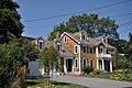
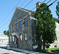
Allen-West House
Located at 153 George Street, the Allen-West House was added in 2013. It's a single house recognized for its unique history and architecture.
Barrington Civic Center Historic District
This area on County Road became historic in 1976. It includes important public buildings that show how the town center developed.

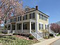
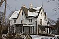
Belton Court
Belton Court, found on Middle Highway, was listed in 1976. It's another example of a significant historic home in Barrington.
Benjamin Aborn Jackson House
This house at 115 Nayatt Road was added in 2008. It's a great example of a historic home that has been preserved.
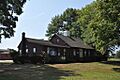
Jennys Lane Historic District
This district, including Jennys Lane and Mathewson and Rumstick Roads, joined the list in 2008. It's another neighborhood that has kept its historic feel.
Nayatt Point Lighthouse

The Nayatt Point Lighthouse, located at Nayatt Point, was added in 1988. Lighthouses are super important for guiding ships and are often beautiful old structures.
O'Bannon Mill
At 90 Bay Spring Avenue, the O'Bannon Mill was listed in 1996. Mills are important because they show us how industries and factories used to work.
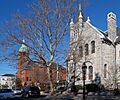
St. Matthew's Episcopal Church
This church at 5 Chapel Road was added in 1991. Churches are often very old and have beautiful architecture, playing a big role in a community's history.
Bristol's Rich History
Bristol is another town in Bristol County with many historic sites.
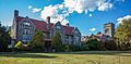
Blithewold Mansion, Gardens and Arboretum

This beautiful estate on Ferry Road was listed in 1980. It was a summer home built in the 1890s by a wealthy coal businessman named Augustus Van Wickle. It's known for its mansion, lovely gardens, and many different kinds of trees (an arboretum).
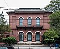
Bristol County Courthouse
The courthouse on High Street was added in 1970. Courthouses are important buildings where laws are made and justice is served.
Bristol County Jail
The old jail at 48 Court Street was listed in 1973. Even old jails can be historically important, showing us how the justice system worked in the past.
Bristol Customshouse and Post Office
This building at 420-448 Hope Street was added in 1972. Customshouses were places where taxes were collected on goods coming into the country, and post offices are where mail is handled.
Bristol Ferry Lighthouse

The Bristol Ferry Lighthouse on Ferry Road was listed in 1988. Another important lighthouse that helped guide boats safely.
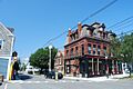
Bristol Waterfront Historic District
This large district covers the area from Bristol Harbor to the east side of Wood Street, stretching north to Washington Street and south to Walker Cove. It was added in 1975. This area shows the history of Bristol as a port town.
Benjamin Church House
The Benjamin Church House at 1014 Hope Street was listed in 1971. Many old houses are named after important people who lived there.
Juniper Hill Cemetery
This cemetery at 24 Sherry Avenue was added in 1998. Cemeteries can be historic because they contain old gravestones and monuments that tell stories about the people who lived in the area.
Longfield
Longfield, located at 1200 Hope Street, was listed in 1972. It's another significant historic house in Bristol.
Mount Hope Bridge

The Mount Hope Bridge, which crosses Narragansett Bay on RI 114, was added in 1976. Bridges are important for transportation and can be amazing examples of engineering.
Mount Hope Farm
Mount Hope Farm on Metacom Avenue was listed in 1977. Farms can be historic because they show us how agriculture and farming have changed over time.
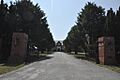
Poppasquash Farms Historic District
This district, off RI 114, was added in 1980. It includes Colt State Park and other nearby properties, showing a historic farming area.
Joseph Reynolds House (National Historic Landmark)

The Joseph Reynolds House at 956 Hope Street is very special because it's a National Historic Landmark. It was listed in 1972. This house is the oldest three-story wooden house in New England, built around 1700! It was even used as a headquarters by Lafayette, a famous French general who helped America during the American Revolutionary War, in 1778.
Warren's Waterfront and Church
The town of Warren also has important historic places.
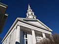
Warren United Methodist Church and Parsonage
This church and its parsonage (the minister's house) at 27 Church Street were listed in 1971.
Warren Waterfront Historic District
This district is bounded by the Warren River, Belcher Cove, and the old town line, including Main Street to Campbell Street. It was added in 1974. Like Bristol's waterfront, this area shows the history of Warren as a busy port.
Images for kids
-
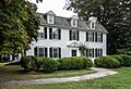
A historic home in the Alfred Drowne Road Historic District.
-
The Allen-West House in Barrington.
-
Belton Court, a historic estate.
-
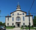
The Bristol County Courthouse.
-
The old Bristol County Jail.
-
The Bristol Customshouse and Post Office.
-
Thames Street in the Bristol Waterfront Historic District.
-
The Benjamin Church House.
-
The Benjamin Aborn Jackson House.
-
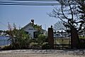
A boathouse in the Jennys Lane Historic District.
-
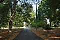
Juniper Hill Cemetery.
-
Longfield House.
-
Governor Bradford House at Mount Hope Farm.
-
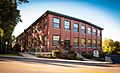
The O'Bannon Mill.
-
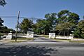
Entrance gate to Colt State Park, part of the Poppasquash Farms Historic District.
-
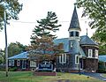
St. Matthew's Episcopal Church.
-
Warren United Methodist Church.
-
A street in the Warren Waterfront Historic District.


