National Register of Historic Places listings in Clallam County, Washington facts for kids
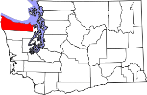
Welcome to a special list of amazing places in Clallam County, Washington! These are buildings, sites, and structures that are super important to history. They are officially recognized on the National Register of Historic Places. This list helps us remember and protect these cool spots for everyone to enjoy.
You can find 49 different places in Clallam County that are on this special list. Each one has a unique story to tell about the past!
Historic Places in Clallam County
| Name on the Register | Image | Date listed | Location | City or town | Description | |
|---|---|---|---|---|---|---|
| 1 | Aircraft Warning Service Observation Tower |
(#93000363) |
216 Spring Rd. 48°06′13″N 123°14′59″W / 48.103611°N 123.249722°W |
Agnew | This tower was used during World War II to watch for enemy aircraft. It helped protect the area by spotting planes. | |
| 2 | Altair Campground Community Kitchen |
(#07000732) |
Approx. 4 mi. S of US 101 48°00′42″N 123°35′30″W / 48.011667°N 123.591667°W |
Port Angeles | This kitchen was built for people camping at Altair Campground. It provided a shared space for cooking and gathering. | |
| 3 | Beaver School |
(#92001591) |
US 101 N, W side 48°03′50″N 124°18′38″W / 48.063889°N 124.310556°W |
Beaver | The Beaver School is an example of the old rural schools in Washington State. It served students in the Beaver community for many years. | |
| 4 | Blue Mountain School |
(#87001938) |
Blue Mountain Rd. 48°03′02″N 123°16′21″W / 48.050556°N 123.2725°W |
Port Angeles | Another historic rural school, the Blue Mountain School shows how education was provided in smaller communities. | |
| 5 | Canyon Creek Shelter |
(#07000712) |
Approximately .9 miles north of the Upper Sol Duc River Trailhead 47°57′00″N 123°49′05″W / 47.9499°N 123.8180°W |
Port Angeles | This shelter provided a safe place for travelers and rangers in the wilderness of Olympic National Park. | |
| 6 | Clallam County Courthouse |
(#87001459) |
319 Lincoln St. 48°06′57″N 123°25′55″W / 48.115833°N 123.431944°W |
Port Angeles | The Clallam County Courthouse is where local government decisions are made. It's an important building for the community. | |
| 7 | Dodger Point Fire Lookout |
(#07000736) |
Approx. 13 mi. along Dodger Point Trail starting at the Whiskey Bend Trail 47°52′29″N 123°30′29″W / 47.874722°N 123.508056°W |
Port Angeles | Fire lookouts like this one helped spot forest fires early, protecting the beautiful forests of the Olympic Peninsula. | |
| 8 | Dungeness River Bridge |
(#82004201) |
Spans Dungeness River 48°05′08″N 123°08′46″W / 48.085556°N 123.146111°W |
Sequim | This bridge crosses the Dungeness River and is a historic example of bridge building in Washington State. | |
| 9 | Dungeness School |
(#88000627) |
657 Towne Rd. 48°08′34″N 123°07′38″W / 48.142778°N 123.127222°W |
Dungeness | The Dungeness School is another historic school building that shows how communities valued education in the past. | |
| 10 | Eagle Ranger Station |
(#07000713) |
Approximately 11.6 miles south of WA 101 on Upper Sol Duc Rd. 47°58′19″N 123°51′52″W / 47.971944°N 123.864444°W |
Port Angeles | Ranger stations were important for managing and protecting national parks and forests. | |
| 11 | Elkhorn Guard Station |
(#07000714) |
Approximately 11.5 miles along Elwha River Trail from the Whiskey Bend Trailhead 47°52′16″N 123°28′03″W / 47.8711°N 123.4674°W |
Port Angeles | Guard stations like Elkhorn helped park rangers watch over the wilderness and assist visitors. | |
| 12 | Elwha Campground Community Kitchen |
(#07000735) |
3 miles south of U.S. Route 101 in Washington 48°01′39″N 123°35′13″W / 48.0275°N 123.586944°W |
Port Angeles | This kitchen provided a shared space for campers at the Elwha Campground. | |
| 13 | Elwha Ranger Station |
(#07000716) |
Approximately 3 miles southeast of WA 101 on the Olympic Hot Springs Rd. 48°01′00″N 123°35′27″W / 48.016667°N 123.590833°W |
Port Angeles | The Elwha Ranger Station was a key spot for managing the Elwha River area of the park. | |
| 14 | Elwha River Bridge |
(#82004200) |
Old Hwy. 112 48°06′04″N 123°33′23″W / 48.101111°N 123.556389°W |
Elwha | This old bridge over the Elwha River is part of Washington's historic transportation system. | |
| 15 | Elwha River Hydroelectric Power Plant |
(#88002741) |
N end of Lake Aldwell 48°05′42″N 123°33′18″W / 48.095°N 123.555°W |
Port Angeles | The Elwha Dam was once a source of electricity. It was removed to help the river and fish return to their natural state. | |
| 16 | Emery Farmstead |
(#88002746) |
Emery Rd. 48°04′12″N 123°15′41″W / 48.07°N 123.261389°W |
Port Angeles | The Emery Farmstead shows what life was like for farming families in the past. | |
| 17 | Fifteen Mile Shelter |
(#07000715) |
Approx. 12.4 mi. from park boundary on N Fork Bogachiel R Trail 47°54′10″N 124°01′14″W / 47.902778°N 124.020556°W |
Port Angeles | This shelter offered protection for people traveling deep into the park's trails. | |
| 18 | Glines Canyon Hydroelectric Power Plant |
(#88002742) |
N end of Lake Mills at Elwha River 48°00′11″N 123°35′54″W / 48.003056°N 123.598333°W |
Port Angeles | Similar to the Elwha Dam, this power plant also helped generate electricity. It was also removed to restore the river. | |
| 19 | Hoko River Archeological Site |
(#78002735) |
Address Restricted |
Pysht | This site holds clues about ancient people who lived along the Hoko River. It's a place of important discoveries. | |
| 20 | Hoko River Rockshelter Archeological Site |
(#80003997) |
Address Restricted |
Sekiu | Another archaeological site, this rockshelter provides more information about early human life in the area. | |
| 21 | Humes Ranch Cabin |
(#77001332) |
S of Port Angeles on Elwha River 47°56′53″N 123°32′39″W / 47.948056°N 123.544167°W |
Port Angeles | This cabin belonged to the Humes family, early settlers who lived and worked along the Elwha River. | |
| 22 | Hyak Shelter |
(#07000721) |
Approx. 15.4 mi. from park boundary on N Fork Bogachiel River Trail 47°55′27″N 123°58′14″W / 47.924167°N 123.970556°W |
Port Angeles | The Hyak Shelter offered a place of rest and safety for those exploring the remote parts of the park. | |
| 23 | John A. Hyer Farm |
(#94000797) |
Address Restricted |
Sequim | The John A. Hyer Farm represents the agricultural history of the Sequim area. | |
| 24 | Manis Mastodon Site |
(#78002736) |
Address Restricted |
Sequim | This incredible site is where scientists found evidence of early humans interacting with a mastodon, a huge ancient elephant-like animal. | |
| 25 | Masonic Temple |
(#89000400) |
622 S. Lincoln St. 48°06′48″N 123°26′08″W / 48.113333°N 123.435556°W |
Port Angeles | The Masonic Temple is a historic building used by the Masons, a fraternal organization. | |
| 26 | McAlmond House |
(#76001879) |
N of Sequim on Dungeness Bay 48°09′03″N 123°08′05″W / 48.150833°N 123.134722°W |
Sequim | The McAlmond House is a historic home located near the beautiful Dungeness Bay. | |
| 27 | Michael's Cabin |
(#07000733) |
Along Elwha River Trail; approx 2 mi. from Whiskey Bend Trailhead 47°57′12″N 123°33′11″W / 47.953333°N 123.553056°W |
Port Angeles | Michael's Cabin is another historic structure along the Elwha River Trail, offering a glimpse into past life in the park. | |
| 28 | Naval Lodge Elks Building |
(#86000956) |
131 E. First St. 48°07′07″N 123°25′51″W / 48.118611°N 123.430833°W |
Port Angeles | This building was home to the Naval Lodge Elks, another community organization. | |
| 29 | New Dungeness Light Station |
(#93001338) |
Dungeness Spit 48°10′56″N 123°06′17″W / 48.182222°N 123.104722°W |
Sequim | The New Dungeness Light Station is a lighthouse that has guided ships safely for many years. | |
| 30 | North Fork Sol Duc Shelter |
(#07000725) |
Approx. 9.5 mi. from North Fork Sol Duc Trailhead 47°59′56″N 123°45′42″W / 47.998889°N 123.761667°W |
Port Angeles | This shelter is located along the North Fork Sol Duc Trail, providing a stopping point for hikers. | |
| 31 | Olympic National Park Headquarters Historic District |
(#07000720) |
600 E. Park Ave. 48°06′03″N 123°25′58″W / 48.100833°N 123.432778°W |
Port Angeles | This district includes the main offices for Olympic National Park, where important decisions about the park are made. | |
| 32 | Ozette Indian Village Archeological Site |
(#74000916) |
Address Restricted |
La Push | The Ozette Indian Village is a very important archaeological site. It shows how the Makah people lived thousands of years ago. | |
| 33 | Joseph Paris House |
(#87001939) |
101 E. Fifth St. 48°06′57″N 123°26′06″W / 48.115833°N 123.435°W |
Port Angeles | The Joseph Paris House is a historic home in Port Angeles, showing the architecture of its time. | |
| 34 | Port Angeles Civic Historic District |
(#11000259) |
205, 215, 217 & 319 S. Lincoln St. 48°07′01″N 123°25′58″W / 48.116944°N 123.432778°W |
Port Angeles | This district includes several important public buildings in Port Angeles, like the old Carnegie Library and the City Building. | |
| 35 | Pyramid Peak Aircraft Warning Service Lookout |
(#07000726) |
3.5 miles up Pyramid Pk.trail at end of Camp David Jr. Rd. 48°04′30″N 123°48′44″W / 48.075°N 123.812222°W |
Port Angeles | Another lookout tower, this one on Pyramid Peak, helped keep an eye out for aircraft during wartime. | |
| 36 | Peter Roose Homestead |
(#07000723) |
Along Indian Village Trail; approximately 1.5 miles north of trailhead 48°09′42″N 124°42′24″W / 48.1617°N 124.7067°W |
Port Angeles | The Peter Roose Homestead shows how early settlers lived and built their homes in the wilderness. | |
| 37 | Rosemary Inn |
(#79001033) |
SW of Port Angeles on Barnes Point 48°03′36″N 123°47′33″W / 48.06°N 123.7925°W |
Port Angeles | The Rosemary Inn was a historic place for visitors to stay, offering a glimpse into early tourism. | |
| 38 | Sekiu School |
(#91000539) |
Rice St. 48°15′47″N 124°18′02″W / 48.263056°N 124.300556°W |
Sekiu | The Sekiu School is another example of a historic rural school building in Clallam County. | |
| 39 | Sequim Opera House |
(#91000632) |
119 N. Sequim Ave. 48°04′49″N 123°06′04″W / 48.080278°N 123.101111°W |
Sequim | The Sequim Opera House was a place for entertainment and community gatherings in the early 1900s. | |
| 40 | Singer's Lake Crescent Tavern |
(#07000724) |
Barnes Point, south shore of Lake Crescent, WA 101 48°03′25″N 123°48′00″W / 48.056944°N 123.8°W |
Port Angeles | This lodge on Lake Crescent has welcomed visitors for many years, offering a beautiful place to stay in the park. | |
| 41 | St. Andrew's Episcopal Church |
(#87001942) |
206 S. Peabody St. 48°06′58″N 123°25′41″W / 48.116111°N 123.428056°W |
Port Angeles | St. Andrew's Episcopal Church is a historic place of worship in Port Angeles. | |
| 42 | Storm King Ranger Station |
(#07000730) |
Barnes Pt., S side of Lake Crescent off US 101 48°03′29″N 123°47′14″W / 48.058056°N 123.787222°W |
Port Angeles | The Storm King Ranger Station helped manage the area around Lake Crescent. | |
| 43 | Tatoosh Island |
(#72001267) |
NW of Cape Flattery 48°23′31″N 124°44′01″W / 48.391944°N 124.733611°W |
Olympic Peninsula | Tatoosh Island is a small island with a lighthouse, important for navigation and rich in Native American history. | |
| 44 | Three Forks Shelter |
(#07000728) |
Approx. 4.5 mi. from the Three Fords Trailhead at Deer Park Campground 47°54′56″N 123°14′44″W / 47.915556°N 123.245556°W |
Port Angeles | This shelter provided a safe haven for hikers in the Deer Park area of the Olympic National Park. | |
| 45 | Tse whit zen Village |
(#14000848) |
Address Restricted 48°07′49″N 123°27′42″W / 48.1302°N 123.4618°W |
Port Angeles vicinity | Tse-whit-zen is an ancient village site of the Lower Elwha Klallam Tribe. It's a very important cultural and historical place. | |
| 46 | U.S. Post Office |
(#83003321) |
W. 1st and Oak Sts. 48°07′10″N 123°26′02″W / 48.119444°N 123.433889°W |
Port Angeles | This historic building served as the main post office for Port Angeles for many years. | |
| 47 | US Quarantine Station Surgeon's Residence |
(#89000401) |
101 Discovery Way, Diamond Point 48°05′40″N 122°55′10″W / 48.094444°N 122.919444°W |
Sequim | This building was the home of the doctor at the U.S. Quarantine Station, where people arriving by ship were checked for illnesses. | |
| 48 | Wedding Rock Petroglyphs |
(#76000951) |
Address Restricted |
Forks | These petroglyphs are ancient rock carvings made by Native Americans, telling stories and marking important places. | |
| 49 | Wendel Property |
(#07000739) |
5 miles north on East Shore Rd. 48°05′42″N 123°47′59″W / 48.095°N 123.799722°W |
Port Angeles | The Wendel Property is a historic site that contributes to the understanding of the area's development. |
Images for kids

All content from Kiddle encyclopedia articles (including the article images and facts) can be freely used under Attribution-ShareAlike license, unless stated otherwise. Cite this article:
National Register of Historic Places listings in Clallam County, Washington Facts for Kids. Kiddle Encyclopedia.


