
National Register of Historic Places listings in Davidson County, North Carolina facts for kids

Have you ever wondered about the oldest buildings or special places in your community? In Davidson County, North Carolina, many important historical sites are officially recognized on the National Register of Historic Places. This special list helps protect and celebrate places that tell us about the past. You can even find an online map of all these places by clicking the "Map of all coordinates" link on the right side of the original article.
Contents
Exploring Davidson County's Historic Places
What is the National Register of Historic Places?
The National Register of Historic Places is like a hall of fame for buildings, structures, objects, sites, and districts that are important in American history, architecture, archaeology, engineering, or culture. When a place is added to this list, it means it's recognized for its special value. This helps people understand why these places are important and encourages their preservation. It's a way to keep history alive for future generations!
Discovering Historic Sites in Davidson County
Davidson County is home to many fascinating places on the National Register. These sites include old churches, homes, schools, mills, and even entire historic neighborhoods. Each one has a unique story to tell about the people and events that shaped this area.
Historic Churches and Cemeteries
Many of Davidson County's historic listings are old churches and their cemeteries. These places often show us how communities grew and how people lived and worshipped long ago.
- Abbott's Creek Primitive Baptist Church Cemetery: Located near Thomasville, this cemetery is part of a group of historic Anglo-German cemeteries. It was listed on July 10, 1984.
- Beck's Reformed Church Cemetery: Found near Silver Hill, this is another Anglo-German cemetery listed on the same day in 1984.
- Bethany Reformed and Lutheran Church Cemetery: This cemetery near Midway also joined the list on July 10, 1984, as part of the Anglo-German Cemeteries group.
- Beulah Church of Christ Cemetery: Near Welcome, this cemetery was listed in 1984, highlighting its historical importance.
- Emanuel United Church of Christ Cemetery: This cemetery, close to Thomasville, was added to the Register in 1984.
- Fair Grove Methodist Church Cemetery: Located near South Thomasville, this cemetery was listed in 1984. It's a place where you can see the history of the community.
- Good Hope Methodist Church Cemetery: Near Welcome, this cemetery was recognized in 1984.
- Jersey Baptist Church Cemetery: This historic cemetery near Linwood was listed on July 10, 1984.
- Pilgrim Reformed Church Cemetery: Found near Lexington, this cemetery was added to the Register in 1984.
- Spring Hill Methodist Protestant Church Cemetery: Near High Point, this cemetery was listed in 1984.
- St. Luke's Lutheran Church Cemetery: This cemetery near Tyro was also listed on July 10, 1984.
- Waggoner Graveyard: Located near Welcome, this graveyard was listed in 1984.
Important Homes and Farms
Many historic homes and farms in Davidson County show us how people lived and worked in the past.
- Adderton - Badgett House: This house near Denton was listed in 1984. It's part of a larger group of historic places in Davidson County.
- Beallmont: Located near Linwood, this property was added to the Register in 1984.
- Brummell's Inn: North of Thomasville, this old inn was listed on November 25, 1980. Inns were important places for travelers in the past.
- Hamilton Everhart Farm: This farm near Midway was listed in 1984. It helps tell the story of farming in the county.
- Riley Everhart Farm and General Store: Located near Arnold, this property was listed in 1984. General stores were once the heart of many small communities.
- Haden Place: This historic site near Tyro was added to the Register in 1984.
- Hampton House: Near Arcadia, this house was listed in 1984.
- Dr. William Rainey Holt House: Located at 408 S. Main Street in Lexington, this house was listed on June 23, 1983. Dr. Holt was an important figure in the area.
- Capt. John Koonts, Jr., Farm: This farm near Tyro was listed in 1984.
- Shadrach Lambeth House: Near Thomasville, this house was added to the Register in 1984.
- Eli Moore House: This house near High Point was listed in 1984.
- Reid Farm: West of Jackson Hill, this farm was recognized on January 25, 1979.
- Henry Shoaf Farm: Located near Lexington, this farm was listed in 1984.
- Philip Sowers House: This house near Churchland was listed on November 25, 1980.
- Spurgeon House: West of High Point, this house was listed on April 20, 1983.
- George W. Wall House: Near Wallburg, this house was listed in 1984.
Schools, Mills, and Other Buildings
Davidson County also has historic schools, mills, and other important buildings that show its industrial and educational past.
- Chapel Hill Church Tabernacle: This tabernacle near Denton was listed on April 24, 2012.
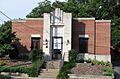
- Church Street School: Located in Thomasville, this school was listed on March 1, 1990. It's an important part of the town's educational history.
- First Reformed Church: This church at 22 E. Center Street in Lexington was listed on April 28, 2000.
- Grace Episcopal Church: Located at 419 S. Main Street in Lexington, this church was listed on December 20, 2006.
- Grimes Brothers Mill: This mill at 2 North State Street in Lexington was listed on May 2, 2002. Mills were very important for the economy in the past.
- Grimes School: Located in Lexington, this school was listed on December 28, 1988.
- Grimes-Crotts Mill: This mill near Reedy Creek was listed in 1984.
- Hedrick's Grove Reformed Church: Located at 3840 Allred Road in Lexington, this church was listed on January 31, 2008.
- Jersey Settlement Meeting House: Near Linwood, this meeting house was listed in 1984. Meeting houses were important community gathering places.
- Junior Order United American Mechanics National Orphans Home: This home near Lexington was listed in 1984. It provided care for children.
- Lexington Memorial Hospital: Located at 111 North Carolina Avenue in Lexington, this hospital was listed on May 24, 2012.
- Mitchell House: This house at 411 Biggs Avenue in Thomasville was listed on September 20, 2000.
- Mor-Val Hosiery Mill: Located at N. Main and E. First Streets in Denton, this mill was listed on October 5, 2001. It shows the history of textile production.
- Mount Ebal Methodist Protestant Church: This church near Denton was listed in 1984.
- Old Davidson County Courthouse: Located at Main and Center Streets in Lexington, this historic courthouse was listed on June 24, 1971. Courthouses are central to a county's government and history.
- Smith Clinic: This clinic at 17 Randolph Street in Thomasville was listed on November 29, 1991.
- Adam Spach Rock House Site: This site near Winston-Salem was listed on June 14, 2002. The exact address is restricted to protect the site.
- Thomasville Railroad Passenger Depot: Located on W. Main Street in Thomasville, this old train station was listed on July 9, 1981. Train depots were once bustling centers of travel and trade.
- Tyro Tavern: This tavern near Tyro was listed on August 16, 1984. Taverns were important stops for travelers.
Historic Districts
Sometimes, not just one building, but an entire area or neighborhood is considered historic. These are called historic districts.
- Erlanger Mill Village Historic District: This district in Lexington was listed on January 9, 2008. It includes homes and buildings related to the old Erlanger Mill.
- Lexington Residential Historic District: This large district in Lexington was listed on April 19, 2007. It covers many historic homes and streets.
- Randolph Street Historic District: This district in Thomasville was listed on August 28, 2012.
- Salem Street Historic District: Another district in Thomasville, listed on August 9, 2006.
- Thomasville Downtown Historic District: The downtown area of Thomasville was listed on September 1, 2005, recognizing its historic commercial buildings.
- Uptown Lexington Historic District: The main street area of Lexington was listed on May 16, 1996.
- Yadkin College Historic District: This district near Yadkin College was listed on February 25, 1988.
These historic places help us understand the rich history of Davidson County and North Carolina. By learning about them, we can appreciate the past and work to preserve these treasures for the future.
Images for kids
-
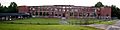
Church Street School in Thomasville.
-
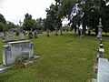
Fair Grove Methodist Church Cemetery.
-
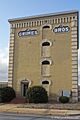
Grimes Brothers Mill in Lexington.
-
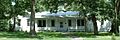
Mitchell House in Thomasville.
-
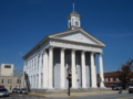
The Old Davidson County Courthouse in Lexington.
-
Smith Clinic in Thomasville.
-

Image for Adam Spach Rock House Site (address restricted).


