
National Register of Historic Places listings in El Dorado County, California facts for kids

El Dorado County in California is a place rich in history, especially from the exciting days of the California Gold Rush. Many buildings, places, and areas in this county are so important that they have been added to a special list called the National Register of Historic Places. This list helps protect and celebrate places that tell us about America's past.
In El Dorado County, there are 20 different places on this list. One of them is even more special and is called a National Historic Landmark, which means it's super important to the history of the whole country! Let's explore some of these amazing historic sites.
Historic Gold Rush Sites
El Dorado County is famous for being the heart of the California Gold Rush. Many historic places here remind us of that exciting time.
Coloma: Where the Gold Rush Began

One of the most important places in El Dorado County, and indeed in all of California, is Coloma. This town is a National Historic Landmark because it's where the California Gold Rush officially started! In 1848, a man named James W. Marshall found gold flakes at Sutter's Mill while building a sawmill. This discovery changed California forever, bringing thousands of people hoping to strike it rich. Today, you can visit Marshall Gold Discovery State Historic Park in Coloma to see a replica of Sutter's Mill and learn about the early days of the Gold Rush.
Historic Mines and Mills
The Gold Rush wasn't just about finding gold; it was also about the hard work of mining it.
Gold Bug Mine in Placerville

The Hattie (Gold Bug), Priest and Silver Pine Mines and Stampmill in Placerville are a great example of this. The Gold Bug Mine is a real hard-rock gold mine that you can actually explore! It shows how miners dug deep into the earth to find gold veins. A stampmill was used to crush the gold-bearing rock, separating the precious metal. These sites help us understand the tough lives of miners and the methods they used.
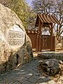
Wakamatsu Tea and Silk Colony Farm

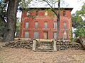
The Wakamatsu Tea and Silk Colony Farm in Gold Hill is a unique historic site. It was the first Japanese colony in America, founded in 1869. A group of Japanese immigrants came here to grow tea and silk, hoping to start a new life. While the colony didn't last long, it's an important part of California's history, showing early connections between Japan and the United States.
Historic Buildings in Placerville
Placerville, once known as "Hangtown" during the Gold Rush, has many historic buildings that are still standing today.
Old Commercial Buildings
Fountain-Tallman Soda Works

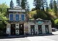
The Fountain-Tallman Soda Works and the John Pearson Soda Works are two historic buildings on Main Street in Placerville. These buildings were once places where soda water was made and sold. Imagine how refreshing a cold soda must have been for miners after a long day of work! They show us what everyday life was like in a Gold Rush town.
Confidence Hall

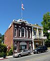
Confidence Hall on Main Street was a meeting place for a group called the Independent Order of Odd Fellows. These kinds of halls were important community centers in the 1800s, where people gathered for social events, meetings, and to help each other out.
Historic Homes and Churches
Combellack-Blair House

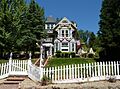
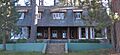
The Combellack-Blair House is a beautiful old home in Placerville. It represents the kind of houses built by successful people in the area during the late 1800s. Looking at these homes helps us understand the different lifestyles of people who lived in Gold Rush towns.
Episcopal Church of Our Saviour

The Episcopal Church of Our Saviour is a lovely old church building in Placerville. Churches were very important to communities, providing a place for worship and often serving as social hubs. This church has been a part of Placerville's history for many years.
Historic Estates by Lake Tahoe
Near the beautiful Lake Tahoe, several grand estates are also on the National Register of Historic Places. These estates show a different side of California's history, focusing on wealthy families who built summer homes by the lake.
The Pope, Baldwin, and Heller Estates


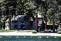
The Pope Estate, Baldwin Estate, and Heller Estate are three beautiful properties located near the junction of US 50 and CA 89 in South Lake Tahoe. These estates were built in the early 1900s as summer retreats for wealthy families from San Francisco. They feature grand houses, boathouses, and lovely gardens, showing the luxurious lifestyle of that era. Today, these estates are often open to the public for tours and events, allowing visitors to step back in time.
Vikingsholm

Vikingsholm is a truly unique mansion located on Emerald Bay in South Lake Tahoe. It was built in 1929 and designed to look like a Viking castle, complete with sod roofs and intricate carvings. The owner, Mrs. Lora Knight, loved Scandinavian architecture and wanted her summer home to reflect that. Vikingsholm is considered one of the finest examples of Scandinavian architecture in North America and is a popular spot for visitors to explore.
Other Notable Historic Places
Bayley Hotel

The Bayley Hotel is located north of Pilot Hill. This old hotel dates back to the Gold Rush era and served as a stopping point for travelers and miners. It's a reminder of the many inns and hotels that sprang up to serve the thousands of people moving through California during the mid-1800s.
Sugar Pine Point State Park

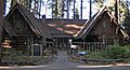
Ed Z'berg Sugar Pine Point State Park is a beautiful park located south of Homewood on Lake Tahoe. Besides its natural beauty, the park contains historic buildings, including the Hellman-Ehrman Mansion, which was built in 1903. This mansion and the surrounding parkland are recognized for their historical significance, showing how people enjoyed and developed the Lake Tahoe area over a century ago.
Images for kids
-
The historic Baldwin Estate near Lake Tahoe.
-
The historic Bayley Hotel in Pilot Hill.
-
The historic Combellack-Blair House in Placerville.
-
Confidence Hall, a historic meeting place in Placerville.
-
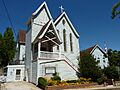
The Episcopal Church of Our Saviour in Placerville.
-
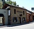
The Fountain-Tallman Soda Works building in Placerville.
-
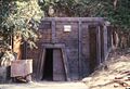
The entrance to the historic Gold Bug Mine in Placerville.
-
The boathouse on the Heller Estate.
-
The John Pearson Soda Works building in Placerville.
-
A view of the Pope Estate by Lake Tahoe.
-
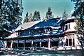
A view of Sugar Pine Point State Park.
-
Vikingsholm, a unique castle-like mansion on Emerald Bay.
-
The historic site of the Wakamatsu Tea and Silk Colony Farm.

