
National Register of Historic Places listings in Jefferson County, Alabama facts for kids

Did you know that many old buildings and places are super important for history? In Jefferson County, Alabama, there are lots of these special spots! They are listed on something called the National Register of Historic Places. This list helps protect these places so we can learn from them for many years.
Jefferson County has 171 places on this list. Three of them are even more special and are called National Historic Landmarks. Most of these amazing places (146 of them, including all the Landmarks) are in the city of Birmingham. They have their own separate list. This article will tell you about the other 26 cool places outside of Birmingham. One area, the Red Mountain Suburbs Historic District, actually includes parts of both Birmingham and nearby areas in Jefferson County.
Contents
Exploring Historic Places in Jefferson County
Historic Sites in Birmingham
To learn about the many historic places inside Birmingham, you can check out this separate list:
Historic Places Outside Birmingham
Here are some of the interesting historic buildings and areas you can find in Jefferson County, outside of Birmingham. Each one has a unique story!
| Name on the Register | Image | Date listed | Location | City or town | Description | |
|---|---|---|---|---|---|---|
| 1 | Jonathan W. Bass House |
 |
(#08000456) |
1129 Montevallo Rd. 33°32′25″N 86°33′29″W / 33.5403°N 86.557958°W |
Leeds | This historic house in Leeds was added to the National Register in 2008. It's a great example of old homes in the area. |
| 2 | Cahaba Homestead Village Historic District |
(#06000187) |
Approximately between Interstate 59 and U.S. Route 11 33°37′46″N 86°36′27″W / 33.629444°N 86.6075°W |
Trussville | This historic district in Trussville was added to the list in 2006. It includes a collection of important buildings. | |
| 3 | Canaan Baptist Church |
 |
(#05000290) |
824 15th St., N. 33°24′06″N 86°57′51″W / 33.401667°N 86.964167°W |
Bessemer | Canaan Baptist Church in Bessemer is a significant building. It was recognized for its historical importance in 2005. |
| 4 | Downtown Bessemer Historic District |
(#92000852) |
Roughly bounded by 21st St., N., Carolina Ave., 19th St., N., 5th Ave., N. and the former Southern railroad tracks 33°24′08″N 86°57′05″W / 33.402222°N 86.951389°W |
Bessemer | The downtown area of Bessemer is a historic district. It includes many buildings that show the city's past. It was listed in 1992. | |
| 5 | Dunbar High School |
 |
(#10001051) |
2715 6th Ave. N. 33°25′35″N 86°56′18″W / 33.426389°N 86.938333°W |
Bessemer | Dunbar High School in Bessemer is an important historic school building. It was added to the National Register in 2011. |
| 6 | Five Mile Creek Bridge |
(#73000350) |
1 mile northeast of McCalla off U.S. Route 11 33°21′07″N 87°01′19″W / 33.351944°N 87.021944°W |
McCalla | This old bridge near McCalla is a historic landmark. It was listed on the National Register in 1973. | |
| 7 | Flintridge Building |
 |
(#04000560) |
6200 E.J. Oliver Boulevard 33°28′33″N 86°55′09″W / 33.475833°N 86.919167°W |
Fairfield | The Flintridge Building in Fairfield is a notable historic structure. It was added to the list in 2004. |
| 8 | Hollywood Historic District |
(#02000482) |
Roughly bounded by U.S. Routes 31 and 280 and Lakeshore Dr. 33°28′47″N 86°46′54″W / 33.479722°N 86.781667°W |
Homewood | The Hollywood area of Homewood is a historic district. It was recognized in 2002 for its unique character. | |
| 9 | Leeds Downtown Historic District |
 |
(#94001546) |
Roughly bounded by 9th St., NE., Thornton and Railroad Aves., and Parkway Dr., SE. 33°32′34″N 86°32′21″W / 33.542778°N 86.539167°W |
Leeds | Downtown Leeds is a historic district with many old buildings. It was added to the National Register in 1995. |
| 10 | Thomas McAdory House |
(#72000161) |
214 Eastern Valley Rd. 33°22′11″N 86°57′52″W / 33.369722°N 86.964444°W |
Bessemer | The Thomas McAdory House in Bessemer is a historic home. It was listed on the National Register in 1972. | |
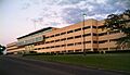
| 11 | Miles Memorial College Historic District |
 |
(#93001031) |
5501 Myron Massey Boulevard 33°28′53″N 86°54′28″W / 33.481389°N 86.907778°W |
Fairfield | This historic district is part of Miles College in Fairfield. It was added to the list in 1994. |
| 12 | Mountain Brook Estates Building |
(#03000232) |
2803 Cahaba Rd. 33°29′09″N 86°46′21″W / 33.485833°N 86.7725°W |
Mountain Brook | The Mountain Brook Estates Building is a historic site in Mountain Brook. It was listed in 2003. | |
| 13 | Owen Plantation House |
(#76000330) |
South of Bessemer on Eastern Valley Rd. 33°20′50″N 86°59′00″W / 33.347222°N 86.983333°W |
Bessemer | The Owen Plantation House near Bessemer is a historic property. It was added to the National Register in 1976. | |
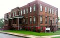
| 14 | Dr. Thomas McAdory Owen House |
 |
(#82002038) |
510 N. 18th St. 33°24′11″N 86°57′24″W / 33.403056°N 86.956667°W |
Bessemer | This house in Bessemer belonged to Dr. Thomas McAdory Owen. It became a historic site in 1982. |
| 15 | Parham Apothecary Building |
 |
(#96000595) |
401 60th St. 33°28′41″N 86°54′48″W / 33.478056°N 86.913333°W |
Fairfield | The Parham Apothecary Building in Fairfield is a historic pharmacy building. It was listed in 1996. |
| 16 | Pinson Hills Historic District |
(#15000975) |
Roughly Cedar, Church, Main, Mountain, Pinson & Walnut Sts., Pinewood & Leslie Drs., Center Point & Silver Lake Rds. 33°41′29″N 86°40′43″W / 33.6915°N 86.6785°W |
Pinson | Pinson Hills is a historic district in Pinson. It was added to the National Register in 2016. | |
| 17 | Pinson Main Street Historic District |
(#15000976) |
Roughly Clayton, Lane, Main & Spring Sts., Elm & Powell Aves., Marvin's Way, Old Bradford Rd. & Pinson Plz. 33°41′23″N 86°41′08″W / 33.689760°N 86.685570°W |
Pinson | The Main Street area of Pinson is another historic district. It was also listed in 2016. | |
| 18 | Red Mountain Suburbs Historic District |
(#85002719) |
Roughly bounded by Crest and Argyle and Altamont, Country Club, Salisbury, and Lanark Rds. 33°30′04″N 86°46′30″W / 33.501111°N 86.775°W |
Mountain Brook | This large historic district includes parts of Mountain Brook and extends into Birmingham. It was recognized in 1985. | |
| 19 | Redmont Garden Apartments |
(#93000761) |
2829 Thornhill Rd. 33°29′43″N 86°46′46″W / 33.495278°N 86.779444°W |
Mountain Brook | The Redmont Garden Apartments in Mountain Brook are part of a historic district. They were listed in 1993. | |
| 20 | Rosedale Historic District |
 |
(#04000236) |
Roughly bounded by 25th Court, S., Central Ave., 27th Court, S., Loveless/BM Montgomery St. 33°29′07″N 86°47′39″W / 33.485278°N 86.794167°W |
Homewood | The Rosedale Historic District in Homewood was added to the National Register in 2004. It shows the history of the neighborhood. |
| 21 | Rosedale Park Historic District |
 |
(#04000235) |
Roughly bounded by Woodcrest Place, 26th Ave., S., 18th St., S., and 25th Ct., S. 33°29′16″N 86°47′23″W / 33.487778°N 86.789722°W |
Homewood | Rosedale Park in Homewood is another historic district. It was also listed in 2004, preserving its unique past. |
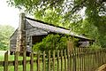
| 22 | Sadler House |
 |
(#75000315) |
3 miles south of McCalla on Eastern Valley Rd. 33°18′54″N 87°00′52″W / 33.315°N 87.014444°W |
McCalla | The Sadler House near McCalla is a historic home. It was added to the National Register in 1975. |
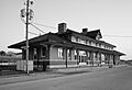
| 23 | Southern Railroad Depot |
 |
(#83002975) |
933 Thornton Ave., NE. 33°32′37″N 86°32′20″W / 33.543611°N 86.538889°W |
Leeds | The old Southern Railroad Depot in Leeds is a historic train station. It was listed in 1983. |
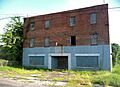
| 24 | Southern Railway Terminal Station |
.jpg) |
(#73000348) |
1905 Alabama Ave. 33°24′04″N 86°57′01″W / 33.401111°N 86.950278°W |
Bessemer | The Southern Railway Terminal Station in Bessemer is now the Bessemer Hall of History. It was listed in 1973. |
| 25 | Tarrant City Downtown Historic District |
(#09000105) |
Parts of E. Lake Blvd., Ford Ave., Jackson Blvd., Pinson St., Wharton Ave. 33°34′56″N 86°46′14″W / 33.582222°N 86.770556°W |
Tarrant | The downtown area of Tarrant City is a historic district. It was added to the National Register in 2010. |
Images for kids
-
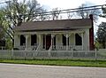
The Jonathan W. Bass House in Leeds.
-
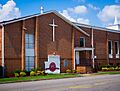
Canaan Baptist Church in Bessemer.
-
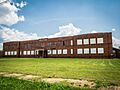
Dunbar High School in Bessemer.
-
The Flintridge Building in Fairfield.
-
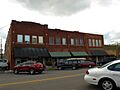
A building in the Leeds Downtown Historic District.
-
Williams Hall at Miles College in Fairfield.
-
The Dr. Thomas McAdory Owen House in Bessemer.
-
The Parham Apothecary Building in Fairfield.
-
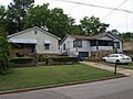
A building in the Rosedale Historic District in Homewood.
-
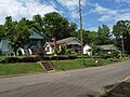
A building in the Rosedale Park Historic District in Homewood.
-
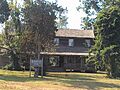
The Sadler House near McCalla.
-
The Southern Railroad Depot in Leeds.
-
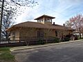
The Southern Railway Terminal Station in Bessemer.
