
National Register of Historic Places listings in Marion County, Kentucky facts for kids

Hey everyone! Did you know that some buildings and places are super important because of their history? They are so special that they get listed on something called the National Register of Historic Places. This list helps protect these cool spots across the United States.
This page is all about the amazing historic places right here in Marion County, Kentucky. There are 12 different places in our county that are on this important list. Each one has a unique story to tell about the past!
Contents
- What is the National Register of Historic Places?
- Historic Places in Marion County
- Bradfordsville Christian Church
- Burks' Distillery
- Gravel Switch Historic District
- Lebanon Historic Commercial District
- Lebanon Junior High School and Lebanon High School
- Lebanon National Cemetery
- Loretto Motherhouse
- Captain Andrew Offutt Monument
- Clel Purdom House
- St. Joseph Church
- St. Mary's College Historic District
- Leonard A. Spalding House
- Images for kids
What is the National Register of Historic Places?
The National Register of Historic Places is like a special club for buildings, sites, and objects that are important in American history. It's run by the National Park Service, which is part of the U.S. government. When a place is added to this list, it means it's recognized for its historical, architectural, archaeological, engineering, or cultural importance.
Being on the list helps protect these places. It can also make them eligible for grants or tax benefits to help keep them in good shape. It's a way to make sure these pieces of history stick around for a long, long time!
Historic Places in Marion County
Let's explore some of the cool historic spots you can find in Marion County:
Bradfordsville Christian Church
- Location: Bradfordsville
- Listed: October 25, 2010
This church is an important part of the Bradfordsville community's history. It has been a place for people to gather for many years.
Burks' Distillery
- Location: East of Loretto
- Listed: December 31, 1974
- Image:

This distillery is famous for making a special kind of Kentucky bourbon. It's not just a factory; it's a historic landmark that shows how important distilling has been to Kentucky's economy and culture.
Gravel Switch Historic District
- Location: Gravel Switch
- Listed: January 22, 2014
A "historic district" means a whole area or group of buildings is important. This district in Gravel Switch tells the story of how this community grew and changed over time.
Lebanon Historic Commercial District
- Location: Lebanon
- Listed: November 10, 1987
- Image:

This district covers the main business area of Lebanon. It includes many old buildings that show what shopping and town life were like in the past. Imagine all the stories these streets could tell!
Lebanon Junior High School and Lebanon High School
- Location: Lebanon
- Listed: March 31, 2000
- Image:

These school buildings have seen many students come and go over the years. They are important because of their architecture and their role in educating generations of Marion County kids.
Lebanon National Cemetery
- Location: Southwest of Lebanon
- Listed: June 5, 1975
- Image:

This cemetery is a special place where soldiers who served our country are laid to rest. It's a quiet and respectful place that honors their bravery and sacrifice.
Loretto Motherhouse
- Location: Nerinx
- Listed: April 2, 1980
The Loretto Motherhouse is the main center for the Sisters of Loretto, a group of Catholic sisters. It's a very old and important religious site with beautiful buildings and a long history of education and service.
Captain Andrew Offutt Monument
- Location: Ryder Cemetery, east of Lebanon
- Listed: July 17, 1997
- Image:

This monument honors Captain Andrew Offutt, an important figure from the past. Monuments like this help us remember people who made a difference in history.
Clel Purdom House
- Location: Lebanon
- Listed: February 11, 2016
This house is a great example of the architecture from its time. It shows us how people lived and built their homes many years ago.
St. Joseph Church
- Location: Raywick
- Listed: October 25, 2010
Just like the Bradfordsville Christian Church, St. Joseph Church has been a central part of the Raywick community for a long time. It's a place of worship with historical significance.
St. Mary's College Historic District
- Location: South of St. Mary
- Listed: April 10, 1980
This historic district includes buildings that were once part of St. Mary's College. It played an important role in education in the region.
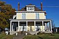
Leonard A. Spalding House
- Location: Lebanon
- Listed: April 3, 1991
- Image:

This house is named after Leonard A. Spalding, a notable person from Lebanon's past. It's another example of the interesting architecture found in Marion County.
Images for kids
-
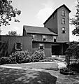
The famous Burks' Distillery, also known as Maker's Mark.
-
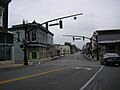
A view of downtown Lebanon, Kentucky.
-
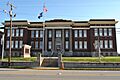
The historic Lebanon High School building.
-

Headstones at Lebanon National Cemetery.
-
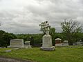
The monument dedicated to Captain Andrew Offutt.
-
The historic Leonard A. Spalding House.
