
National Register of Historic Places listings in Milwaukee facts for kids
The City of Milwaukee in Wisconsin is home to many special places listed on the National Register of Historic Places. This list includes all sorts of historic spots like buildings, sites, structures, historic neighborhoods, and even unique objects.
There are 278 historic places listed in Milwaukee County, Wisconsin. Out of these, 206 are right here in the city of Milwaukee, and 72 are in other parts of Milwaukee County. One place that was once on the list in the city has since been removed.
Contents
What is the National Register of Historic Places?
The National Register of Historic Places (NRHP) is the official list of places in the United States that are important to our country's history. These places could be buildings, neighborhoods, or even old battlefields. When a place is added to the NRHP, it means it's recognized for its special history, architecture, or culture. This helps protect these places and makes people more aware of their importance.
Historic Places in Milwaukee
Milwaukee has many amazing historic places. Let's explore some of them!
Buildings and Homes
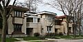
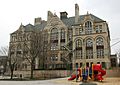
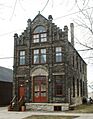
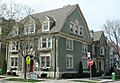
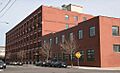
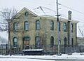
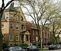
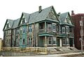
- Abbot Row (1019-1043 E. Ogden Ave.): This apartment building was designed by Howland Russel in 1889. It's a great example of the Queen Anne style, which was popular back then.
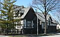
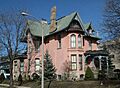
- Charles Abresch House (2126 W. Juneau Ave.): Built in 1890, this is a beautiful Victorian-style home.
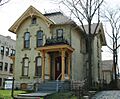
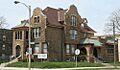
- Emanuel D. Adler House (1681 N. Prospect Ave.): This Victorian home belonged to a clothing maker and was built in 1888. A.C. Clas was the architect.
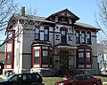
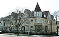
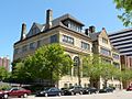
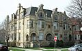
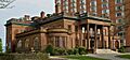
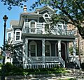
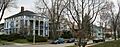
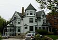
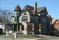
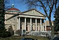
- Charles Allis House (1630 E. Royall Pl.): This grand Tudor-style mansion was built in 1911 for Charles Allis. It was designed by Alexander Eschweiler. Today, it's the Charles Allis Art Museum!
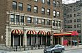
- Astor on the Lake (924 E. Juneau Ave.): This building was a Classical Revival hotel built in 1920.
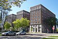
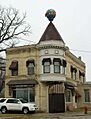
- Baasen House-German YMCA (1702 N. 4th St.): Designed by Charles Gombert in 1874, this building has a rich history.
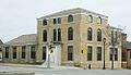
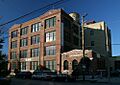
- Baumbach Building (302 N. Broadway St.): This building was constructed in 1900 for a men's clothing company.
- Frederick C. Bogk House (2420 N. Terrace Ave.): This house was designed by the famous architect Frank Lloyd Wright in 1917.
- Herman W. Buemming House (1012 E. Pleasant St.): A Greek Revival style house built in 1901.
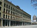
- J. L. Burnham Block (907-911 W. National Ave.): This building shows early Italianate commercial architecture and was built by a brickmaker named J.L. Burnham.
- Elias A. Calkins Doublehouse (1612-1614 E. Kane Pl.): A historic doublehouse.
- Michael Carpenter House (1115 Thirty-fifth St.): Another historic home in the West Side Area.
- Thomas Cook House (853 N. Seventeenth St.): This house is also part of the West Side Area's historic places.
- Edward J. Dahinden House (3316 W. Wisconsin Ave.): A historic home in the West Side Area.
- Desmond-Farnham-Hustis House (1535 N. Marshall St.): A historic house.
- Abraham H. Esbenshade House (3119 W. Wells St.): This house is part of the West Side Area.
- Exton Apartments Building (1260 N. Prospect Ave.): This nine-story Art Deco apartment building was designed by Herbert Tullgren in 1938.
- Otto F. Fiebing House (302 N. Hawley Rd.): This house is part of a group of stone masonry houses designed by Ernest Flagg.
- Christian Foth House (1209-1211 S. Seventh St.): A historic house.
- Friedmann Row (1537, 1539, 1541, 1543 N. Cass St. and 731 E. Pleasant St.): A row of historic buildings.
- Alfred M. Hoelz House (3449-3451 Frederick Ave.): Another house that is part of the Ernest Flagg Stone Masonry Houses group.
- David W. Howie House (3026 W. Wells St.): This home is part of the West Side Area.
- Joseph B. Kalvelage House (2432 W. Kilbourn Ave.): A German baroque house built in 1897.
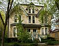
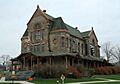
- Sanford R. Kane House (1841 N. Prospect Ave.): This large Queen Anne style mansion was built in 1883.
- Knapp-Astor House (930 E. Knapp St. and 1301 N. Astor St.): A historic house.
- Koelsch Funeral Home (7622 W, Greenfield Ave.): A historic funeral home.
- Robert Machek House (1305 N. 19th St.): A historic house.
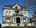
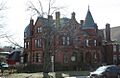
- McIntosh-Goodrich Mansion (1584 N. Prospect Ave.): This Classical Revival mansion was designed by H.R. Wilson in 1932.
- Alexander Mitchell House (900 W. Wisconsin Ave.): A historic mansion.
- New Coeln House (5905 S. Howell Ave.): A historic house.
- Joseph B. Oliver House (1516 E. Brady St.): A historic house.
- George W. Peck Row House (1620-1630 N. Farwell Ave.): A historic row house.
- Charles Quarles House (2531 N. Farwell Ave.): A historic house.
- Fred Sivyer House (761 N. 25th St.): This house is part of the West Side Area.
- Lloyd R. Smith House (2220 N. Terrace Ave.): This beautiful Italian villa-style home was built in 1924 and overlooks Lake Michigan. Today, it's the Villa Terrace Decorative Arts Museum.
- William Steinmeyer House (1716-1722 N. 5th St.): This house is part of the Brewers' Hill area.
- Harry B. Walker House (3130 W. Wells St.): This home is part of the West Side Area.
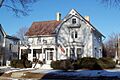
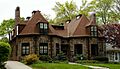
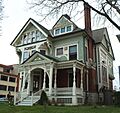
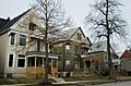
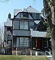
- George Schuster House and Carriage Shed (3209 W. Wells St.): This bright red eclectic-style home and its carriage barn were built in 1891. It's part of the West Side Area.
Churches and Religious Sites
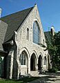
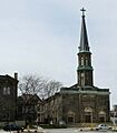
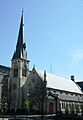
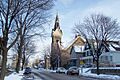
- All Saints' Episcopal Cathedral Complex (804-828 E. Juneau Ave.): This church was designed in 1868 in the Gothic Revival style by E. Townsend Mix. It was originally called Olivet Congregational Church.
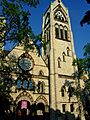
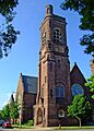
- Calvary Presbyterian Church (935 W. Wisconsin Ave.): This Gothic Revival church was designed by Henry C. Koch & Hess and built in 1870. It has a huge corner tower!
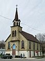
- Christ Evangelical Lutheran Church (2235 W. Greenfield Ave.): Designed by Frederick Velguth, this Gothic Revival church was built in 1901.
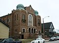
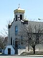
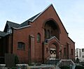
- Congregation Beth Israel Synagogue (2432 N. Teutonia Ave.): This synagogue was built in 1925. In 1960, it was sold and became the Greater Galilee Missionary Baptist Church.
- First Church of Christ, Scientist (1443-1451 N. Prospect Ave.): A historic church building.
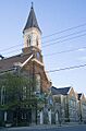
- First Unitarian Church (1009 E. Ogden Ave.): This Gothic Revival church was built in 1892 by architects Ferry and Class.
- Gesu Church (1145 W. Wisconsin Ave.): This church has twin spires and is built in the Gothic style. It's part of the West Side Area.
- Grand Avenue Congregational Church (2133 W. Wisconsin Ave.): This church is part of the West Side Area.
- Highland Avenue Methodist Church (2024 W. Highland Ave.): This church is part of the West Side Area.
- Holy Trinity Roman Catholic Church (605 S. 4th St.): A historic Catholic church.
- Immanuel Presbyterian Church (1100 N. Astor St.): Designed by E. Townsend Mix, this Gothic Revival church was built in 1873 using buff-colored limestone.
- Old St. Mary's Church (844 N. Broadway): This was Milwaukee's first German Catholic church, built in the Zopfstil style in 1847.
- St. George Melkite Catholic Church (1617 W. State St.): This church is a great example of Byzantine Revival architecture in the city. It shows how different cultures influenced building design. It's part of the West Side Area.
- St. James Episcopal Church (833 W. Wisconsin Ave.): A historic Episcopal church.
- St. John's Evangelical Lutheran Church Complex (804-816 W. Vliet St.): This Gothic Revival church was designed by Hermann Schnetzky in 1889.
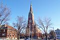
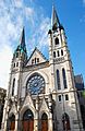
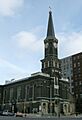
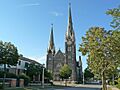
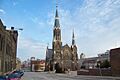
- St. John's Roman Catholic Cathedral (812 N. Jackson St.): This cathedral was built between 1847 and 1852 in the Zopfstil style.
- St. Josaphat Basilica (601 W. Lincoln Ave.): This grand church was built in 1901 and became the third basilica in the U.S. in 1929.
- St. Martini Evangelical Lutheran Church (1557 W. Orchard St.): A historic Lutheran church.
- St. Patrick's Roman Catholic Church (1105 S. 7th St.): A historic Catholic church.
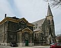
- St. Paul's Episcopal Church (904 E. Knapp St.): This Romanesque Revival style church, built from 1882-1890, is famous for its beautiful Tiffany windows. It was designed by local architect E. Townsend Mix.
- Saint Peter's Evangelical Lutheran Church (1204, 1213, 1214, and 1215 S. Eighth St.): Designed by Andrew Elleson, this church was completed in 1885 in the Italianate Gothic Revival style.
- Saints Peter and Paul Roman Catholic Church Complex (2474 and 2490 N. Cramer St. and 2479 and 2491 N. Murray Ave.): A complex of historic church buildings.
- Salem Evangelical Church (1025 & 1037 S. Eleventh St.): A historic Evangelical church.
- Sixth Church of Christ, Scientist (1036 N. Van Buren St.): A historic church building.
- Trinity Evangelical Lutheran Church (1046 N. 9th St.): This church was designed by Frederick Velguth in 1878, combining German Romanesque and Gothic Revival styles.
Schools and Public Buildings
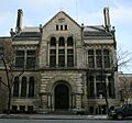
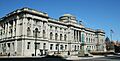
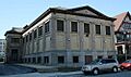
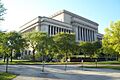
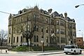
- Central Library (814 W. Wisconsin Ave.): This beautiful Renaissance-style library was designed by Ferry and Clas and built in 1895.
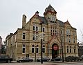
- Chief Lippert Fire Station (642 W. North Ave.): This firehouse was built in 1876.
- Dover Street School and Social Center (619 E. Dover St.): A historic school and social center.
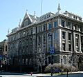
- Federal Building (515-519 E. Wisconsin Ave.): This Richardsonian Romanesque federal building and courthouse was built in the 1890s.
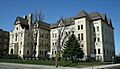
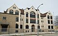
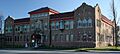
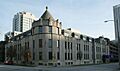
- German-English Academy (1020 N. Broadway): This Romanesque Revival school was built in 1891-92. It was started by German immigrants to teach German language and culture.
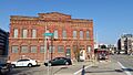
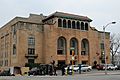
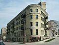
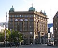
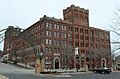
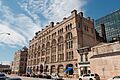
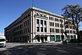
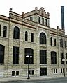
- Germania Building (135 W. Wells St.): Built in 1896, this was once the largest office building in Milwaukee and home to Germania Publishing Company.
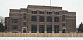
- Golda Meir School (333 W. Galena St.): This school was attended by Golda Meir, who later became the Prime Minister of Israel, from 1906 to 1912.
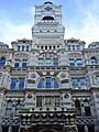
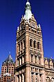
- Milwaukee City Hall (200 E. Wells St.): Designed by Henry C. Koch, this amazing Flemish Revival building was built in 1894. From 1895 to 1901, it was the tallest building in the U.S. outside of New York City!
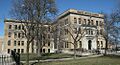
- Milwaukee County Courthouse (901 N. 9th St.): This huge Classical Revival courthouse was built in 1931.
- Milwaukee County Dispensary and Emergency Hospital (2430 W. Wisconsin Ave.): A historic hospital building.
- Milwaukee County Historical Center (910 N. 3rd St.): This building was a Neo-Classical bank built in 1913 and now houses the Milwaukee County Historical Center.
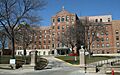
- Milwaukee Hospital (2200 W. Kilbourn Ave.): Founded in 1863, this was the first Protestant hospital west of Pittsburgh.
- Milwaukee Normal School-Milwaukee Girls' Trade and Technical High School (1820 W. Wells St.): This school is part of the West Side Area.
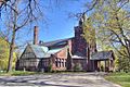
- Northwestern Branch, National Home for Disabled Volunteer Soldiers Historic District (5000 W. National Ave.): This important site features a cream city brick building in the Gothic Revival style, designed by E. Townsend Mix in 1867. It was one of the first city parks and is now a National Historic Landmark.
- Home Office, Northwestern Mutual Life Insurance Company (605-623 N. Broadway): The historic office building for this insurance company.
- Peckham Junior High School (3245 N. 37th St.): A historic junior high school.
- Public School No. 27 (2215 N. 4th St.): This school is part of the Brewers' Hill area.
- Public Service Building (231 W. Michigan St.): Built in 1902, this was the home of the first unified electric power company in the nation, which is now Wisconsin Energy Corporation.
- Saint Vincent's Infant Asylum (809 W. Greenfield Ave.): A historic infant asylum.
- South Branch Library (931 W. Madison St.): A historic library branch.
- Spencerian Business College (2800 W Wright St.): This college, founded in 1863, was a distinguished place for business training.
- State Bank of Wisconsin (210 E. Michigan St.): A historic bank building.
- Ward Memorial Hall (5000 W. National Ave.): Opened in 1882, this is one of the oldest theaters in Wisconsin.
- Wisconsin Consistory Building (790 N. Van Buren St.): A historic building.
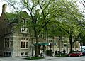
- Woman's Club of Wisconsin (813 E. Kilbourn Ave.): This is the oldest woman's clubhouse in the United States, built in 1887 and designed by Ferry & Clas.
Businesses and Factories
- Valentin Blatz Brewing Company (1101-1147 N. Broadway): A historic brewery from 1891.
- Valentin Blatz Brewing Company Office Building (1120 N. Broadway): The offices for the Blatz Brewery, built in 1890.
- Gimbels Parking Pavilion (555 N. Plankinton Ave.): This Art moderne building is a monument to how people started moving to the suburbs after World War II.
- Goodwill Industries Building (2102 W. Pierce St.): This building was a training center for people with disabilities.
- Harley-Davidson Motorcycle Factory Building (3700 W. Juneau Ave.): This factory building is part of the West Side Area.
- Frederick Ketter Warehouse (325 W. Vine St.): This warehouse is part of the Brewers' Hill area.
- Lindsay-Bostrom Building (133 W. Oregon St.): A historic building.
- Lohman Funeral Home and Livery Stable (804 W. Greenfield and 1325 S. Eighth): A historic funeral home and stable.
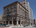
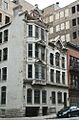
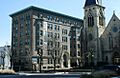
- Mackie Building (225 E. Michigan St.): This Victorian landmark, designed by E. Townsend Mix in 1879, was once the world’s largest grain exchange.
- George C. Mansfield Company Building (1300 N. 4th St.): A historic company building.
- Mayer Boot and Shoe Company Building (116 E. Walnut St.): This building is part of the Brewers' Hill area.
- Milwaukee Fire Department High Pressure Pumping Station (2011 S. 1st St.): A historic pumping station for the fire department.
- Milwaukee News Building and Milwaukee Abstract Association Building (222 E. Mason St.): Historic buildings.
- Milwaukee Paper Box Company (1560 W. Pierce St.): A historic paper box company building.
- Milwaukee-Western Fuel Company Building (2150 N. Prospect Ave.): This Art Deco office building was designed by Herbert Tullgren in 1934.
- Mitchell Building (207 E. Michigan St.): This 1876 office building was designed by E. Townsend Mix in the French Second Empire style.
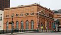
- Oneida Street Station (108 E. Wells and 816 N. Edison Sts.): This station was notable for being the first to use pulverized coal in its boilers in 1919.
- Pabst Brewery Saloon (1338-1340 W. Juneau Ave.): This saloon is part of the West Side Area.
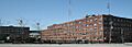
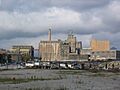
- Pabst Brewing Company Complex (Roughly bounded by Highland Ave., 11th, Winnebago and 9th Sts.): This brewing company was founded in 1844 and was once the largest brewer in the world!
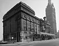
- Pabst Theater (144 E. Wells St.): Built in 1895, this theater was very advanced for its time.
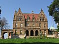
- Frederick Pabst House (2000 W. Wisconsin Ave.): This amazing Flemish Renaissance Revival mansion was built in 1892 for beer baron Captain Frederick Pabst.
- Pittsburgh Plate Glass Enamel Plant (201 E. Pittsburgh Ave.): An Art Deco factory and office building.
- John Pritzlaff Hardware Company (305-333 N. Plankinton & 143, 155, W. St. Paul Aves.): This building was the home of Milwaukee's largest hardware company, built in 1875.
- Pythian Castle Lodge (1925 W. National Ave.): This Spanish Colonial Revival-style lodge for the Knights of Pythias was built in 1927.
- Joseph Schlitz Brewing Company Saloon (2414 S. St. Clair St.): A historic saloon.
- Joseph Schlitz Company Brewery Complex (219 W. Galena St.): The historic brewery complex for Joseph Schlitz.
- Victor Schlitz House (2004 W. Highland Ave.): Designed by Charles Gombert in 1890, this house is part of the West Side Area.
- Square D Company-Industrial Controller Division (710 S. 3rd St.): A historic industrial building.
- Wisconsin Leather Company Building (320 E. Clybourn St.): Built in 1874, this building was designed by E. Townsend Mix.
Parks and Outdoor Spaces
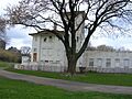
- Forest Home Cemetery (2405 Forest Home Ave.): Founded in 1850, this is the resting place for many important people from Milwaukee.
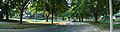
- Kinnickinnic River Parkway (Between S. 72nd & S. 16th Sts.): Part of Milwaukee County's parkway system.
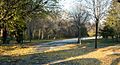
- Lake Park (2900 N. Lake Dr. and 2800 E. Kenwood Blvd.): This park was designed by the famous landscape architect Frederick Law Olmsted and started in the 1890s.
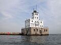
- Milwaukee Breakwater Light (South end of the north breakwater, 0.7 mi east of the mouth of the Milwaukee River): This lighthouse is part of a group of historic light stations in the United States.
- Milwaukee River Parkway (Between Good Hope Rd. & W. Capitol Dr.): Another part of the Milwaukee County Parkway System.
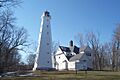
- North Point Light (Wahl St. at Terrace): This lighthouse was first established in 1855, with the current structure built in 1888 and 1913. It's part of the U.S. Coast Guard Lighthouses on the Great Lakes.
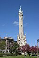
- North Point Water Tower (E. North Ave. between N. Lake Dr. and N. Terrace Ave.): This 175-foot Victorian Gothic tower was designed by Charles Gombert and built in 1873 to help regulate water pressure.
Historic Neighborhoods and Districts
- 27th and Wells Streets Commercial Historic District (757, 760, 800-810, 801-813, 817-831, 820-826 N.27th St., 2632, 2711 W. Wells St.): A historic commercial area.
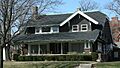
- American System Built Homes-Burnham Street District (W. Burnham St.): These affordable homes were designed by Frank Lloyd Wright and built in 1915.
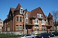
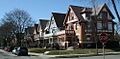
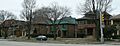
- Bay View Historic District (Roughly bounded by Lake Michigan, Meredith, Superior, Nock, Wentworth, Pryor, Clair, RR tracks and Conway St.): A residential neighborhood from 1867.
- Brewers Hill Historic District (Vine, Reservoir, Palmer, 1st, 2nd, and Brown Sts.): This area is part of the Brewers' Hill historic group.
- Cass-Juneau Street Historic District (Roughly bounded by E. Knapp and Marshall Sts., Juneau Ave., and Van Buren St.): A historic district.
- Cass-Wells Street Historic District (712, 718, and 724 E. Wells St. and 801, 809, 815, 819, and 823 N. Cass St.): A historic district.
- Concordia Historic District (Roughly bounded by West State, N. 27th, W. Killbourn Ave. and N. 35th St.): This district is part of the West Side Area.
- East Brady Street Historic District (E. Brady St. from N. Farwell Ave. to N. Van Buren St.): This area became a commercial center for the Polish neighborhood starting in 1865.
- East Oregon and South Barclay Industrial Historic District (300 S. Barclay, 139, 221 E. Oregon & 214 E. Florida Sts.): A historic industrial area.
- East Side Commercial Historic District (Roughly bounded by E. Wells St., N. Jefferson St. and N. Broadway, Michigan and E. Clybourn, and N. Water Sts.): A historic commercial district.
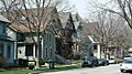
- East Village Historic District (Generally bounded by North Humboldt, East Brady, North Warren and Milwaukee R): A working-class residential neighborhood.
- First Ward Triangle Historic District (Roughly Franklin Pl., N. Prospect and E. Juneau Aves., and E. Knapp St.): A historic district.
- Florida and Third Industrial Historic District (234-500 (N side) W. Florida St., 222 W. Pittsburgh Ave., 212, 222, 305, 331 S. Third St., 400 S. Fifth St.): This district includes industrial properties built between 1891 and 1928.
- Gallun Tannery Historic District (Holton and Water Sts.): This district is part of the Brewers' Hill area.
- Garden Homes Historic District (Roughly bounded by W. Ruby and N. Teutonia Aves., N. 24th Pl., W. Atkinson Ave. and N. 27th St.): A historic district.
- Highland Boulevard Historic District (W. Highland Blvd. roughly bounded by N. 33rd and N. 29th Sts.): This district is part of the West Side Area.
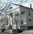
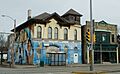
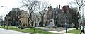
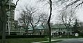
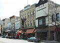
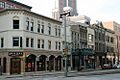
- Historic Third Ward District (Bounded by the Milwaukee River, C&NW RR, and E. St. Paul and N. Jackson Sts.): This neighborhood was first settled by Irish people and later became known for its Italian businesses.
- Kenwood Park-Prospect Hill Historic District (Roughly bounded by N. Hackett Ave., E. Edgewood Ave., N. Lake Dr. and E. Newberry Ave.): A historic district.
- Kilbourn Avenue Row House Historic District (Roughly bounded by N. 14th St., W. Kilbourn Ave., and N. 15th St.): This district is part of the West Side Area.
- McKinley Boulevard Historic District (W. McKinley Blvd. between N. 34th & N. 27th Sts.): This district is part of the West Side Area.
- Newberry Boulevard Historic District (1802-3000 E. Newberry Blvd.): A historic district.
- North 47th Street Bungalow Historic District (2500 block of N. 47th St. between Wright and Clarke Sts.): A historic district known for its bungalow-style homes.
- North First Street Historic District (Roughly 1st and 2nd Sts. between North and Center Sts.): This district is part of the Brewers' Hill area.
- North Grant Boulevard Historic District (2370-2879 N. Grant Blvd.): An upscale neighborhood developed between 1913 and 1931.
- North Point North Historic District (Roughly bounded by N. Downer Ave., E. Park Pl., and N. Wahl Ave.): A historic district.
- North Point South Historic District (Roughly bounded by North Ave., Summit, Terrace, and Lafayette Sts.): A historic district.
- North Sherman Boulevard Historic District (N. Sherman Blvd. Roughly bounded by W. Keefe Ave. and W. Lisbon Ave.): A historic district.
- North Third Street Historic District (Roughly N. 3rd St. between N. 3rd Ave. and Vine St.): This district is part of the Brewers' Hill area.
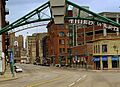
- Old World Third Street Historic District (N. Old World Third St., W. Highland Ave., and W. State St.): A historic district.
- Plankinton-Wells-Water Street Historic District (Roughly bounded by Wells, Bridge, N. Water, E. Mason, W. Wells, and N. Second Sts.): A historic district.
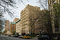
- Prospect Avenue Apartment Buildings Historic District (N. Prospect Ave. area roughly between E. Kane Pl. and E. Windsor St.): A historic district known for its apartment buildings.
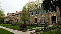
- Prospect Avenue Mansions Historic District (1363-1551 N. Prospect Ave.): A historic district with many mansions.
- Prospect Hill Historic District (2700 block of N. Hackett Ave., N. Shepard Ave., N. Summit Ave. and 2804-06 E. Park Place): A historic district.
- South First and Second Street Historic District (Roughly bounded by Menomonee River, Chicago & N. Western RR, Seeboth, S. First, Oregon, & S. Second Sts.): A historic district.
- South Layton Boulevard Historic District (921-2264 S. Layton Blvd.): A historic district.
- Walker's Point Historic District (Roughly bounded by the Freeway, Scott, 2nd, and W. Virginia Street): A historic district.
- West Side Commercial Historic District (Roughly, W. Wisconsin Ave., N. Third St., N. Plankinton Ave, and N. 2nd St.): A historic commercial district.
- West Washington-North Hi-Mount Boulevards Historic District (4701-5929 W. Washington Blvd.; 1720-2049 N. Hi-Mount Blvd.): A historic district.
Other Interesting Places
- Eagles Club (2401 W. Wisconsin Ave.): This building, with its 1920s ballroom, belonged to the Fraternal Order of Eagles. It's part of the West Side Area.
- Graham Row (1501, 1503, and 1507 N. Marshall St.): A historic row of buildings.
- Kilbourn Masonic Temple (827 N. Eleventh St.): This temple is part of the West Side Area.
- LIGHT VESSEL NO. 57 (Shipwreck): This is a historic shipwreck.
- Schoonmaker Reef (North of West St., between N. 66th St. and N. 64th St. extended): In 1862, this fossilized reef was discovered, and it was one of the first in the world to be identified as such!
- Soldiers' Home Reef (Northeast of the junction of Wood Ave. and General Mitchell Blvd., Clement J. Zablocki Veterans Affairs Medical Center grounds): Another fossilized reef discovered in 1862, also one of the first identified.
- Spring Grove Site (Address Restricted): A historic site.
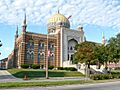
- Tripoli Temple (3000 W. Wisconsin Ave.): This Moorish Revival Shrine Center was built in 1928 and is loosely based on the famous Taj Mahal. It's part of the West Side Area.
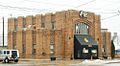
- Turner Hall (1034 N. 4th St.): Designed by Henry C. Koch in 1882, this was a meeting place for the Turners, a German-American group focused on social, political, and gymnastic activities. It's a National Historic Landmark.
Places No Longer Listed
Sometimes, a historic place might be removed from the National Register of Historic Places. This can happen if the building is changed too much, or if it's destroyed.
- Old Coast Guard Station (1600 North Lincoln Memorial Drive): This building was listed in 1989 but was removed from the list in 2009.
Images for kids
-
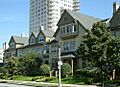
Abbot Row
-
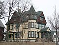
Charles Abresch House
-
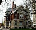
Emanuel D. Adler House
-

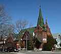
All Saints' Episcopal Cathedral Complex
-
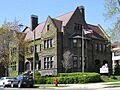
Charles Allis House
-
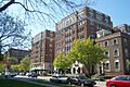
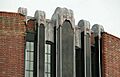
American System-Built Homes
-
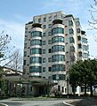
Astor on the Lake
-
Baasen House-German YMCA
-
Baumbach Building
-
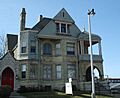
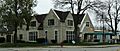
Beulah Brinton House (part of Bay View Historic District)
-
Valentin Blatz Brewing Company
-
Valentin Blatz Brewing Company Office Building
-
Frederick C. Bogk House
-
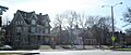
Brewers Hill Historic District
-
Herman W. Buemming House
-
J. L. Burnham Block
-
Elias A. Calkins Doublehouse
-
Calvary Presbyterian Church
-
Michael Carpenter House
-
Cass-Juneau Street Historic District
-
Cass-Wells Street Historic District
-
Central Library
-
Chief Lippert Fire Station
-
Christ Evangelical Lutheran Church
-

Concordia Historic District
-
Congregation Beth Israel Synagogue
-
Thomas Cook House
-
Edward J. Dahinden House
-
Desmond-Farnham-Hustis House
-
Eagles Club
-
East Brady Street Historic District
-
East Side Commercial Historic District
-
East Village Historic District
-
Abraham H. Esbenshade House
-
Exton Apartments Building
-
Federal Building
-
Otto F. Fiebing House
-
First Church of Christ, Scientist
-
First Unitarian Church
-
Burns Commons Park (part of First Ward Triangle Historic District)
-
Florida and Third Industrial Historic District
-
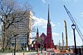
Landmark Chapel (part of Forest Home Cemetery)
-
Golda Meir School
-
Friedmann Row
-
Gallun Tannery Historic District
-
Garden Homes Historic District
-
German-English Academy
-
Germania Building
-
Gesu Church
-
Gimbels Parking Pavilion
-
Goodwill Industries Building
-
Graham Row
-

Grand Avenue Congregational Church
-
Thomas A. Greene Memorial Museum
-
Harley-Davidson Motorcycle Factory Building
-
Highland Avenue Methodist Church
-
Highland Boulevard Historic District
-
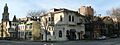
Historic Third Ward District
-
Alfred M. Hoelz House
-
Holy Trinity Roman Catholic Church
-
David W. Howie House
-
Immanuel Presbyterian Church
-
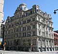
Iron Block Building
-
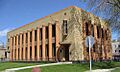
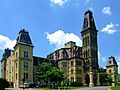
Johnston Hall
-
Joseph B. Kalvelage House
-
Sanford R. Kane House
-
Kenwood Park-Prospect Hill Historic District
-
Frederick Ketter Warehouse
-
Kilbourn Avenue Row House Historic District
-
Kilbourn Masonic Temple
-
Kinnickinnic River Parkway
-
Knapp-Astor House
-
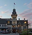
Knickerbocker Hotel
-
Koelsch Funeral Home
-
Lake Park
-
Lindsay-Bostrom Building
-
Lohman Funeral Home and Livery Stable
-
Robert Machek House
-
Mackie Building
-
Mayer Boot and Shoe Company Building
-
McIntosh-Goodrich Mansion
-
McKinley Boulevard Historic District
-
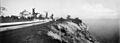
Milwaukee Breakwater Light
-
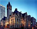
Milwaukee City Hall
-
Milwaukee County Courthouse
-
Milwaukee County Dispensary and Emergency Hospital
-
Milwaukee County Historical Center
-
Milwaukee Fire Department High Pressure Pumping Station
-
Milwaukee Hospital
-
Milwaukee News Building and Milwaukee Abstract Association Building
-
Milwaukee Normal School-Milwaukee Girls' Trade and Technical High School
-
Milwaukee-Western Fuel Company Building
-
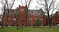
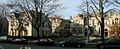
Milwaukee-Downer "Quad"
-
Mitchell Building
-
Alexander Mitchell House
-
New Coeln House
-
Newberry Boulevard Historic District
-
North First Street Historic District
-
North Grant Boulevard Historic District
-
North Point Lighthouse
-
North Point North Historic District
-
North Point South Historic District
-
North Point Water Tower
-
North Sherman Boulevard Historic District
-

North Third Street Historic District
-
Northwestern Branch, National Home for Disabled Volunteer Soldiers Historic District
-
Home Office, Northwestern Mutual Life Insurance Company
-
Old St. Mary's Church
-
Old World Third Street Historic District
-
Joseph B. Oliver House
-
Oneida Street Station
-
Pabst Brewery Saloon
-
Pabst Brewing Company Complex
-
Pabst Theater
-
Frederick Pabst House
-
Peckham Junior High School
-
Pittsburgh Plate Glass Enamel Plant
-
Plankinton-Wells-Water Street Historic District
-
John Pritzlaff Hardware Company
-
Prospect Avenue Apartment Buildings Historic District
-
Prospect Avenue Mansions Historic District
-
Prospect Hill Historic District
-
Public School No. 27
-
Public Service Building
-
Pythian Castle Lodge
-
Charles Quarles House
-
St. George Melkite Catholic Church
-
Saint James Court Apartments
-
St. James Episcopal Church
-
St. John's Evangelical Lutheran Church Complex
-

Cathedral of St. John the Evangelist
-

St. Josaphat Basilica
-
St. Patrick's Roman Catholic Church
-
St. Paul's Episcopal Church
-
Saint Peter's Evangelical Lutheran Church
-
Saint Vincent's Infant Asylum
-
Saints Peter and Paul Roman Catholic Church Complex
-
Salem Evangelical Church
-
Joseph Schlitz Brewing Company Saloon
-
Joseph Schlitz Company Brewery Complex
-
Victor Schlitz House
-

Schoonmaker Reef
-
George Schuster House and Carriage Shed
-
Second Church of Christ Scientist
-
Shorecrest Hotel
-
Fred Sivyer House
-
Sixth Church of Christ, Scientist
-

Lloyd R. Smith House
-
Soldiers' Home Reef
-
South First and Second Street Historic District
-
Spencerian Business College
-
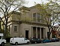
State Bank of Wisconsin
-
William Steinmeyer House
-
Trinity Evangelical Lutheran Church
-
Tripoli Shrine Temple
-
Turner Hall
-
Harry B. Walker House
-
Walker's Point Historic District
-
Ward Memorial Hall
-
West Side Commercial Historic District
-
West Washington-North Hi-Mount Boulevards Historic District
-
Wisconsin Consistory Building
-

Wisconsin Leather Company Building
-
Woman's Club of Wisconsin
-
Old Coast Guard Station


.jpg)


