
National Register of Historic Places listings in Modoc County, California facts for kids

Have you ever wondered about old buildings, special places, or even ancient sites that are important to history? In Modoc County, California, there's a list of these amazing spots! They are all part of something called the National Register of Historic Places. This is a special list in the United States that helps protect places that are important for their history, architecture, or what they teach us about the past.
Modoc County has 18 different places on this list. One of them is even a "National Historic Landmark," which means it's extra important to the whole country! Let's explore some of these cool historic spots.
Contents
What is the National Register of Historic Places?
The National Register of Historic Places is like a special club for buildings, sites, and objects that have a lot of history. It's managed by the National Park Service. When a place is added to this list, it means it's recognized as important to the history of a state or even the entire country. This helps protect these places so they can be enjoyed and learned from for many years to come.
Why are these places important?
These historic places help us understand how people lived in the past. They show us old ways of building, tell stories about important events, or even reveal clues about ancient cultures. Protecting them means we don't lose these valuable pieces of our history.
Historic Buildings in Modoc County
Modoc County has several buildings that are on the National Register. These buildings often show us what life was like long ago.
Adin Supply Company
The Adin Supply Company building is in the town of Adin. It was added to the list in 1997. This old building shows us what kind of stores and businesses were important in small towns a long time ago. It's a reminder of how people used to get their supplies.
Jess Valley Schoolhouse
Imagine going to school in a building from over a hundred years ago! The Jess Valley Schoolhouse is located near Likely. It was built a long time ago and was added to the National Register in 1999. This schoolhouse helps us see how education used to happen in rural areas.
Old Railway Buildings
Railroads were super important for travel and moving goods across the country. Modoc County has two buildings related to an old railway company called the Nevada-California-Oregon Railway.
NCO Railway Depot
The NCO Railway Depot is in Alturas. A "depot" is like a train station. This one was built for the Nevada-California-Oregon Railway and was listed in 1985. It reminds us of the days when trains were a main way to travel and connect towns.
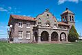
Nevada-California-Oregon Railway Co. General Office Building
Also in Alturas, the Nevada-California-Oregon Railway Co. General Office Building was where the railway company managed all its business. It was added to the list in 1974. This building shows us the business side of running a railroad in the past.
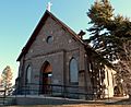
Sacred Heart Catholic Church
The Sacred Heart Catholic Church is a beautiful old church in Alturas. It was built many years ago and became a historic place in 1983. Churches like this are important not just for their religious history, but also for their architecture and how they served the community.
Ancient and Natural Historic Sites
Modoc County is also home to many ancient sites, some of which are "Address Restricted." This means their exact location isn't shared to protect them from damage. These sites often contain clues about the very first people who lived in this area.
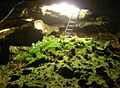
Fern Cave Archeological Site
The Fern Cave Archeological Site is near Tulelake. It was added to the list in 1975. Caves like this can hold amazing secrets about ancient cultures, including tools, art, and other signs of early human life.
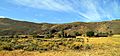
Lava Beds National Monument Archeological District
Lava Beds National Monument is a really cool place with lots of caves and volcanic features. It's also an important archeological district, listed in 1991. This area has many sites where ancient people lived, hunted, and created art. It's like a giant outdoor museum!
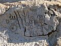
Petroglyph Point Archeological Site
Near Tulelake, Petroglyph Point Archeological Site is famous for its ancient rock carvings. "Petroglyphs" are pictures or symbols carved into rock. This site was listed in 1975 and gives us a direct look at the art and communication of people who lived thousands of years ago.
A National Historic Landmark: Tule Lake Segregation Center
One of the most important sites in Modoc County is the Tule Lake Segregation Center. It's so important that it's a "National Historic Landmark," which is the highest level of historical recognition.
What was Tule Lake Segregation Center?
The Tule Lake Segregation Center was a place where Japanese Americans were held during World War II. After the attack on Pearl Harbor, the U.S. government forced many Japanese Americans to leave their homes and live in these camps. Tule Lake was unique because it became a "segregation center" for those who were seen as "disloyal" or caused problems in other camps. It was listed as a historic place in 2006.
Why is it important to remember Tule Lake?
This site is a powerful reminder of a difficult time in American history. It teaches us about civil rights, government actions during wartime, and the experiences of Japanese Americans. Protecting this site helps make sure we learn from the past and work towards a more fair future.
Images for kids
-
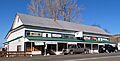
The historic Adin Supply Company building.
-
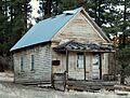
The old Jess Valley Schoolhouse.
-
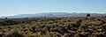
A view from Lava Beds National Monument.
-
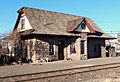
The NCO Railway Depot in Alturas.
-
The General Office Building for the NCO Railway.
-
Ancient petroglyphs at Petroglyph Point.
-
Sacred Heart Catholic Church in Alturas.
-
A view of the Tule Lake Segregation Center.
-
An image related to Fern Cave Archeological Site.


