
National Register of Historic Places listings in North Hempstead (town), New York facts for kids
Welcome to the Town of North Hempstead, New York! This area is full of amazing old buildings and places that are super important to history. These special spots are listed on the National Register of Historic Places. Think of it like a national hall of fame for historical sites!
When a place is on this list, it means it's recognized for its unique history, cool architecture, or for being important to local or national events. Let's explore some of these cool places right here in North Hempstead!
Contents
Historic Homes and Mansions
North Hempstead has many beautiful old homes that tell stories of the past.
The William Barstow Mansion
Located in Kings Point, the William Barstow Mansion is a grand old house from the "Gilded Age." This was a time in American history (late 1800s to early 1900s) when many people became very wealthy and built huge, fancy homes. William Barstow was important because he helped found Kings Point and was a pioneer in electricity! Today, this mansion is part of the American Merchant Marine Museum.
Cedarmere-Clayton Estates: A Poet's Home
In Roslyn Harbor, you'll find the Cedarmere-Clayton Estates. This beautiful property was once the home of William Cullen Bryant, a famous American poet and journalist. Later, it belonged to Childs Frick, who was the son of a very wealthy industrialist. Now, parts of this estate are open to the public as part of the Nassau County Museum of Art. It's a great place to see art and enjoy nature.

The John Philip Sousa House
Did you know that the famous "March King," John Philip Sousa, lived in North Hempstead? His home, located at 14 Hicks Lane in Sands Point, is a very special place. Sousa was a brilliant bandleader and composer, known for his amazing marches like "Stars and Stripes Forever." He lived here from 1915 until he passed away. It's cool to think that such famous music was created in a house right here!

William Landsberg House: Modern Design
In Port Washington, there's a unique home called the William Landsberg House. What makes it special? It was designed by and was the home of New York architect William Landsberg himself! This house shows off his modern design ideas.

Important Public Buildings and Landmarks
Beyond homes, North Hempstead also has historic public buildings and other landmarks.
Execution Rocks Light: A Lighthouse Story
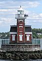
Out in the Long Island Sound, near Port Washington, stands the Execution Rocks Light. This lighthouse has been guiding ships safely for a long time. Lighthouses are super important because they warn boats about dangerous rocks or shallow waters, especially at night or in foggy weather. It's a cool piece of maritime history!

Gould-Guggenheim Estate: A Grand Castle
Also in Port Washington is the amazing Gould-Guggenheim Estate, which includes a building known as Castle Gould. Imagine living in a castle! This estate was once owned by very wealthy and powerful families, the Goulds and the Guggenheims. These families were known for their huge fortunes and their love for grand architecture.

North Hempstead Town Hall
The North Hempstead Town Hall, located in Manhasset, is where a lot of important decisions for the town are made. It's a historic building that has served the community for many years. It's a place where local government works to keep the town running smoothly.

Historic Post Offices
Two post offices in North Hempstead are on the National Register: the Great Neck Post Office and the Mineola Post Office. These buildings are not just places to send mail; they are also examples of important architecture from their time. The Mineola Post Office is especially interesting because it was built during the "New Deal" era, a time when the government created many public works projects to help the country recover from the Great Depression.


Historic Districts and Community Spots
Some areas are special because they have many historic buildings together, forming a "historic district."
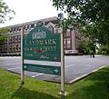
Main Street Historic District (Roslyn)
The Main Street Historic District in Roslyn is like stepping back in time! It has many buildings from the 1700s and 1800s that are still mostly the same as they were long ago. This area shows what Roslyn looked like when it was first growing.

Roslyn Grist Mill: A Piece of Dutch History
Also in Roslyn is the Roslyn Grist Mill. This mill is super rare because it's one of the few remaining commercial buildings built by the early Dutch settlers in the United States! Grist mills were essential long ago for grinding grain into flour. It's a cool reminder of how people lived and worked centuries ago.

Roslyn Village Historic District
Another important area in Roslyn is the Roslyn Village Historic District. This part of town shows what Roslyn looked like in the later 1800s, especially its shops and businesses. It's a great example of how towns developed over time.

Saddle Rock Grist Mill
In Saddle Rock, you can find another historic grist mill. The Saddle Rock Grist Mill is located right by Little Neck Bay. Like the Roslyn Grist Mill, it played a key role in the local economy by processing grains.

Other Notable Places
Old Westbury Gardens: A Beautiful Estate
Old Westbury Gardens in Westbury is a stunning estate with beautiful gardens and a grand mansion. It was once the home of the Phipps family. It's a wonderful place to visit and see amazing plants, flowers, and classic architecture.

United States Merchant Marine Academy
The United States Merchant Marine Academy in Kings Point is a very important place. It's a special school that trains people to become officers in the U.S. merchant marine. These are the brave men and women who operate the ships that carry goods all over the world. The academy has been training future sailors since 1943!

These are just some of the many fascinating historic places in the Town of North Hempstead. Each one has a unique story and helps us understand the rich history of this area!
Images for kids
-
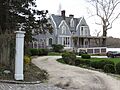
The Clapham-Stern House in Roslyn Harbor.
-
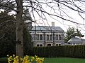
Clifton, a historic home in Roslyn Harbor.
-
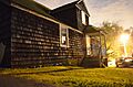
The Thomas Dodge Homestead at night.
-
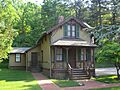
The Eastman Cottage in Roslyn.
-
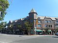
The Grace and Thomaston Buildings in Great Neck Plaza.
-
The Greenridge-Arthur Williams House.
-
The historic Hicks Lumber Company Store.
-
The Mackay Estate Dairyman's Cottage.
-
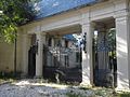
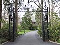
The Mackay Estate Gate Lodge.
-
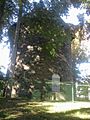
The Mackay Estate Water Tower.
-
The Main Street School in Port Washington.
-
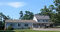
The Manhasset Monthly Meeting of the Society of Friends.
-
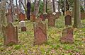
Monfort Cemetery, a historic burial ground.
-
The Mudge Farmhouse in Roslyn Harbor.
-
The Horatio Gates Onderdonk House.
-
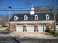
The Rescue Hook & Ladder Company No. 1 Firehouse.
-
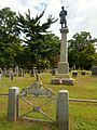
Roslyn Cemetery.
-
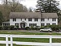
Roslyn House in Roslyn Heights.
-
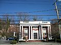
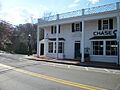
The Roslyn National Bank and Trust Company Building.
-
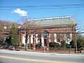
The Roslyn Savings Bank Building.
-
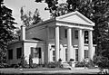
Saint Mary's Chapel in Carle Place.
-
The Almeron and Olive Smith House.
-
The Stephen and Charles Smith House.
-
Springbank in Roslyn Harbor.
-
The Stepping Stones Light Station.
-
The Willet Titus House.
-
The Toll Gate House in Greenvale.
-
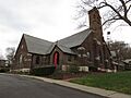
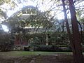
Trinity Church Complex in Roslyn.
-
The Samuel Adams Warner House.
-
Willowmere in Roslyn Harbor.


.jpg)


-1.JPG)


