
National Register of Historic Places listings in Oahu facts for kids

Oahu is a super important island in Hawaii! It's the most populated island and home to the big city of Honolulu. This article is all about the amazing places on Oahu that are listed on the National Register of Historic Places. Think of this register as a special list of buildings, areas, and sites that are really important to history and should be protected. Oahu has 167 of these special places, and 16 of them are even more important, called National Historic Landmarks! Sadly, a few places that were once on the list have been taken off because they were torn down.
Contents
Cool Historic Places on Oahu
There are so many cool and important places on Oahu! Here are some of the most interesting ones that are listed as historic:
Famous Buildings and Landmarks
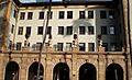
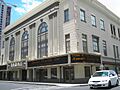
- Alexander and Baldwin Building: This building in Honolulu was listed in 1979. It's a cool old building that tells a story about Hawaii's past.
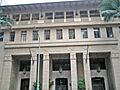
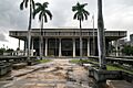
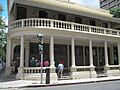
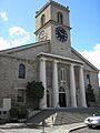
- Aliiolani Hale: This beautiful building on King Street in Honolulu was listed in 1972. It's a very important government building in Hawaii's history.
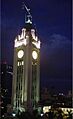
- Aloha Tower: Standing tall at Pier 9 in Honolulu Harbor, the Aloha Tower was listed in 1976. It used to be the tallest building in Hawaii and welcomed many ships to the island!
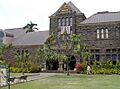
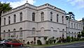
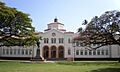
- Bernice P. Bishop Museum: Located on Kalihi Street in Honolulu, this museum was listed in 1982. It's a fantastic place to learn about Hawaiian and Pacific island culture and history.
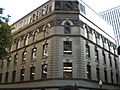
- C. Brewer Building: Another historic building in Honolulu, listed in 1980.
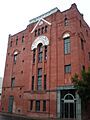
- Dillingham Transportation Building: This building on Bishop Street in Honolulu was listed in 1979. It played a role in transportation history.
- Hawaii Theatre: Found on Bethel Street in Honolulu, this theatre was listed in 1978. It's a beautiful old theater where many shows and movies have been enjoyed.
- Honolulu Museum of Art: This museum on S. Beretania Street in Honolulu was listed in 1972. It's a great spot to see amazing art from all over the world.
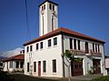
- Kamehameha V Post Office: This historic post office at the corner of Merchant and Bethel Streets in Honolulu was listed in 1972. It's a reminder of how mail used to be delivered.
- Moana Hotel: Located on Kalakaua Avenue in Honolulu, the Moana Hotel was listed in 1972. It's one of the oldest and most famous hotels in Waikiki!
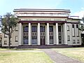
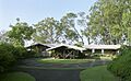
- President William McKinley High School: This school in Honolulu was listed in 1980. It's an important part of the island's educational history.
- Royal Brewery: This old brewery on S. Queen Street in Honolulu was listed in 1972. It shows a different side of Honolulu's past.
- U.S. Immigration Office: This building on Ala Moana Boulevard in Honolulu was listed in 1973. It was once the place where people arriving in Hawaii would go.
- U.S. Post Office, Customhouse, and Courthouse: This important building on Merchant Street in Honolulu was listed in 1975. It served many different government purposes.
Military and Defense Sites
Oahu has many historic sites related to its military past, especially from World War II.
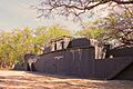
- Battery Hasbrouck, Hawkins, Hawkins Annex, Jackson, and Selfridge: These are old coastal artillery sites at Fort Kamehameha in Honolulu, all listed in 1984. They were built to protect the island.
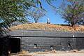
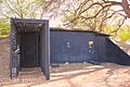
- Battery Randolph: This coastal artillery site in Fort DeRussy Military Reservation in Honolulu was listed in 1984 and is now a museum!
- Commander in Chief Pacific Fleet Headquarters (World War II): This important building at Pearl Harbor Naval Base was listed as a National Historic Landmark in 1987. It was a key place during World War II.
- Hickam Air Force Base: Located southeast of Pearl Harbor Naval Base in Honolulu, Hickam Field was listed as a National Historic Landmark in 1985. It played a big role in the war.
- Kaneohe Naval Air Station: This naval air station in Kailua was listed as a National Historic Landmark in 1987.
- Opana Radar Site: This site near Kawela Bay was listed as a National Historic Landmark in 1991. It was an important radar station during World War II.
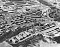
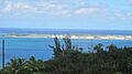
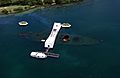
- Pearl Harbor, U.S. Naval Base: This huge naval base near Pearl City was listed as a National Historic Landmark in 1966. It's famous for the attack that brought the U.S. into World War II.
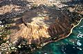
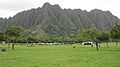
- Fort Ruger Historic District: This area on Diamond Head Road in Honolulu was listed in 1983. It was a military fort built into the famous Diamond Head crater.
- Palm Circle Historic District (Fort Shafter): This area in Honolulu was listed as a National Historic Landmark in 1984. It's part of Fort Shafter, an important army base.
- Schofield Barracks Historic District: This military base in Schofield Barracks was listed in 1998. It's a large army post.
- Schofield Barracks Stockade: Also at Schofield Barracks, this stockade was listed in 1998.
- Wheeler Field: This army airfield in Schofield Barracks was listed as a National Historic Landmark in 1987. It was attacked during Pearl Harbor.
Historic Ships
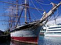
- FALLS OF CLYDE: This amazing ship at Pier 7 in Honolulu Harbor was listed as a National Historic Landmark in 1973. It's the only surviving iron-hulled, four-masted, full-rigged ship in the world, and the only sail-driven oil tanker!
- U.S.S. ARIZONA Memorial: This memorial near Pearl City was listed in 1966. It honors the sailors who lost their lives on the USS Arizona during the attack on Pearl Harbor.
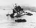
- USS ARIZONA Wreck: The actual wreck of the USS Arizona in Pearl Harbor was listed as a National Historic Landmark in 1989. It's a powerful reminder of history.
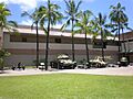
- USS BOWFIN: This submarine in Honolulu was listed as a National Historic Landmark in 1982. You can visit it as a museum!
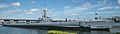
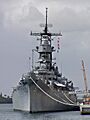
- U.S.S. MISSOURI: This famous battleship in Honolulu was listed in 1971. It's where World War II officially ended, and now it's a museum ship!
- USS UTAH Wreck: The wreck of the USS Utah in Pearl Harbor was listed as a National Historic Landmark in 1989. It's another ship that was sunk during the attack on Pearl Harbor.
Important Cultural and Natural Sites
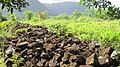
- Bellows Field Archeological Area: This area in Waimanalo was listed in 1973 and holds important archaeological finds.
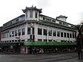
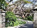
- Chinatown Historic District: This lively area in Honolulu was listed in 1973. It's full of unique shops, restaurants, and historic buildings.
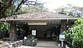
- Foster Botanical Garden: This beautiful garden in Honolulu was listed in 1993. It's a peaceful place with many different plants.
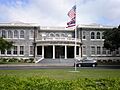
- Hawaii Capital Historic District: This area in Honolulu was listed in 1978 and includes important government buildings like the State Capitol.
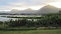
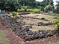
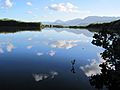
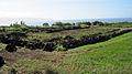
- Heeia Fishpond: This ancient fishpond in Kaneohe was listed in 1973. Hawaiian fishponds are amazing examples of ancient engineering.
- Honouliuli Internment Camp: This site near Waipahu was listed in 2012. It was a camp during World War II.
- Huilua Fishpond: Located in Kahana Bay near Kaneohe, this fishpond was listed as a National Historic Landmark in 1966. It's another incredible example of Hawaiian aquaculture.
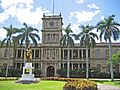
- ʻIolani Palace: This stunning palace in Honolulu was listed as a National Historic Landmark in 1966. It's the only official residence of royalty in the United States!
- Kahaluu Fish Pond: This fishpond in Kahaluu was listed in 1973.
- Kahaluu Taro Lo'i: These ancient taro patches in Kahaluu were listed in 1973. Taro was a very important food for Hawaiians.
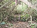
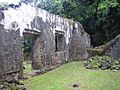
- Kaniakapupu: These are the ruins of King Kamehameha III's summer palace in Nuuanu, listed in 1986.
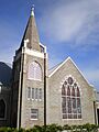
- Kaumakapili Church: This church in Honolulu was listed in 2008.
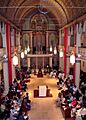
- Kawaiahao Church and Mission Houses: These important religious sites in Honolulu were listed as a National Historic Landmark in 1966. Kawaiahao Church is known as the "Westminster Abbey of Hawaii."
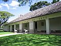
- Keaiwa Heiau: This ancient temple site in Aiea was listed in 1972. It was a place where people used plants for healing.
- Kualoa Ahupua'a Historical District: This large historical area near Kaneohe was listed in 1974. An ahupua'a is a traditional Hawaiian land division.
- Kukaniloko Birth Site: This sacred birth site near Wahiawa was listed in 1973. It was a special place where Hawaiian chiefs were born.
- Kupopolo Heiau: This ancient temple site near Haleiwa was listed in 1973.
- Kyoto Gardens of Honolulu Memorial Park: These gardens in Honolulu were listed in 2004. They offer a peaceful, beautiful space.
- Molii Fishpond: Another historic fishpond near Kaneohe, listed in 1972.
- National Memorial Cemetery of the Pacific: This cemetery in Honolulu was listed in 1976. It's a beautiful and respectful place to honor those who served.
- Nuuanu Petroglyph Complex: This site in Honolulu was listed in 1973 and features ancient rock carvings.
- Okiokilepe Pond: This pond near Pearl Harbor was listed in 1973.
- Pahukini Heiau: This ancient temple site in Kailua was listed in 1972.
- Puu o Mahuka Heiau: This very important temple site near Haleiwa was listed as a National Historic Landmark in 1966. It overlooks Waimea Bay.
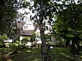
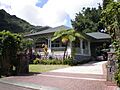
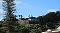
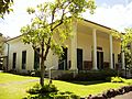
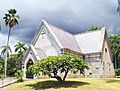
- Queen Emma's Summer Home (Hanaiakamalama): This historic home in Honolulu was listed in 1972. It was the summer retreat for Queen Emma.
- Royal Mausoleum: This burial site for the Hawaiian royal family in Honolulu was listed in 1972. It's a very important place for Hawaiian history.
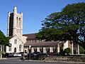
- St. Andrew's Cathedral: This beautiful cathedral in Honolulu was listed in 1973.
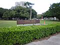
- Thomas Square: This park in Honolulu was listed in 1972. It's a historic public space.
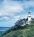
- U.S. Coast Guard Diamond Head Lighthouse: This lighthouse in Honolulu was listed in 1980. Lighthouses are important for guiding ships safely.
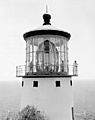
- U.S. Coast Guard Makapuu Point Light: This lighthouse near Waimanalo was listed in 1977.
- Ulu Po Heiau: This ancient temple site in Kailua was listed in 1972.
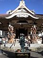
- Wakamiya Inari Shrine: This shrine in Waipahu was listed in 1980. It's a place of worship.
- War Memorial Natatorium: This swimming pool memorial on Kalakaua Avenue in Honolulu was listed in 1980. It honors those who served in World War I.
- Washington Place: This historic home in Honolulu was listed as a National Historic Landmark in 1973. It was once the home of Queen Liliʻuokalani and later served as the governor's mansion.
Historic Homes and Estates
Many beautiful and important homes on Oahu are also listed as historic places. These homes often show different styles of architecture and belonged to important people in Hawaii's past.
- Mr. and Mrs. David Barry Jr. House: This home in Honolulu was listed in 2017.
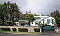
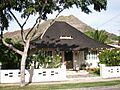
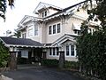
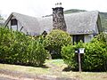
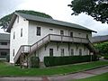
- Boettcher Estate: This estate in Kailua was built in 1937 and designed by famous architect Vladimir Ossipoff. It was listed in 2002.
- Thomas Alexander Burningham House: This house in Honolulu was listed in 1993.
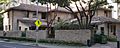
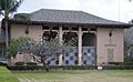
- Georges de S. Canavarro House: This house in Honolulu was listed in 1980 and is now a Korean Cultural Center.
- Lloyd Case House: This house in Honolulu was listed in 1987.
- Jean Charlot House: This home in Honolulu was listed in 2000.
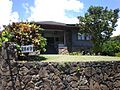
- James L. Coke House: Also called Waipuna, this house in Honolulu was built in 1934 and listed in 1986.
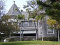
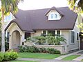
- Grace Cooke House: This bungalow-style home in Honolulu was built in 1912 and listed in 1983.
- Charles Montague Cooke, Jr., House and Kuka'O'O Heiau: This grand home in Honolulu was built in 1912 and listed in 1985. It also includes an ancient Hawaiian temple.
- Clarence H. Cooke House: This house in Honolulu was listed in 1986.
- Bartlett Cooper House: This home in Honolulu was listed in 1987.
- C.W. Dickey House: This house in Honolulu was listed in 1984. C.W. Dickey was a well-known architect in Hawaii.
- Dilks Property: This property in Kailua was listed in 2016.
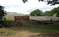
- James D. Dole Homestead: This 1901 house of a famous pineapple planter in Waipahu was listed in 1978.
- Carl H. Duhrsen House: This home in Honolulu was listed in 1987.
- Jessie Eyman–Wilma Judson House: This house in Honolulu was built in 1926 by architect C.W. Dickey and listed in 1986.
- Dr. Robert Faus House: This home in Honolulu was listed in 1987.
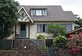
- J. B. Guard House: This house in Honolulu was listed in 2015.
- John Guild House: This home in Honolulu was listed in 1980.
- Edgar and Lucy Henriques House: This house in Honolulu was listed in 1984.
- Alfred Hocking House: This home in Honolulu was built in 1903 and listed in 1984. It was designed in the Queen Anne style.
- Lemon Wond Holt House: This house in Honolulu was listed in 2006.
- Houses at 3023, 3023A, 3023B, 3027, 3033, 3033B Kalakaua Avenue: These homes in Honolulu were all built in 1932 and listed in 1987.
- House at 4109 Black Point Road: This home in Honolulu was listed in 1987.
- John and Kate Kelly House: This house in Honolulu was listed in 1991.
- Lihiwai: This property in Honolulu was listed in 1982.
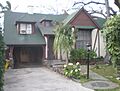
- Liljestrand House: This house in Honolulu was built in 1952 by architect Vladimir Ossipoff and listed in 2008. It was even featured in a magazine!
- R.N. Linn House: This home in Honolulu was listed in 1986.
- J.P. Mendonca House: This home in Honolulu was listed in 1986.
- George D. Oakley House: This Tudor cottage in Honolulu was listed in 1984.
- Frederick Ohrt House: This home in Honolulu was listed in 1987.
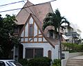
- J. Alvin Shadinger House: Also known as The Gingerbread House, this home in Honolulu was listed in 1987.
- Charles A. Simpson House: This home in Honolulu was listed in 1987.
- Dr. Archibald Neil Sinclair House: This Colonial Revival style house in Honolulu was built in 1917 and listed in 1983.
- Frank Tavares House: This home in Honolulu was listed in 1987.
- Ernest Shelton Van Tassel House: Also called Nutridge, this home in Honolulu was built in 1922 and listed in 1981. It was once a macadamia nut plantation.
- H. Alexander Walker Residence: This home in Honolulu was listed in 1973.
- George R. Ward House: This home in Honolulu was listed in 2016.
Other Historic Sites
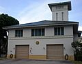
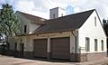
- Central Fire Station: This fire station in Honolulu was renovated in 1934 and listed in 1980.
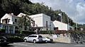
- Central Intermediate School: This school in Honolulu was listed in 2004.
- Church of the Crossroads: This church in Honolulu was listed in 1992.
- Friendship Garden: This garden in Kaneohe was listed in 2016.
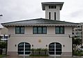
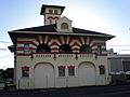
- Kaimuki Fire Station: This fire station in Honolulu was built in 1924 and listed in 1980.
- Kakaako Fire Station: This fire station in Honolulu was built in 1929 and listed in 1980.
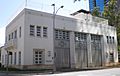
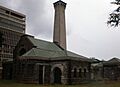
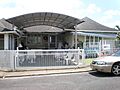
- Kakaako Pumping Station: This pumping station in Honolulu was listed in 1978.
- Kalihi Fire Station: This fire station in Honolulu was built in 1924 and listed in 1980.
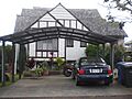
- Kaneohe Ranch Building: This building in Kailua was listed in 1987.
- Kapuaiwa Building: This building in Honolulu was built in 1884 and listed in 1973.
- Kunia Camp: This area in Kunia was listed in 2014.
- Leleahina Heiau: This ancient temple site in Kaneohe was listed in 1973.
- Linekona School: This school in Honolulu was listed in 1980.
- Makiki Fire Station: This fire station in Honolulu was built in 1929 and listed in 1980.
- MALIA (Hawaiian canoe): This wooden dugout canoe in Honolulu was built in 1933 and listed in 1993.
- Marconi Wireless Telegraphy Station: This station in Kahuku was listed in 2013. It was important for early radio communication.
- Marigold Building: This building in Waipahu was listed in 1983.
- Merchant Street Historic District: This area in Honolulu was listed in 1973. It's a historic business district.
- Moiliʻili Japanese Cemetery: This cemetery in Honolulu was listed in 2015.
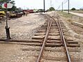
- Oahu Railway and Land Company Right-of-Way: This historic railway line near Nanakuli was listed in 1975.
- Palama Fire Station: This fire station in Honolulu was built in 1901 and listed in 1976.
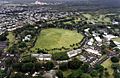
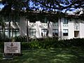
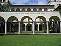
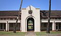
- Punahou School Campus: This school campus in Honolulu was listed in 1972.
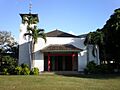
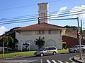
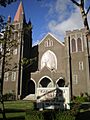
- Sacred Heart Church: This church in Honolulu was listed in 2001.
- Salvation Army Waioli Tea Room: This building in Honolulu was built in 1926 and listed in 1998. It started as a girls' home and bakery.
- Small Heiau: This ancient temple site near Kaaawa was listed in 1973.
- Mabel Smyth Memorial Building: This building in Honolulu was built in 1941 and listed in 1994.
- Tantalus-Round Top Road: This scenic road in Honolulu was listed in 2009.
- Waialua Agricultural Company Engine No. 6: This old train engine near Lualualei was listed in 1974 and is now at the Hawaiian Railway Society.
- Waialua Fire Station: This fire station in Haleiwa was built in 1932 and listed in 1980.
- Waialua School: This school in Haleiwa was listed in 1980.
Places No Longer on the List
Sometimes, historic places are removed from the National Register, usually because they were torn down or destroyed. Here are a few places on Oahu that used to be on the list:
- Aiea Sugar Mill: This sugar mill in Aiea was listed in 1996 but was torn down in 1998 and removed from the list in 2009.
- Katsuki House: This house in Honolulu was listed in 1976 but was destroyed by fire in 1978.
- Lishman Building: This building in Honolulu was listed in 1978 but was torn down and removed from the list in 2012.
- Alexander Young Building: This building in Honolulu was listed in 1980 but was torn down in 1981 and removed from the list in 2009.
Images for kids
-
The Alexander and Baldwin Building.
-
Aliiolani Hale, a historic government building.
-
Aloha Tower at night.
-
Battery Hasbrouck, an old coastal artillery site.
-
Battery Hawkins.
-
Battery Hawkins Annex.
-
Battery Randolph, now a museum.
-
The front of the Bernice P. Bishop Museum.
-
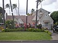
The Boettcher Estate in Kailua.
-
The C. Brewer Building.
-
The Thomas Alexander Burningham House.
-
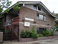
The Georges de S. Canavarro House.
-
The Lloyd Case House.
-
The Central Fire Station.
-
Central Intermediate School.
-
The Jean Charlot House.
-
A building in the Chinatown Historic District.
-
The Church of the Crossroads.
-
CINCPAC Headquarters at Pearl Harbor.
-
The James L. Coke House.
-
The Grace Cooke House.
-
The Charles Montague Cooke, Jr., House.
-
The Clarence H. Cooke House.
-
The Bartlett Cooper House.
-
The C.W. Dickey House.
-
The Dillingham Transportation Building.
-
The James D. Dole Homestead.
-
The Carl H. Duhrsen House.
-
The Jessie Eyman–Wilma Judson House.
-
The FALLS OF CLYDE ship.
-
The Dr. Robert Faus House.
-
Diamond Head, part of the Fort Ruger Historic District.
-
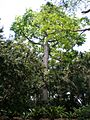
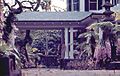
A giant kapok tree in Foster Botanical Garden.
-
The John Guild House.
-
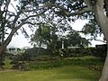
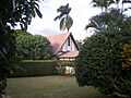
Hawaii's Capitol building, part of the Hawaii Capital Historic District.
-
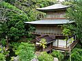
The Hawaii Shingon Mission.
-
The Hawaii Theatre.
-
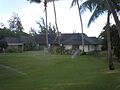
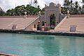
Heeia Fishpond.
-
The Edgar and Lucy Henriques House.
-
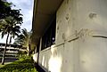
Bullet holes at Hickam Air Force Base headquarters.
-
The Alfred Hocking House.
-
The Lemon Wond Holt House.
-
The Honolulu Museum of Art.
-
House at 3023 Kalakaua Avenue.
-
House at 3023A Kalakaua Avenue.
-
House at 3023B Kalakaua Avenue.
-
House at 3027 Kalakaua Avenue.
-
House at 3033 Kalakaua Avenue.
-
House at 3033B Kalakaua Avenue.
-
Huilua Fishpond.
-
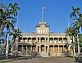
Iolani Palace.
-
Kahaluu Fish Pond.
-
Kahaluu Taro Lo'i.
-
Kaimuki Fire Station.
-
Kakaako Fire Station.
-
Kakaako Pumping Station.
-
Kalihi Fire Station.
-
Kamehameha V Post Office.
-
Kaneohe Naval Air Station.
-
Kaneohe Ranch Building.
-
The ruins of Kaniakapupu.
-
The Kapuaiwa Building.
-
Kaumakapili Church.
-
Kawaewae Heiau.
-
Kawaiahao Church.
-
Kawailoa Ryusenji Temple (now relocated).
-
Keaiwa Heiau.
-
Kualoa Ahupua'a Historical District.
-
Kukaniloko Birth Site.
-
Pahukini Heiau.
-
Kyoto Gardens of Honolulu Memorial Park.
-
Lihiwai.
-
The Liljestrand House.
-
Linekona School.
-
The R.N. Linn House.
-
Makiki Fire Station.
-
The Marigold Building.
-
McKinley High School.
-
The J.P. Mendonca House.
-
A building in the Merchant Street Historic District.
-
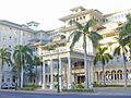
The Moana Hotel.
-
A gravesite at Moiliʻili Japanese Cemetery.
-
Molii Fishpond.
-
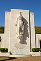
Lady Columbia at the National Memorial Cemetery of the Pacific.
-
Oahu Railway and Land Company Right-of-Way.
-
The George D. Oakley House.
-
The Frederick Ohrt House.
-
Okiokilepe Pond.
-
The Cathedral of Our Lady of Peace.
-
Palama Fire Station.
-
Palm Circle Historic District.
-
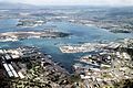
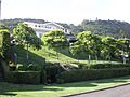
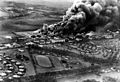
An aerial view of Pearl Harbor.
-
The Joseph W. Podmore Building.
-
Old School Hall at Punahou School.
-
Puu o Mahuka Heiau.
-
Queen Emma's Summer Home.
-
The Royal Brewery.
-
The Chapel at the Royal Mausoleum.
-
Sacred Heart Church.
-
The Salvation Army Waioli Tea Room.
-
The J. Alvin Shadinger House.
-
The Charles A. Simpson House.
-
The Dr. Archibald Neil Sinclair House.
-
The Mabel Smyth Memorial Building.
-
St. Andrew's Cathedral.
-
Tantalus-Round Top Road.
-
The Frank Tavares House.
-
Thomas Square.
-
The U.S. Coast Guard Diamond Head Lighthouse.
-
The U.S. Coast Guard Makapuu Point Light.
-
The U.S. Immigration Office.
-
The U.S. Post Office, Customhouse, and Courthouse.
-
Ulu Po Heiau.
-
An aerial view of the U.S.S. ARIZONA Memorial.
-
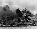
The USS ARIZONA Wreck during the attack on Pearl Harbor.
-
The USS BOWFIN submarine.
-
The U.S.S. MISSOURI battleship.
-
The USS UTAH Wreck during the attack on Pearl Harbor.
-
Waialua Fire Station.
-
Waialua School.
-
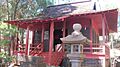
The Wakamiya Inari Shrine.
-
The H. Alexander Walker Residence.
-
The War Memorial Natatorium.
-
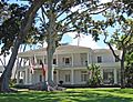
Washington Place.
-
Wheeler Field on December 7, 1941.


.jpg)


.JPG)


.jpg)


,_Honolulu,_Hawaii.JPG)


.jpg)
_burning_after_the_Japanese_attack_on_Pearl_Harbor_-_NARA_195617_-_Edit.jpg)

_capsizing_at_Pearl_Harbor_on_7_December_1941_(80-G-266626).jpg)


.jpg)
