
National Register of Historic Places listings in Placer County, California facts for kids
This is a list of amazing historic places in Placer County, California. These special spots are listed on the National Register of Historic Places, which means they are important parts of American history and culture. Think of it like a Hall of Fame for buildings, sites, and districts!
There are 34 different places in Placer County that have earned a spot on this important list. Each one tells a unique story about the past, from old schools and fire stations to historic homes and natural landmarks. Let's explore some of these cool places!

Historic Buildings in Auburn
Auburn is home to many historic buildings that tell tales of its past.
Old City Buildings and Firehouses
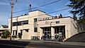
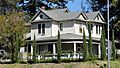
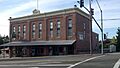
- Auburn City Hall and Fire House: This building at 1103 High Street was once the main place for city government and where firefighters kept their equipment. It was added to the list in 2011.
- Auburn Fire House No. 1: Located at El Dorado Street and Lincoln Way, this was one of the first fire stations in Auburn. It became historic in 2011.
- Auburn Fire House No. 2: You can find this old firehouse at the corner of Washington, Main, and Commercial Streets. It joined the list in 2011.
- Auburn Grammar School: This school building at 1225 Lincoln Way taught many generations of students. It was recognized as historic in 2012.
- Auburn Masonic Temple: At 948 Lincoln Way, this temple is a meeting place for the Masons, a fraternal organization with a long history. It was listed in 2011.
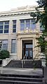
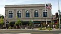
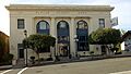
- Auburn Public Library: The library at 175 Almond Street has been a center for learning and reading for many years. It became historic in 2011.
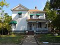
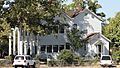
- Irene Burns House: This historic home at 405 Linden Avenue was added to the list in 2013.
- Oddfellows Hall: Located at 1256 Lincoln Way, this three-story red brick building is an example of Italianate architecture. It was built by Henry T. Holmes, one of Auburn's founding fathers, and has been home to the IOOF Lodge No. 7 since 1852. It was listed in 2011.
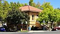
- Placer County Bank: This old bank building at 874 Lincoln Way was an important financial center in Auburn. It joined the list in 2011.
Other Important Auburn Sites
- DeWitt General Hospital: Found at 1st Street and Bell Avenue, this hospital played a big role in the community's health. It was listed in 2016.
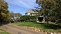
- El Toyon: This historic property at 211 Brook Road became a listed site in 2010.
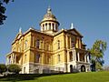
- Old Auburn Historic District: This whole area, roughly bounded by Maple, Commercial, Court, Washington, Spring, and Sacramento Streets, is recognized for its historic importance. It was listed way back in 1970!
Historic Places in Other Placer County Cities
Placer County has many other towns with their own unique historic treasures.
Rocklin's Industrial Past
- California Granite Company: At 5255 Pacific Street in Rocklin, this site shows the history of granite quarrying in the area. It was listed in 2012.
Roseville's Community Hubs
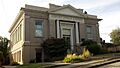
- Carnegie Library: This beautiful old library at 557 Lincoln Street in Roseville was built with money from Andrew Carnegie, who funded many libraries across the country. It was listed in 2009.
- Fiddyment Ranch Main Complex: Located at 4440 Phillip Road in Roseville, this ranch complex tells the story of local agriculture. It became historic in 2010.
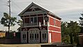
- Haman House: This historic home at 424 Oak Street in Roseville was listed in 1976.
- Maidu Museum & Historic Site: At 1970 Johnson Ranch Drive in Roseville, this site, also known as the Strap Ravine Nisenan Maidu Indian Site, preserves the history of the Nisenan Maidu people. It was listed in 1973.
Colfax's Railroad Legacy
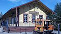
- Colfax Freight Depot: This old train station at 7 Main Street in Colfax was important for moving goods by rail. It was listed in 1999.
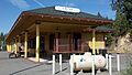
- Colfax Passenger Depot: Located at Main Street and Railroad Avenue, this station served train passengers. It became historic in 1999.
- Stevens Trail: This historic trail, roughly bounded by Iowa Hill, the canyon of the North Fork of the American River, and the ridge of Colfax, was listed in 2002.
Penryn's Quarry History
- Griffith House: This historic home at 7325 English Colony Way in Penryn was listed in 1978.
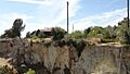
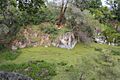
- Griffith Quarry: Found on Taylor Road in Penryn, this quarry was a significant site for stone extraction. It was listed in 1977.
Lincoln's Community Buildings
- Lincoln Public Library: This library at 590 Fifth Street in Lincoln has served the community for many years. It was listed in 1990.
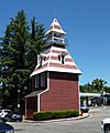
- Woman's Club of Lincoln: Located at 499 E Street, this club has been an important part of community life for women in Lincoln. It was listed in 2001.
Tahoe City's Lakeside Landmarks
- Chapel of the Transfiguration: This beautiful chapel at 855 W. Lake Boulevard in Tahoe City was listed in 2011.
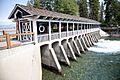
- Lake Tahoe Dam: This dam on SR 89 at the Truckee River in Tahoe City helps control the water level of Lake Tahoe. It was listed in 1981.
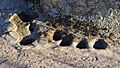
- Outlet Gates and Gatekeeper's Cabin: Found on U.S. 89 at the mouth of the Truckee River in Tahoe City, these structures are important for managing the lake's water flow. They were listed in 1972.
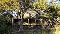
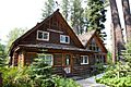
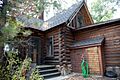
- Watson Log Cabin: This historic log cabin at 560 N. Lake Boulevard in Tahoe City gives us a peek into early life by the lake. It was listed in 1979.
Other Notable Placer County Sites
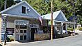
- Dutch Flat Historic District: This entire district, including Main and Stockton Streets in Dutch Flat, is recognized for its historic charm. It was listed in 1973.
- Michigan Bluff-Last Chance Trail: This trail, stretching from Michigan Bluff northeast to Last Chance, is a historic pathway. It was listed in 1992.
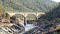
- Mountain Quarries Bridge: This impressive bridge over the North Fork of the American River near Auburn was listed in 2004.
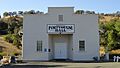
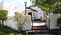
- Newcastle Portuguese Hall: Located on Taylor Road in Newcastle, this hall has been a gathering place for the Portuguese community. It was listed in 1982.
- Summit Soda Springs: Southeast of Soda Springs, this natural spring area was a popular retreat in the past. It was listed in 1978.
These historic places help us remember and learn about the people and events that shaped Placer County and California!
Images for kids
-
Auburn City Hall and Fire House
-
Auburn Fire House No. 1
-
Auburn Fire House No. 2
-
Auburn Grammar School
-
Auburn Masonic Temple
-
Auburn Public Library
-
Irene Burns House
-
California Granite Company
-

Carnegie Library (Roseville)
-
Colfax Freight Depot
-
Colfax Passenger Depot
-
Dutch Flat Historic District
-
El Toyon
-
Fiddyment Ranch Main Complex
-
Griffith House
-
Griffith Quarry
-
Haman House
-
Lake Tahoe Dam
-
Lincoln Public Library
-
Mountain Quarries Bridge
-
Newcastle Portuguese Hall
-
Oddfellows Hall
-
Old Auburn Historic District
-
Outlet Gates and Gatekeeper's Cabin
-
Placer County Bank
-
Maidu Museum & Historic Site
-
Watson Log Cabin
-
Woman's Club of Lincoln


,_main_building.jpg)
,_facade.jpg)

.jpg)

_Public_Library.jpg)

_Portuguese_Hall,_facade.jpg)


,_entrance.jpg)
