
National Register of Historic Places listings in Tillamook County, Oregon facts for kids
The National Register of Historic Places is a special list of places in the United States that are important to history. These places could be buildings, archaeological sites, or other landmarks. They are recognized because they tell us about the past and help us understand how people lived long ago. In Tillamook County, Oregon, there are many such places, from ancient sites where early people lived to historic buildings and structures. Protecting these places helps us learn about the rich history of the area.
Contents
Ancient Discoveries: Archaeological Sites
Many of the important historical places in Tillamook County are archaeological sites. These are places where scientists called archaeologists dig up clues about how people lived many, many years ago. They might find old tools, pottery, or even the remains of ancient villages. Because these sites are so fragile and important, their exact locations are often kept secret to protect them.
Cronin Point Site
One interesting archaeological site is called the Cronin Point Site (35-TI-4). It's near Manzanita, Oregon. Scientists believe people lived here between the years 1600 and 1800. They found lots of burned rocks, which might mean it was once a busy village. What's really cool is that they also found pieces of Asian pottery! This suggests that people living here might have traded with or found items from early European ships, like the famous Beeswax wreck. Sadly, it looks like the village was suddenly abandoned, possibly because of an earthquake that changed the land.
Smuggler Cove Shell Midden
Another fascinating site is the Smuggler Cove Shell Midden (35-TI-46), located near Neahkahnie Beach, Oregon. A midden is like an ancient trash pile, but it's full of clues! This midden has shells from mussels, barnacles, and chitons. Scientists used a method called radiocarbon dating to figure out that these shells are from around the year 1660. Around the same time, there might have been a European ship that wrecked nearby. This site is special because it could show us what life was like for local people both before and after they first met Europeans.
Historic Buildings and Structures
Beyond ancient sites, Tillamook County also has many important buildings and structures that tell stories from more recent history.
Cape Meares Lighthouse

The Cape Meares Lighthouse is a landmark located about 5 miles south of the entrance to Tillamook Bay. Lighthouses are like giant flashlights that help guide ships safely along the coast, especially at night or in foggy weather. This lighthouse has been helping sailors for many years and is a beautiful part of Oregon's coastline.
Historic Cottages in Neahkahnie Beach
Near Neahkahnie Beach, Oregon, there are two historic cottages: the A. E. Doyle Cottage and the Mary Frances Isom Cottage. These homes were built a long time ago and show us the style of houses that were popular in the early 1900s. They are preserved because they are good examples of the architecture from that time.
U.S. Coast Guard Station – Tillamook Bay

The U.S. Coast Guard Station – Tillamook Bay is located in Garibaldi, Oregon. The Coast Guard is a branch of the military that protects our coasts and helps people in trouble at sea. This station has been an important part of keeping the waters around Tillamook Bay safe for many years.

Just southeast of Tillamook, Oregon, you'll find the massive U.S. Naval Air Station Dirigible Hangar B. This huge building was once used to house dirigibles, which are like giant blimps or airships. It was originally built with another hangar, Hangar A, but Hangar A sadly burned down in 1992. Hangar B is an amazing example of engineering and a reminder of a time when these large airships were part of naval operations.
Harry F. Wentz Studio

The Harry F. Wentz Studio is north of Manzanita, off U.S. Highway 101. It was designed in 1916 by artist Harry F. Wentz and architect A. E. Doyle. This building is special because it became a model for what is known as the Northwest Regional style of architecture. This style uses colors and materials that fit in with the Pacific Northwest landscape. It often features simple shapes, porches with thin wooden supports, and is built to blend in with nature.
Wilson River Bridge No. 01499

The Wilson River Bridge No. 01499 is an important bridge located on U.S. Highway 101 near Tillamook, Oregon. Bridges are vital for connecting communities and allowing people and goods to travel easily. This bridge is recognized for its historical significance in the transportation network of the area.
Images for kids
-

The A. E. Doyle Cottage.
-

The Mary Frances Isom Cottage.
-
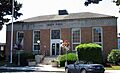
The U.S. Post Office in Tillamook, which is now the City Hall.


See also
- National Register of Historic Places listings in Oregon
- Listings in neighboring counties: Clatsop, Lincoln, Polk, Washington, Yamhill
- Historic preservation
- History of Oregon
- Lists of Oregon-related topics
External links
- Oregon Parks and Recreation Department, National Register Program
- National Park Service, National Register of Historic Places site
