
National Register of Historic Places listings in Clatsop County, Oregon facts for kids
Clatsop County, Oregon, is home to many amazing places listed on the National Register of Historic Places. These special spots are recognized for their history, architecture, or importance to the local community. They help us learn about the past and understand how people lived long ago. From old forts to grand houses and even a historic lightship, these places tell unique stories about Oregon's rich heritage.
Contents
- Historic Buildings and Landmarks in Astoria
- Astor Building: A Symbol of Rebirth
- John Jacob Astor Hotel: From Hotel to Homes
- Astoria City Hall: A Glimpse of Government
- Astoria Column: A Tower with a View
- Astoria Downtown Historic District: A Walk Through Time
- Astoria Elks Building: A Community Hub
- Astoria Fire House No. 2: Protecting the City
- Astoria Marine Construction Company: Building Ships
- Astoria Victory Monument: Honoring Heroes
- Astoria Wharf and Warehouse Company: River Trade
- Robert Rensselaer Bartlett House: A Historic Home
- Peter L. Cherry House: Another Old Astoria Home
- Clatsop County Courthouse: Local Justice
- Old Clatsop County Jail: A Look at the Past
- Erickson–Larsen Ensemble: Two Old Buildings
- Albert W. Ferguson House: A Historic Residence
- Ferdinand Fisher House: An Old Astoria Home
- Capt. George Flavel House: A Museum and Movie Star
- Captain George Conrad Flavel House: Another Flavel Home
- George C. and Winona Flavel House: An 1879 Home
- Martin Foard House: A Piece of Astoria's Past
- Fort Astoria: A Fur Trading Post
- Rev. William S. Gilbert House: A Historic Residence
- Grace Episcopal Church and Rectory: A Place of Worship
- Old Grace Episcopal Church Rectory: An Earlier Home
- Capt. J. H. D. Gray House: A Captain's Home
- John N. Griffin House: An Old Astoria Home
- John Hobson House: A Historic Building
- Gustavus Holmes House: A Glimpse into the Past
- Peter and Maria Larson House: An Early Home
- Christian Leinenweber House: A Historic Residence
- Lightship WAL-604, COLUMBIA: A Floating Lighthouse
- Noonan–Norblad House: A Historic Home
- Judge C. H. Page House: A Judge's Residence
- Shively–McClure Historic District: A Neighborhood's History
- Norris Staples House: An Old Astoria Home
- Charles Stevens House: A Historic Residence
- Svenson Blacksmith Shop: A Place of Craftsmanship
- Union Fishermen's Cooperative Packing Company Alderbrook Station: Fishing History
- Uniontown–Alameda Historic District: A Historic Neighborhood
- U.S. Post Office and Custom House: Mail and Trade
- Warren Investment Company Housing Group: Early Housing
- Andrew Young House and Benjamin Young House: Family Homes
- Historic Sites Beyond Astoria
- Fort Clatsop National Memorial: Lewis and Clark's Winter Camp
- Fort Stevens: A Coastal Defense
- William and Nellie Fullam House: A Seaside Home
- Goodwin–Wilkinson Farmhouse: Rural History
- Haller–Black House: Another Seaside Gem
- Charles David Latourette House: A Gearhart Home
- Charles Preston House: A Seaside Residence
- Sea Lyft: A Historic Building in Gearhart
- Tillamook Rock Lighthouse: A Lighthouse on a Rock
- Daniel Knight Warren House: A Warrenton Home
- Oswald West Coastal Retreat: A Special Getaway
- Archaeological Sites
- Former Listings
- Images for kids
Historic Buildings and Landmarks in Astoria
Astoria, a city in Clatsop County, has many buildings and sites that are important to its history. These places show how the city grew and changed over time.
Astor Building: A Symbol of Rebirth
The Astor Building opened in 1925. It was built after a big fire in Astoria in 1922, so it became a symbol of the city's fresh start. This building has a beautiful Italian Renaissance style, which was quite unique for Astoria. Inside, the auditorium features 12 amazing paintings by local artist Joseph Knowles. These paintings show scenes of canals in Venice, Italy.
.jpg)
John Jacob Astor Hotel: From Hotel to Homes
The John Jacob Astor Hotel first opened its doors in 1924 as the Hotel Astoria. It was renamed in 1951. This building stopped being a hotel in 1968, but it's still used today as an apartment building.

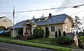
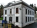
Astoria City Hall: A Glimpse of Government
The old Astoria City Hall building is another important historic site. It once served as the center of local government for the city.
_in_2012.jpg)
Astoria Column: A Tower with a View
The Astoria Column stands tall on Coxcomb Hill. This famous column tells stories of early explorers and settlers in the area through its unique spiral artwork. It offers amazing views of the Columbia River and the Pacific Ocean.
_(clatDA0084).jpg)
Astoria Downtown Historic District: A Walk Through Time
The Astoria Downtown Historic District covers a large area of Astoria's city center. It includes many buildings that show the city's history and how it developed. Walking through this district is like taking a step back in time.

Astoria Elks Building: A Community Hub
The Astoria Elks Building is another historic structure in Astoria. Buildings like this often served as important gathering places for community groups and events.

Astoria Fire House No. 2: Protecting the City
Astoria Fire House No. 2 was once a key part of Astoria's fire protection system. Firehouses are important historical buildings that show how communities organized to keep people safe.

Astoria Marine Construction Company: Building Ships
The Astoria Marine Construction Company Historic District is located near Astoria. This area was important for building and repairing ships, showing Astoria's strong connection to the water and its maritime history.

Astoria Victory Monument: Honoring Heroes
The Astoria Victory Monument stands as a tribute to important events and people in history. Monuments often help us remember and honor those who came before us.

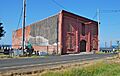
Astoria Wharf and Warehouse Company: River Trade
The Astoria Wharf and Warehouse Company was located along the Columbia River waterfront. Wharves and warehouses were essential for trade and transportation, allowing goods to be moved in and out of Astoria by boat.

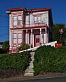
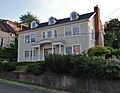
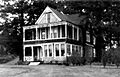
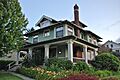
Robert Rensselaer Bartlett House: A Historic Home
The Robert Rensselaer Bartlett House is a historic home in Astoria. Many old houses are preserved because they show us the architectural styles and ways of life from different periods.

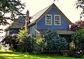
Peter L. Cherry House: Another Old Astoria Home
The Peter L. Cherry House is another example of a historic residence in Astoria. These homes help us understand the history of families and daily life in the city.

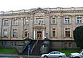
Clatsop County Courthouse: Local Justice
The Clatsop County Courthouse is where important legal and government decisions for the county are made. Courthouses are often grand buildings that represent justice and community order.

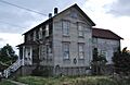
Old Clatsop County Jail: A Look at the Past
The Old Clatsop County Jail is a historic building that once served as the county's jail. It provides a glimpse into the history of law enforcement and the justice system.

Erickson–Larsen Ensemble: Two Old Buildings
The Erickson–Larsen Ensemble includes two historic buildings: a house built in 1877 and a small apartment building from around 1885. They show how people lived and built homes in Astoria long ago.
,_2012.jpg)
Albert W. Ferguson House: A Historic Residence
The Albert W. Ferguson House is another historic home in Astoria. Preserving these houses helps us appreciate the different styles of architecture from the past.

Ferdinand Fisher House: An Old Astoria Home
The Ferdinand Fisher House is a historic house in Astoria. It adds to the collection of well-preserved homes that tell the story of the city's development.

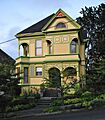
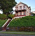
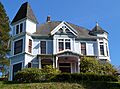
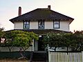
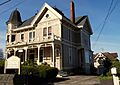
Capt. George Flavel House: A Museum and Movie Star
The Capt. George Flavel House and Carriage House is a beautiful Queen Anne style home built in 1885. Today, it's a house museum where you can learn about life in the late 1800s. This house was even featured in the famous movie The Goonies!

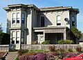
Captain George Conrad Flavel House: Another Flavel Home
The Captain George Conrad Flavel House was built in 1901. The Flavel family was very important in Astoria's history, and several of their homes are preserved.
_boarded-up,_2012.jpg)
George C. and Winona Flavel House: An 1879 Home
The George C. and Winona Flavel House was built in 1879. This house is another example of the historic homes connected to the prominent Flavel family in Astoria.

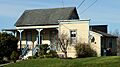
Martin Foard House: A Piece of Astoria's Past
The Martin Foard House is a historic building that contributes to the rich history of Astoria's architecture.

Fort Astoria: A Fur Trading Post
Fort Astoria was built in 1811 by John Jacob Astor. He wanted to challenge the British control over the fur trade in the Pacific Northwest. This fort became a very important part of the American claim to the Oregon Country. However, Astor later sold the fort to the British North West Company in 1813.

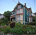
Rev. William S. Gilbert House: A Historic Residence
The Rev. William S. Gilbert House is another historic home in Astoria. It represents the architectural styles and community life of the past.

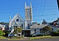
Grace Episcopal Church and Rectory: A Place of Worship
Grace Episcopal Church and Rectory is a historic church and its associated rectory (the home for the church's minister). Churches often play a central role in a community's history and social life.

Old Grace Episcopal Church Rectory: An Earlier Home
The Old Grace Episcopal Church Rectory is an earlier home for the church's minister. It's another important part of the church's history.

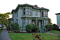
Capt. J. H. D. Gray House: A Captain's Home
The Capt. J. H. D. Gray House is a historic home that once belonged to Captain J. H. D. Gray. Homes of important figures often tell us about their lives and contributions to the community.

John N. Griffin House: An Old Astoria Home
The John N. Griffin House is another historic residence in Astoria. These well-preserved homes help us understand the city's past.

John Hobson House: A Historic Building
The John Hobson House is a historic building in Astoria. It's part of the many structures that make up the city's rich historical landscape.

Gustavus Holmes House: A Glimpse into the Past
The Gustavus Holmes House is another historic home in Astoria. It offers a look into the residential architecture of earlier times.

Peter and Maria Larson House: An Early Home
The Peter and Maria Larson House was built long ago in Astoria. It is a historic example of the homes from that period.

Christian Leinenweber House: A Historic Residence
The Christian Leinenweber House is another historic home in Astoria. It adds to the collection of buildings that tell the story of the city's past.

Lightship WAL-604, COLUMBIA: A Floating Lighthouse
The Lightship WAL-604, COLUMBIA was a special ship that acted like a floating lighthouse. It was retired in 1979 as the last lightship to be stationed at the Columbia Bar, a dangerous area where the Columbia River meets the ocean. This ship, built in 1950, is important because it's one of the best-preserved examples of the last generation of U.S. Coast Guard lightships.

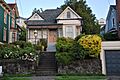
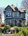
Noonan–Norblad House: A Historic Home
The Noonan–Norblad House is another historic residence in Astoria. It's part of the city's collection of important old buildings.

Judge C. H. Page House: A Judge's Residence
The Judge C. H. Page House was the home of Judge C. H. Page. Homes of important community members often have interesting stories to tell about their lives and the times they lived in.

Shively–McClure Historic District: A Neighborhood's History
The Shively–McClure Historic District is a neighborhood in Astoria with many historic buildings. It shows how residential areas developed over time.
_2.jpg)
Norris Staples House: An Old Astoria Home
The Norris Staples House is another historic home in Astoria, contributing to the city's preserved architectural heritage.

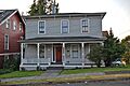
Charles Stevens House: A Historic Residence
The Charles Stevens House is a historic home in Astoria. It's one of many buildings that help tell the story of the city's past.

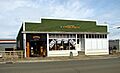
Svenson Blacksmith Shop: A Place of Craftsmanship
The Svenson Blacksmith Shop was a place where blacksmiths worked, shaping metal to create tools and other items. Blacksmith shops were vital businesses in early communities.

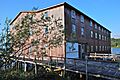
Union Fishermen's Cooperative Packing Company Alderbrook Station: Fishing History
The Union Fishermen's Cooperative Packing Company Alderbrook Station was an important part of Astoria's fishing industry. It shows the history of how fish were caught and processed in the area.

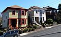
Uniontown–Alameda Historic District: A Historic Neighborhood
The Uniontown–Alameda Historic District is another historic neighborhood in Astoria. It contains many buildings that reflect the city's development.
_(clatDA0065a).jpg)
U.S. Post Office and Custom House: Mail and Trade
The U.S. Post Office and Custom House in Astoria served as both a place for mail and for customs, where goods entering the country were checked. It was a very important building for communication and trade.

Warren Investment Company Housing Group: Early Housing
The Warren Investment Company Housing Group includes several historic homes. These houses show how housing was developed for workers and families in the past.

Andrew Young House and Benjamin Young House: Family Homes
The Andrew Young House and the Benjamin Young House and Carriage House are two historic homes in Astoria. They belonged to members of the Young family, showing their presence and history in the community.


Historic Sites Beyond Astoria
Fort Clatsop National Memorial: Lewis and Clark's Winter Camp
Fort Clatsop National Memorial is located south of Astoria. This site is a replica of the fort where the famous explorers Lewis and Clark and their team spent the winter of 1805-1806. It's a great place to learn about their journey and early American exploration.

Fort Stevens: A Coastal Defense
Fort Stevens is located in Fort Stevens State Park near Hammond. This fort was a military defense site, protecting the mouth of the Columbia River for many years. It played a role in both World War I and World War II.

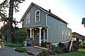
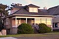
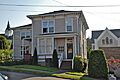
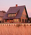
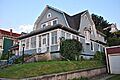
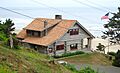
William and Nellie Fullam House: A Seaside Home
The William and Nellie Fullam House is a historic home located in Seaside. Seaside is a popular coastal town, and its historic homes reflect its development as a resort area.

Goodwin–Wilkinson Farmhouse: Rural History
The Goodwin–Wilkinson Farmhouse is located near Warrenton. This farmhouse represents the agricultural history of Clatsop County and how farming families lived.

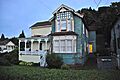
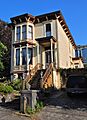
Haller–Black House: Another Seaside Gem
The Haller–Black House is another historic home in Seaside. It adds to the charm and history of this coastal community.

Charles David Latourette House: A Gearhart Home
The Charles David Latourette House is located in Gearhart, another coastal town in Clatsop County. This home is part of Gearhart's historic architecture.

Charles Preston House: A Seaside Residence
The Charles Preston House is a historic home in Seaside. It's another example of the older buildings that make Seaside unique.

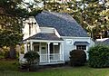
Sea Lyft: A Historic Building in Gearhart
The Sea Lyft is a historic building in Gearhart. It contributes to the historical character of the town.

Tillamook Rock Lighthouse: A Lighthouse on a Rock
The Tillamook Rock Lighthouse is a famous lighthouse located southwest of Seaside on a rocky island. This lighthouse, built in 1881, is known for its dramatic location and long history of guiding ships.

Daniel Knight Warren House: A Warrenton Home
The Daniel Knight Warren House is a historic home in Warrenton. It's part of the historical fabric of this community.

Oswald West Coastal Retreat: A Special Getaway
The Oswald West Coastal Retreat is located in Cannon Beach. This retreat was once owned by Oswald West, a former governor of Oregon. It's a historic place connected to an important figure in the state's history.

Archaeological Sites
Clatsop County also has important archaeological sites that tell us about the earliest people who lived here. These sites are often protected to preserve their valuable information.
Bald Point Site (35CLT23): Ancient Tillamook Life
The Bald Point Site (35CLT23) near Cannon Beach is an archaeological site linked to the Tillamook people. It has a shell midden (a pile of shells and other waste from ancient meals) and possibly a house pit, dating back to about 1550 CE. Some parts of the site have been lost to coastal erosion, but much of it remains.
Ecola Point Site (35CLT21): A Large Village Site
The Ecola Point Site (35CLT21), also near Cannon Beach, contains the remains of a Tillamook village and two large shell middens. Scientists have dated this site to be from about 1100 to 1700 CE. This large and complex site is mostly untouched, and it holds a lot of potential for future research to learn more about the past.
Former Listings
Some places that were once on the National Register of Historic Places have been removed for various reasons, such as being destroyed or moved.
Samuel Elmore Cannery: The Home of Bumble Bee Tuna
The Samuel Elmore Cannery in Astoria was once the longest continuously-operated salmon cannery in the U.S. It opened in 1898 and started canning tuna in the 1930s, becoming the home of "Bumble Bee" tuna. Sadly, the cannery closed in 1980 and then burned down in 1993, so it is no longer on the list.

Allan Herschell Two-Abreast Carousel: A Moving Carousel
The Allan Herschell Two-Abreast Carousel was once in Seaside. This historic carousel was moved to California in 1991 and is now in storage in Ohio, so it was removed from the list.
Images for kids
-
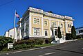
The old Astoria City Hall.
-
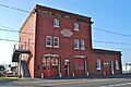
Astoria Fire House No. 2.
-
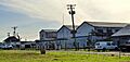
The Astoria Marine Construction Company.
-
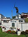
The Astoria Victory Monument.
-
The Astoria Wharf and Warehouse Company building.
-
The Robert Rensselaer Bartlett House.
-
The Peter L. Cherry House.
-
The Clatsop County Courthouse.
-
The Old Clatsop County Jail.
-
The Albert W. Ferguson House.
-
The Ferdinand Fisher House.
-

The Captain George Conrad Flavel House.
-
The George C. and Winona Flavel House.
-
The Martin Foard House.
-
The William and Nellie Fullam House in Seaside.
-
The Rev. William S. Gilbert House.
-
The Goodwin–Wilkinson Farmhouse.
-
Grace Episcopal Church and Rectory.
-
The Old Grace Episcopal Rectory.
-
The Capt. J. H. D. Gray House.
-
The John N. Griffin House.
-
The Haller–Black House in Seaside.
-
The John Hobson House.
-
The Gustavus Holmes House.
-
The Peter and Maria Larson House.
-
The Charles David Latourette House in Gearhart.
-
The Christian Leinenweber House.
-
The Noonan–Norblad House.
-
The Judge C. H. Page House.
-
The Charles Preston House in Seaside.
-
The Sea Lyft building in Gearhart.
-
The Norris Staples House.
-
The Charles Stevens House.
-
The Svenson Blacksmith Shop.
-
The Union Fishermen's Cooperative Packing Company Alderbrook Station.
-
One of the homes in the Warren Investment Company Housing Group.
-
The Daniel Knight Warren House in Warrenton.
-
The Oswald West Coastal Retreat.
-
The Andrew Young House.
-
The Benjamin Young House and Carriage House.
