
National Register of Historic Places listings in Yamhill County, Oregon facts for kids
Yamhill County, located in Oregon, is home to many special places listed on the National Register of Historic Places. These places are buildings, sites, or objects that are important to the history of the United States. They are protected and recognized for their unique stories and how they show us what life was like in the past.
There are 85 historic places in Yamhill County that are currently on the National Register. Let's explore some of them!
Contents
Historic Places in Yamhill County
Cool Buildings to See
Many of the historic places in Yamhill County are old houses and buildings. They tell us about the people who lived and worked there long ago.
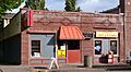
- 99W Drive-in Theatre in Newberg: This is a classic drive-in movie theater where you can watch movies from your car! It was added to the list in 2014.
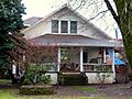
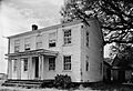
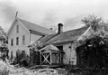
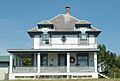
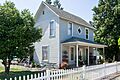
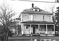
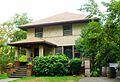
- Avery House in Dayton: This historic house is located on Church Street.
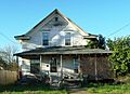
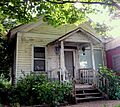
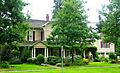
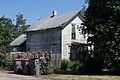
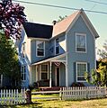
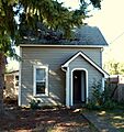
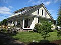
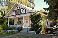
- Baxter House in Dayton: Another historic house on Church Street in Dayton.
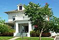
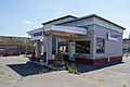
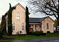
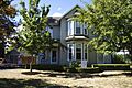
- Berry–Sigler Investment Property in Dayton: This property was added to the list in 1987.
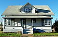
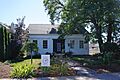
- Henry Bertram, Sr. House in Dayton: This house is on Webfoot Road.
- Buchanan Cellers Mill in McMinnville: This old mill was added to the Register in 2012.
- John Marion Bunn House in Yamhill: This house was listed in 1979.
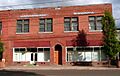
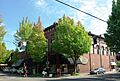
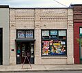
- Carlton State and Savings Bank in Carlton: This old bank building is on West Main Street.
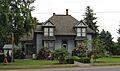
- Carter–Goodrich House in Dayton: You can find this house on Church Street.
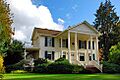
- Asa F. Cate Farm Ensemble in McMinnville: This farm was recognized in 1990.
- Joseph and Virginia Chambers Farmstead in Newberg: This historic farm is located on Highway 99W.
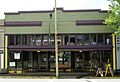
- Commercial Club – S. C. Stuckey Building in Dayton: This building is on Ferry Street.
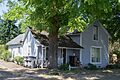
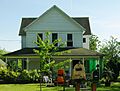
- Amos Cook House in Dayton: This house is located northwest of Dayton.
- Carl Fischer Meats in Dayton: This old meat shop is on Ferry Street.
- Alfred P. Fletcher Farmhouse in Lafayette: This farmhouse was listed in 1980.
- Francis Fletcher House in Dayton vicinity: This house is west of Dayton.
- Fletcher–Stretch House in Dayton: This house is on Oak Street.
- Foster Oil Company in Dayton: This old oil company building is on Ferry Street.
- Gabriel–Filer House in Dayton: This house is on Church Street.
- Gabriel–Will House in Dayton: This house is on 3rd Street.
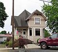
- Levi Hagey House in Dundee: This house is located off Highway 99W.
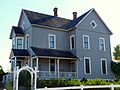
- Harrington House in Dayton: This house is on Mill Street.
- Harris Building in Dayton: This building is on Ferry Street.
- William Hibbert House in Dayton: This house is on 5th Street.
- Hole House in Dayton: This house is on Ferry Street.
- J. C. Penney Building in Newberg: This old department store building is on East 1st Street.
- Jessen–Goodrich House in Dayton: This house is on 6th Street.
- James M. and Paul R. Kelty House in Lafayette: This house is on 3rd Street.
- Dr. Andrew Kershaw House in Willamina: This house is on East Main Street.
- Krietz House in Dayton: This house is on Church Street.
- Lamson Ranch in Willamina vicinity: This ranch was added to the Register in 2013.
- Lee Laughlin House in Yamhill: This house is on South Laurel Street.
- Lewis–Shippy House in Dayton: This house is on 6th Street.
- Gottlieb Londershausen House in Dayton: This house is on Main Street.
- Paul Londershausen House in Dayton: This house is on Main Street.
- Mabee–Mayberry House in Dayton: This house is on 7th Street.
- Joseph Mattey House in Lafayette: This house is west of Lafayette.
- McNamar Building in Dayton: This building is on Ferry Street.
- Mellinger House in Dayton: This house is on 5th Street.
- Mellinger–Ponnay House in Dayton: This house is on Tribbett Court.
- Monahan House in Dayton: This house is on 5th Street.
- Robert Morse House in Dayton: This house is on Oak Street.
- Benjamin F. Morse House in Dayton: This house is on 5th Street.
- Oregon Mutual Merchant Fire Insurance Association Office in Dayton: This office building is on Ferry Street.
- William Albert and Anna May Bristow Parrish Farmstead in Newberg: This farm was listed in 2000.
- Paulson–Gregory House in Newberg: This house is on South College Street.
- Curtis W. Powell House in Dayton: This house is on Ash Street.
- Rippey House in Dayton: This house is on Ash Street.
- Sigler House in Dayton: This house is on Ferry Street.
- Andrew Smith House in Dayton: This house is on 5th Street.
- John T. Smith House in Newberg: This house is on North College Street.
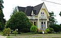
- Charles K. Spaulding House in Newberg: This was the home of Charles K. Spaulding, a famous timber businessman.
- Jack Spence House in McMinnville: This house is on NE 5th Street.
- Dr. Stuart House in Dayton: This house is on Ferry Street.
- Travelers Home in Sheridan: This building is on NE Yamhill Street.
- Union Block in Newberg: This block of buildings is on East 1st Street.
Schools and Churches
Some of the oldest buildings in Yamhill County are schools and churches, which played a big part in the community's early days.
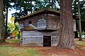
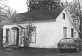
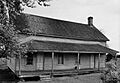
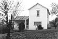
- Briedwell School in Amity: Built in 1895, this is one of the best-preserved one-room schoolhouses in Yamhill County. It taught students from kindergarten to 8th grade until 1957. Today, it's a house, but it reminds us of the old railroad town of Briedwell.
- Dayton Common School in Dayton: This old school building is on 4th Street.
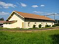
- Dayton High School in Dayton: This historic high school building is on Ferry Street.
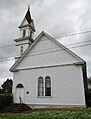
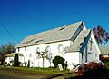
- Dayton Methodist Episcopal Church in Dayton: This church is on 4th Street.
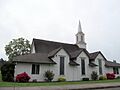
- Evangelical Church of Lafayette in Lafayette: This church is on Market Street.
- Evangelical United Brethren Church in Dayton: This church is on 5th Street.
- First Baptist Church in Dayton: This church is located at 3rd and Main Streets.
- Free Methodist Church in Dayton: This church is on Oak Street.
- Methodist Episcopal Parsonage in Dayton: This parsonage (a house for a minister) is on 4th Street.
- Minthorn Hall in Newberg: This hall is on the George Fox University Campus.
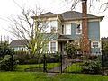
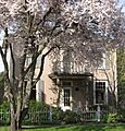
- Dr. Henry J. Minthorn House (Herbert Hoover House) in Newberg: This was the home of Dr. Henry J. Minthorn, where future U.S. President Herbert Hoover lived as a child.
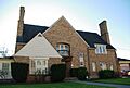
- Pioneer Hall, Linfield College in McMinnville: This historic building is on the Linfield College campus.
Parks and Other Sites
Not all historic places are buildings. Some are parks or other important locations.
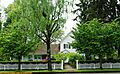
- Brookside Cemetery in Dayton: This historic cemetery is at the south end of 3rd Street.
- Courthouse Square Park in Dayton: This park is surrounded by 3rd, 4th, Ferry, and Main Streets. It's a central part of Dayton's history.
- Fernwood Pioneer Cemetery in Newberg: This pioneer cemetery is on Everest Road.
- McMinnville Downtown Historic District in McMinnville: This area includes many historic buildings in downtown McMinnville.
- Palmer House in Dayton: This house is on Ferry Street.
- Yamhill River Lock and Dam in Dayton: This lock and dam structure is across the Yamhill River. It was important for river travel long ago.
- Ewing Young Site in Newberg: This site is a special historical location, though its exact address is kept private to protect it.
Places No Longer Listed
Sometimes, a historic place might be removed from the National Register. This can happen if the building is changed too much, or if it is torn down.
- Dayton Auto and Transfer Company Building in Dayton: This building was on Ferry Street but was removed from the list in 1998.
- Dayton Opera House in Dayton: This opera house was also on Ferry Street and was removed from the list in 1998.
Images for kids
-
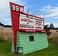
The sign for the 99W Drive-in Theatre.
-
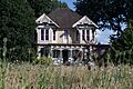
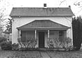
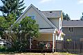
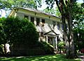
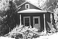
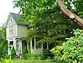
The historic Avery House in Dayton.
-
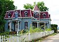
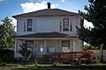
The Baxter House in Dayton.
-
The Berry-Sigler Investment Property.
-
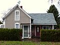
The Henry Bertram, Sr. House.
-

The Briedwell School, a historic one-room schoolhouse.
-
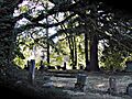
Brookside Cemetery in Dayton.
-
The Buchanan Cellers Mill.
-
The John Marion Bunn House.
-
The Cain House, which has since been demolished.
-
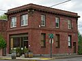
The Carlton State and Savings Bank building.
-
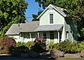
The Carter–Goodrich House.
-

The Asa F. Cate Farm Ensemble.
-
The Joseph and Virginia Chambers Farmstead.
-
The Commercial Club – S. C. Stuckey Building.
-
The Amos Cook House.
-
A view of Courthouse Square Park.
-
The Dayton Common School.
-

Dayton High School.
-
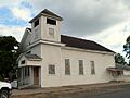
The Dayton Methodist Episcopal Church.
-
The Diehl–Seitters House, which has been demolished.
-
The Dundee Woman's Club Hall.
-
The Jesse Edwards House.
-
The Evangelical Church of Lafayette.
-
The Evangelical United Brethren Church.
-
The Frank W. Fenton House.
-

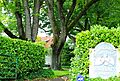
Fernwood Pioneer Cemetery.
-
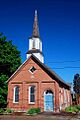
The First Baptist Church in Dayton.
-
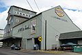
Carl Fischer Meats building.
-

The Alfred P. Fletcher Farmhouse.
-
The Francis Fletcher House.
-
The Fletcher–Stretch House.
-
The Foster Oil Company building.
-
The Free Methodist Church.
-
The Gabriel–Filer House.
-
The Gabriel–Will House.
-
The Levi Hagey House.
-
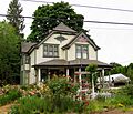
The Harrington House.
-
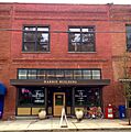
The Harris Building.
-
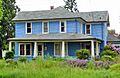
The William Hibbert House.
-
The Hole House.
-
The J. C. Penney Building in Newberg.
-
The Jessen–Goodrich House.
-
The James M. and Paul R. Kelty House.
-
The Dr. Andrew Kershaw House.
-
The Krietz House.
-
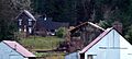
The Lamson Ranch.
-
The Lee Laughlin House.
-
The Lewis–Shippy House.
-
The Gottlieb Londershausen House.
-
The Paul Londershausen House.
-
The Mabee–Mayberry House.
-

The Joseph Mattey House.
-
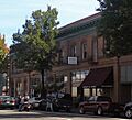
Downtown McMinnville Historic District.
-

The McNamar Building.
-
The McNish House, which no longer exists.
-
The Mellinger House.
-
The Mellinger–Ponnay House.
-
The Methodist Episcopal Parsonage.
-
Minthorn Hall at George Fox University.
-

The Dr. Henry J. Minthorn House (Herbert Hoover House).
-
The Monahan House.
-
The Robert Morse House.
-
The Benjamin F. Morse House.
-
The Nichols House, which no longer exists.
-
The Oregon Mutual Merchant Fire Insurance Association Office.
-
The Palmer House.
-
The William Albert and Anna May Bristow Parrish Farmstead.
-
The Paulson–Gregory House.
-

Pioneer Hall at Linfield College.
-
The Curtis W. Powell House.
-
The Rippey House.
-

The Sigler House.
-
The Andrew Smith House.
-

The John T. Smith House.
-
The Charles K. Spaulding House.
-
The Jack Spence House.
-
The Dr. Stuart House.
-
The Travelers Home.
-
The Union Block in Newberg.
-
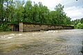
The Yamhill River Lock and Dam.
-
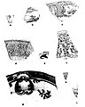
An artifact from the Ewing Young Site.


.jpg)


_(yamDA0084).jpg)

_(yamDA0070).jpg)


_(yamDA0025b).jpg)


.jpg)
.jpg)


.jpg)


.jpg)


.jpg)


.jpg)


_(yamDA0073).jpg)


_(yamDA0112).jpg)


