
National Register of Historic Places listings in Polk County, Oregon facts for kids
The National Register of Historic Places is like a special list of important buildings, places, and objects in the United States. These places are chosen because they have a lot of history, special architecture, or are important to how our country developed. When a place is on this list, it means it's recognized as a valuable part of our shared past and should be protected.
In Polk County, Oregon, there are many amazing places on this list. They tell stories about the people who lived here long ago, how they built their homes, worked, and created communities. Let's explore some of these cool historic spots!
Contents
Historic Places in Polk County
Polk County is home to many buildings and sites that have been recognized for their historical importance. These range from old churches and houses to bridges and even a former military fort.
Homes with History
Many of the places on the list are old houses. These homes often show us how people lived and what kind of styles were popular many years ago.
- Beulah Methodist Episcopal Church: This church in Falls City was added to the list in 2002. It's a beautiful old building that served as an important community gathering place.
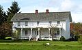
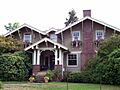
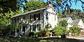
- Harrison Brunk House: Located in Brunks Corner, this house was listed in 1975. It's a great example of early homes in the area.
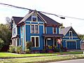
- James S. and Jennie M. Cooper House: You can find this house in Independence. It was recognized in 1988.
- Joseph and Priscilla Craven House: This historic home in Monmouth joined the list in 1998.
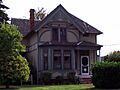
- Dr. John E. and Mary D. Davidson House: Another historic home in Independence, listed in 1985.
- Walter J. Domes House: This house near Rickreall was added in 1990.
- Kersey C. Eldridge House: An Independence home listed in 1988.
- Graves–Fisher–Strong House: This house in Monmouth was listed in 1985.
- Jesse and Julia Harritt House: Located near Salem, this house joined the list in 1999.
- John W. Howell House: Another Monmouth home, listed in 1987.
- John Phillips House: This house is northwest of Salem and was listed in 1976.
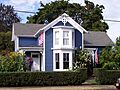
- Riley–Cutler House: Found near Monmouth, this house was added in 1980.
- Edward W. St. Pierre House: This house near Salem was listed in 1989.
- Eleanor Sherman House: A Monmouth home recognized in 1989.
- George A. Wells Jr. House: This house near Independence was listed in 1981.
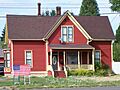
- J. A. Wheeler House: An Independence home added in 1986.
Important Community Buildings
Beyond homes, other buildings that played a big role in the community's daily life are also on the list.
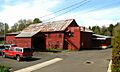
- Dallas Tannery: In Dallas, this old tannery was listed in 1980. A tannery is a place where animal hides are turned into leather.
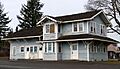
- Grand Ronde Rail Depot: This old train station in Grand Ronde was added to the list in 2012. Train depots were once very busy places!
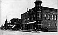
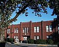
- Independence Historic District: This isn't just one building, but a whole area in Independence that has many historic buildings. It was recognized in 1989.
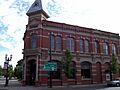
- Independence National Bank: This bank building in Independence was listed in 1986.
- Parker School: An old school building near Independence, listed in 1989.
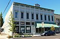
- Polk County Bank: This bank building in Monmouth was added in 1986.
- Saint Patrick's Roman Catholic Church: This church in Independence was listed in 1987.
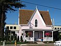
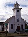
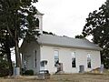
- Spring Valley Presbyterian Church: Located southeast of McCoy, this church was added in 1974.
- Old West Salem City Hall: This former city hall building in Salem was listed in 1990.
- A. K. Wilson Building: This building in Dallas was recognized in 1998.
Bridges and Other Structures
Some structures like bridges are also important parts of history.
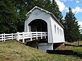
- Ritner Creek Bridge: This bridge south of Pedee was listed in 1979.
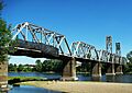
- Union Street Railroad Bridge and Trestle: This railroad bridge in Salem was added in 2006. It's also important to Marion County.
Fort Yamhill Site
- Fort Yamhill Site: This site near Grand Ronde was listed way back in 1971. It was once a military fort.
Former Listings
Sometimes, a place that was on the National Register of Historic Places might be removed from the list. This usually happens if the building or structure is destroyed or changed so much that it no longer has its historic value.
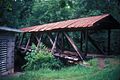
- Pumping Station Bridge: This bridge near Ellendale was listed in 1979 but was removed in 1987 because it collapsed.
Images for kids
-
The Harrison Brunk House.
-
The James S. and Jennie M. Cooper House.
-
The Joseph and Priscilla Craven House.
-
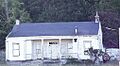
The Dallas Tannery.
-

The Dr. John E. and Mary D. Davidson House.
-

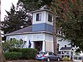
The Walter J. Domes House.
-
The Kersey C. Eldridge House.
-
The Fort Yamhill Site.
-
The Grand Ronde Rail Depot.
-
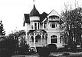
The Graves–Fisher–Strong House.
-
The Jesse and Julia Harritt House.
-
The John W. Howell House.
-
A view of the Independence Historic District.
-
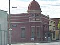
The Independence National Bank building.
-
The Parker School.
-
The John Phillips House.
-
The Polk County Bank building.
-
The Riley–Cutler House.
-
The Ritner Creek Bridge.
-
Saint Patrick's Roman Catholic Church.
-
The Edward W. St. Pierre House.
-

The Eleanor Sherman House.
-
The Spring Valley Presbyterian Church.
-
The Union Street Railroad Bridge and Trestle.
-

The George A. Wells Jr. House.
-
The Old West Salem City Hall.
-
The J. A. Wheeler House.
-
The A. K. Wilson Building.
-
The Pumping Station Bridge, which later collapsed.


See also
- National Register of Historic Places listings in Oregon
- Listings in neighboring counties: Benton, Lincoln, Linn, Marion, Tillamook, Yamhill
- Historic preservation
- History of Oregon
- Lists of Oregon-related topics
External links
- Oregon Parks and Recreation Department, National Register Program
- National Park Service, National Register of Historic Places site
