Newman Grove, Nebraska facts for kids
Quick facts for kids
Newman Grove, Nebraska
|
|
|---|---|

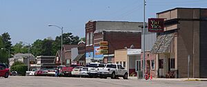
Downtown Newman Grove: north side of Hale Avenue, May 2010
|
|

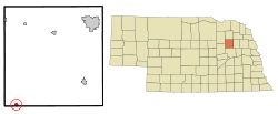
Location in Madison County and the state of Nebraska
|
|
| Country | United States |
| State | Nebraska |
| Counties | Madison, Platte |
| Area | |
| • Total | 0.55 sq mi (1.41 km2) |
| • Land | 0.55 sq mi (1.41 km2) |
| • Water | 0.00 sq mi (0.00 km2) |
| Elevation | 1,745 ft (532 m) |
| Population
(2020)
|
|
| • Total | 667 |
| • Density | 1,223.85/sq mi (472.45/km2) |
| Time zone | UTC-6 (Central (CST)) |
| • Summer (DST) | UTC-5 (CDT) |
| ZIP code |
68758
|
| Area code(s) | 402 |
| FIPS code | 31-34230 |
| GNIS feature ID | 838343 |
Newman Grove is a small city in Nebraska, United States. It is located in both Madison and Platte counties. In 2020, about 667 people lived there. It is considered part of the Norfolk Micropolitan Statistical Area.
History
Newman Grove was officially started in 1887. This happened when a railroad, called the Fremont, Elkhorn and Missouri Valley Railroad, reached that spot. The city was named after Newman Warren. He had planted a group of trees nearby, which became known as "Newman's Grove."
Geography
Newman Grove is mostly in southwestern Madison County. A small part of it also goes into Platte County. Nebraska Highway 45 runs through the city as 8th Street. This highway goes north for about 23 miles (37 km) to Tilden. It goes south for about 3 miles (5 km) to where it ends at Nebraska Highway 91. Madison, which is the county seat of Madison County, is about 22 miles (35 km) northeast. You can get there using Highways 45 and 32.
The U.S. Census Bureau says that Newman Grove covers a total area of 0.55 square miles (1.41 square kilometers). All of this area is land. Shell Creek flows along the northern edge of the city. This creek then flows southeast to join the Platte River east of Schuyler.
Population Data
| Historical population | |||
|---|---|---|---|
| Census | Pop. | %± | |
| 1890 | 330 | — | |
| 1900 | 696 | 110.9% | |
| 1910 | 850 | 22.1% | |
| 1920 | 1,260 | 48.2% | |
| 1930 | 1,146 | −9.0% | |
| 1940 | 1,036 | −9.6% | |
| 1950 | 1,004 | −3.1% | |
| 1960 | 880 | −12.4% | |
| 1970 | 863 | −1.9% | |
| 1980 | 930 | 7.8% | |
| 1990 | 787 | −15.4% | |
| 2000 | 797 | 1.3% | |
| 2010 | 721 | −9.5% | |
| 2020 | 667 | −7.5% | |
| U.S. Decennial Census | |||
Population in 2010
Based on the census from 2010, there were 721 people living in Newman Grove. These people lived in 320 households. The city had about 1311 people per square mile (506 people per square kilometer).
Most of the people living in the city were White (91.1%). A small number were Hispanic or Latino (10.1%). The average household had 2.15 people. The average family had 2.86 people. The median age in the city was 50.1 years old.
Education
The public schools in Newman Grove are part of the Newman Grove Public Schools district. This district serves students from kindergarten all the way through 12th grade.
Religion
There are five churches in Newman Grove. These include Newman Grove United Methodist Church, Trinity Lutheran Church, Zion Shell Creek Salem Church, Zion Evangelical Lutheran Church, and Fellowship Bible Church.
See also
 In Spanish: Newman Grove (Nebraska) para niños

