Nili, Afghanistan facts for kids
Quick facts for kids
Nili
نیلی
|
|
|---|---|
|
City
|
|

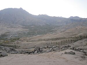
A distant view of Nili in 2011
|
|
| Country | |
| Province | Daykundi |
| District | Nili |
| Elevation | 2,022 m (6,634 ft) |
| Population
(2022)
|
|
| • Total | 30,058 |
| Time zone | UTC+4:30 (AFT) |
Nili (Dari: نیلی; Pashto: نیلي) is a city located in the middle of Afghanistan. It has been the main city, or capital, of Daykundi Province since 2004. Nili is connected by roads to other important places like Bamyan and Tarinkot.
About 30,000 people live in Nili, based on a 2022 estimate. Most of the people here are from the Hazaras ethnic group. There are also smaller groups like Pashtuns and others.
The city has over 2,000 homes and shops. It is part of the Nili District and the Hazarajat region. Nili sits high up, about 2,022 meters (6,634 feet) above sea level. The Nili Airport is just a few miles from the city center, which is known as Gul-e-Badam Square (Almond Square).
Nili is like a big village where much of the land is not built on. Empty land makes up about 79% of the total area. Only a small part, about 239 hectares, has buildings. Of this built-up area, 35% is for homes and 40% is empty plots ready for building.
Contents
Nili's Past: A Look at Its History
Nili became the capital of Daykundi Province in March 2004. Before that, it was just a regular town in the larger Uruzgan Province. Because it was hard to reach and had very cold winters, the United Nations didn't open an office there until April 2007.
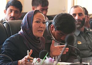
In December 2008, the President of Afghanistan, Hamid Karzai, chose Azra Jafari to be the mayor of Nili. This made her the first female mayor in all of Afghanistan.
On August 14, 2021, Nili was taken over by Taliban forces. It was the twenty-fourth provincial capital they captured during their 2021 offensive.
Nili's Weather: Climate and Seasons
Nili has a type of climate called a hot-summer humid continental climate. This means it has dry summers and cold winters with lots of snow. Most of the rain and snow falls in spring and winter.
| Climate data for Nili, Daykundi Province | |||||||||||||
|---|---|---|---|---|---|---|---|---|---|---|---|---|---|
| Month | Jan | Feb | Mar | Apr | May | Jun | Jul | Aug | Sep | Oct | Nov | Dec | Year |
| Mean daily maximum °C (°F) | −1.7 (28.9) |
0.0 (32.0) |
6.1 (43.0) |
15.6 (60.1) |
21.7 (71.1) |
27.8 (82.0) |
31.1 (88.0) |
30.0 (86.0) |
26.1 (79.0) |
18.9 (66.0) |
9.4 (48.9) |
3.3 (37.9) |
15.7 (60.2) |
| Daily mean °C (°F) | −6.9 (19.6) |
−4.7 (23.5) |
1.4 (34.5) |
9.8 (49.6) |
15.6 (60.1) |
21.4 (70.5) |
24.7 (76.5) |
23.4 (74.1) |
19.2 (66.6) |
12.5 (54.5) |
3.9 (39.0) |
−2.5 (27.5) |
9.8 (49.7) |
| Mean daily minimum °C (°F) | −12.2 (10.0) |
−9.4 (15.1) |
−3.3 (26.1) |
3.9 (39.0) |
9.4 (48.9) |
15.0 (59.0) |
18.3 (64.9) |
16.7 (62.1) |
12.2 (54.0) |
6.1 (43.0) |
−1.7 (28.9) |
−8.3 (17.1) |
3.9 (39.0) |
| Average precipitation mm (inches) | 62 (2.4) |
105 (4.1) |
102 (4.0) |
72 (2.8) |
37 (1.5) |
1 (0.0) |
1 (0.0) |
0 (0) |
0 (0) |
2 (0.1) |
46 (1.8) |
25 (1.0) |
453 (17.7) |
| Source: Nomadseason | |||||||||||||
Nili's Economy: How People Make a Living
The people of Nili earn money mainly through agriculture (farming), trade, and transportation. Some income also comes from tourism and money sent from family members working elsewhere. The area is well-known for growing delicious almonds. The Sukhtok Dam is located a few miles east of the city.
Sports in Nili: Popular Activities
Association football (soccer) and cricket are the most popular sports played in Nili. The Nili Football Stadium is located close to the Nili Airport.
See also
 In Spanish: Nili para niños
 | Janet Taylor Pickett |
 | Synthia Saint James |
 | Howardena Pindell |
 | Faith Ringgold |


