Niota, Tennessee facts for kids
Quick facts for kids
Niota, Tennessee
|
|
|---|---|

Niota
|
|
| Nickname(s):
socktown
|
|

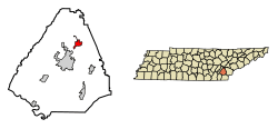
Location of Niota in McMinn County, Tennessee.
|
|
| Country | United States |
| State | Tennessee |
| County | McMinn |
| Settled | 1850s |
| Incorporated | 1911 |
| Named for | Ni-o-tah, a fictional Indian chief |
| Area | |
| • Total | 2.30 sq mi (5.95 km2) |
| • Land | 2.30 sq mi (5.95 km2) |
| • Water | 0.00 sq mi (0.00 km2) |
| Elevation | 1,007 ft (307 m) |
| Population
(2020)
|
|
| • Total | 772 |
| • Density | 335.94/sq mi (129.69/km2) |
| Time zone | UTC-5 (Eastern (EST)) |
| • Summer (DST) | UTC-4 (EDT) |
| ZIP code |
37826
|
| Area code(s) | 423 |
| FIPS code | 47-53380 |
| GNIS feature ID | 1648566 |
Niota is a small city in McMinn County, Tennessee, United States. In 2020, about 772 people lived there. Niota is known for its interesting history. It has a very old train station and a special story about women in local government.
Contents
History of Niota
People first settled in this area in the 1850s. They called the place "Mouse Creek." In 1897, the name changed to Niota. This happened because another train stop, "Mossy Creek" in Jefferson City, was causing confusion.
The name "Niota" came from a character in an old adventure book. This character was a made-up Native American chief named "Nee-o-tah."
Tennessee's Oldest Train Station
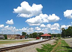
Niota is home to a special building called the Niota Depot. It was built in 1854 for the East Tennessee and Georgia Railroad. Today, it is famous for being the oldest train station still standing in Tennessee.
The Amazing "Golden Girls" of Niota
In 1988, something amazing happened in Niota. A group of women, known as the "Golden Girls of Niota," decided to run for the city council. A city council is a group of people elected to make local laws and manage a city. These women formed their own group called the People’s Choice Party.
Their leader was Effie Lones. She was 78 years old when she was elected mayor. The mayor is the head of the city council. At that time, she was the oldest woman in the country to be elected to such a position. What made this group even more special was that every member was a grandmother!
They won the election, which was a big deal. Niota became one of the first places in the U.S. with an all-female city council. It was the only one like it at that time. Four of these women were elected through "write-in votes." This means voters wrote their names on the ballot, even though their names were not printed there. The "Golden Girls" gave out sample ballots to help people understand how to do this.
Where is Niota Located?
Niota is in the eastern part of Tennessee. You can find its exact spot on a map using these coordinates: 35°30′51″N 84°32′50″W / 35.51417°N 84.54722°W.
The city is located along US Route 11. This road connects Niota to nearby towns like Sweetwater and Athens. Another road, Tennessee State Route 309, links Niota to Interstate 75. Interstate 75 is a major highway to the west.
Niota covers about 2.0 square miles (5.95 square kilometers). All of this area is land. There are no large lakes or rivers within the city limits.
Niota's Population
The government counts how many people live in different places using a census. This helps us learn about the community. Here's how Niota's population has changed over the years:
| Historical population | |||
|---|---|---|---|
| Census | Pop. | %± | |
| 1920 | 467 | — | |
| 1930 | 443 | −5.1% | |
| 1940 | 623 | 40.6% | |
| 1950 | 956 | 53.5% | |
| 1960 | 679 | −29.0% | |
| 1970 | 629 | −7.4% | |
| 1980 | 765 | 21.6% | |
| 1990 | 745 | −2.6% | |
| 2000 | 781 | 4.8% | |
| 2010 | 719 | −7.9% | |
| 2020 | 772 | 7.4% | |
| Sources: | |||
2020 Census Data
The 2020 United States census showed that 772 people lived in Niota. These people lived in 390 different homes, called households. Out of these, 255 were families.
Here’s a look at the different backgrounds of people in Niota in 2020:
| Race | Number | Percentage |
|---|---|---|
| White (not Hispanic) | 677 | 87.69% |
| Black or African American (not Hispanic) | 8 | 1.04% |
| Native American | 3 | 0.39% |
| Asian | 16 | 2.07% |
| Pacific Islander | 1 | 0.13% |
| Other backgrounds or Mixed Race | 42 | 5.44% |
| Hispanic or Latino (any race) | 25 | 3.24% |
2000 Census Data
In the year 2000, a census found that 781 people lived in Niota. There were 344 households, and 231 of these were families.
- People's Backgrounds: Most people in Niota (about 91 out of 100) identified as White. A smaller number identified as African American or Asian. Some people identified with two or more backgrounds. About 3 out of 100 people identified as Hispanic or Latino.
- Households: About 29 out of 100 homes had children younger than 18. More than half of the households (about 55 out of 100) were married couples living together.
- Ages of People: People of all ages lived in Niota. About 22 out of 100 residents were under 18 years old. About 16 out of 100 residents were 65 years old or older. The median age was 40 years. This means half the people were younger than 40 and half were older.
- Income: The typical income for a household in Niota was $28,750 per year. Some families and individuals had incomes below the poverty line. The poverty line is an amount of income set by the government. It helps measure if people have financial difficulty.
Education in Niota
Children in Niota go to public schools that are part of the McMinn County Schools system. Niota Elementary School is one of the schools located in the town.
Famous People from Niota
Some well-known people have connections to Niota:
- Harry T. Burn: He was born in Niota and lived there his whole life. Harry T. Burn was a member of the Tennessee General Assembly. This group makes laws for Tennessee. He is famous for a very important vote he made. His vote helped pass the Nineteenth Amendment to the United States Constitution. This amendment gave women in the United States the right to vote.
- Alfred Cate: He was a Tennessee state senator. A senator is a person elected to help create laws for the state. He was also known as a Southern Unionist. This means that even though he was from the South, he supported the United States government during the American Civil War.
See also
 In Spanish: Niota (Tennessee) para niños
 | Aaron Henry |
 | T. R. M. Howard |
 | Jesse Jackson |

