
Niverville, New York facts for kids
Quick facts for kids
Niverville, New York
|
|
|---|---|

Niverville, New York
Location in New York
|
|
| Country | United States |
| State | New York |
| County | Columbia |
| Towns | Kinderhook, Chatham |
| Settled | 1665 |
| Area | |
| • Total | 3.42 sq mi (8.86 km2) |
| • Land | 2.87 sq mi (7.44 km2) |
| • Water | 0.55 sq mi (1.41 km2) |
| Elevation | 292 ft (89 m) |
| Population
(2020)
|
|
| • Total | 1,508 |
| • Density | 524.70/sq mi (202.56/km2) |
| Time zone | UTC-5 (Eastern (EST)) |
| • Summer (DST) | UTC-4 (EDT) |
| ZIP code |
12130
|
| Area code(s) | 518 |
| FIPS code | 36-51297 |
Niverville is a small, mostly rural community in Columbia County, New York. It is known as a hamlet and a census-designated place (CDP). A hamlet is a small settlement, often without its own local government. A CDP is an area defined by the U.S. Census Bureau for statistical purposes.
Niverville is located in the town of Kinderhook. It sits just south of Kinderhook Lake. The Niverville CDP also includes the land around Kinderhook Lake. This area stretches east into the town of Chatham. In 2020, about 1,508 people lived in Niverville.
Contents
History of Niverville
Niverville was first settled by the Dutch. The very first house was built around 1707. It was built by Louren Lourenson Van Alen. He received a special land grant in 1629. This grant included the area we now call Niverville.
Kinderhook Lake's Early Days
Kinderhook Lake is a major feature in Niverville. Early Native American people, the Mohicans, called it Wogasawoochuk. This name meant "Big Fish Lake." The lake area had rich, fertile soil. This soil was perfect for growing many orchards and farms.
How Niverville Got Its Name
In the early 1800s, two cousins, John Niver and John M. Niver, moved to the area from Germany. They built the first gristmill for making rye flour. They became very successful. In 1848, they built the grand Niver mansion. The community was eventually named "Niverville" after these prosperous Niver cousins.
Before that, it was often called Kinderhook Station. This was because of its railroad turntable, built in 1841. The railroad brought a restaurant called the Van Hoesen House. Today, this building is known as the Niverville Pub. It offers live music and entertainment.
Community Growth and Fun Parks
The Niverville Post Office opened in 1846. It served fewer than twenty homes and businesses. In 1870, Kinderhook Lake Park was created. It was also known as The Old Park. This park was a popular spot for picnics and community gatherings.
By 1899, the railroad trolleys became electric. This led to the creation of Electric Park along Kinderhook Lake. This was an exciting amusement park! It had colorful lights and many rides. There were two Ferris wheels and a carousel. The park also featured a roller coaster. Visitors could enjoy live vaudeville shows in a dancing pavilion. There was even an aquarium with local fish. A bathing beach was also popular for swimming. People loved boating and fishing on the lake.
Niverville Fire Department
The Niverville Fire Department was started in 1916. It is a very important part of the community. It helps residents around Kinderhook Lake and in Niverville. The current firehouse was built on 13 acres (5.3 ha) of land. This land was bought by the department in 1965.
The department has many fire trucks. One special truck is a vintage 1935 Ford. It has a Ward LaFrance fire engine body. These trucks are often seen in local parades and celebrations. The department also hosts a fun Fourth of July fundraiser. They also organize an annual Halloween Parade and Party.
The Ladies' Auxiliary is a group of women who support the Fire Department. They provide food and help during emergencies. They also host dinners and fundraisers. These events help buy new equipment for the Fire Department. The Niverville Fire Department celebrated its 100th anniversary in 2016.
Niverville residents can use the Valatie Free Library. This library is part of the Mid-Hudson Library System.
Geography of Niverville
Niverville is located in the northeastern part of the town of Kinderhook. The area defined by the U.S. Census for Niverville extends east. It surrounds Kinderhook Lake and goes into the town of Chatham. New York State Route 203 runs east of the main hamlet. It also follows the eastern shore of Kinderhook Lake. This route leads southwest 2 miles (3 km) to Valatie. It goes northeast 6 miles (10 km) to Nassau.
The total area of Niverville is about 3.4 square miles (8.9 km2). Most of this, about 2.9 square miles (7.4 km2), is land. The remaining 0.54 square miles (1.4 km2), or 15.94%, is water. This water is mainly Kinderhook Lake. The lake is connected to Valatie Kill. This is a stream that flows into Kinderhook Creek. Kinderhook Creek is part of the Hudson River Valley.
Population of Niverville
| Historical population | |||
|---|---|---|---|
| Census | Pop. | %± | |
| 2000 | 1,737 | — | |
| 2010 | 1,662 | −4.3% | |
| 2020 | 1,508 | −9.3% | |
| U.S. Decennial Census | |||
In 2010, there were 1,662 people living in Niverville. There were 682 households and 476 families. The population density was about 486 people per square mile. There were 837 housing units in the area.
Most of the people in Niverville were White (96.27%). A smaller number were African American (0.84%) or Asian (0.60%). About 2.05% of the population identified as Hispanic or Latino.
The average age of people in Niverville was 38 years old. About 24.7% of the population was under 18 years old. About 11.6% were 65 years or older.
Images for kids
-
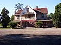
The Van Hoesen House, also known as Kinderhook Station, in 2005.

See also
 In Spanish: Niverville (Nueva York) para niños
