
Noatak, Alaska facts for kids
Quick facts for kids
Noatak
Inupiaq: Nuataaq
|
|
|---|---|

Aerial view of a portion of Noatak village
|
|

Location in Northwest Arctic Borough and the state of Alaska.
|
|
| Country | United States |
| State | Alaska |
| Borough | Northwest Arctic |
| Area | |
| • Total | 16.85 sq mi (43.65 km2) |
| • Land | 16.03 sq mi (41.52 km2) |
| • Water | 0.82 sq mi (2.13 km2) |
| Population
(2020)
|
|
| • Total | 570 |
| • Density | 35.55/sq mi (13.73/km2) |
| Time zone | UTC-9 (Alaska (AKST)) |
| • Summer (DST) | UTC-8 (AKDT) |
| ZIP code |
99761
|
| Area code(s) | 907 |
| FIPS code | 02-54700 |
Noatak (Inupiaq: Nuataaq) is a small community in Alaska, United States. It is known as a census-designated place (CDP). This means it's a specific area identified by the United States Census Bureau for collecting population data. Noatak is located in the Northwest Arctic Borough. In 2020, about 570 people lived there. This was an increase from 514 people in 2010. The community is served by the Noatak Airport.
Contents
History of Noatak

Noatak started as a place for fishing and hunting in the 1800s. Two main groups of Inupiat lived along the Noatak River. The Nautaaġmiut lived further up the river. Their name means "inland river people" in the Inupiaq language. The Napaaqtuġmiut lived downriver, and their name means "people of the trees."
In the early 1900s, missionaries named Robert and Carrie Samms settled in the area. They called the settlement "Noatak." A United States post office was officially opened in Noatak in 1940.
Geography of Noatak
Noatak is found on the west bank of the Noatak River. It is about 81 kilometers (50 miles) north of Kotzebue. The village is also about 102 kilometers (63 miles) north of the Arctic Circle. This means it's in a very cold, northern part of the world.
Noatak village is close to the western edge of the Noatak National Preserve. This preserve is a huge protected area, covering about 6.6 million acres (26,700 square kilometers). Noatak is the only community located along the Noatak River, which is over 400 miles (640 kilometers) long.
The total area of Noatak is about 12.2 square miles (31.6 square kilometers). Most of this area, about 11.6 square miles (30.0 square kilometers), is land. The rest, about 0.7 square miles (1.8 square kilometers), is water.
Who Lives in Noatak?
| Historical population | |||
|---|---|---|---|
| Census | Pop. | %± | |
| 1880 | 400 | — | |
| 1910 | 121 | — | |
| 1920 | 164 | 35.5% | |
| 1930 | 212 | 29.3% | |
| 1940 | 336 | 58.5% | |
| 1950 | 326 | −3.0% | |
| 1960 | 275 | −15.6% | |
| 1970 | 293 | 6.5% | |
| 1980 | 273 | −6.8% | |
| 1990 | 333 | 22.0% | |
| 2000 | 428 | 28.5% | |
| 2010 | 514 | 20.1% | |
| 2020 | 570 | 10.9% | |
| U.S. Decennial Census | |||
Noatak first appeared in the U.S. Census in 1880. At that time, it was called "Noatagamute," and all 400 residents were Inuit people. It was later listed as Noatak in 1910 and has been included in every census since. In 1980, it became a census-designated place (CDP).
In 2000, there were 428 people living in Noatak. Most of the people, about 93.7%, were Native American. About 3.7% were White, and a small number were from other backgrounds.
Many households in Noatak have children. In 2000, about 69% of households had children under 18. The average household had about 4.28 people. The average age of people in Noatak was 23 years old. This shows that Noatak has a relatively young population.
Getting Around Noatak
Noatak has a gravel public airstrip that is 4,000 feet (1,219 meters) long. Most people travel to and from Noatak by air. There are no roads that connect Noatak to other towns or cities.
Within the village and for traveling between nearby communities, people use snowmobiles, all-terrain vehicles (ATVs), and small boats. These are very important for daily life and for activities like hunting and fishing.
Community Facilities
The Napaaqtugmiut School serves the children of Noatak. It is run by the Northwest Arctic Borough School District. The current school building opened in 2008. As of 2017, the school had 177 students. About 95% of these students were Alaska Natives.
Images for kids
-
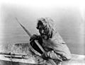
An Inuit man from Noatak

See also
 In Spanish: Noatak (Alaska) para niños
