Noatak River facts for kids
Quick facts for kids Noatak River |
|
|---|---|

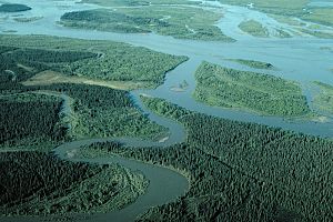
Near the river mouth south of Noatak
|
|
|
Location of the mouth of the Noatak River in Alaska
|
|
| Native name | Nuataam Kuuŋa |
| Country | United States |
| State | Alaska |
| District | Yukon–Koyukuk Census Area, North Slope Borough, Northwest Arctic Borough |
| Physical characteristics | |
| Main source | Schwatka Mountains, Brooks Range Gates of the Arctic National Park, Yukon–Koyukuk Census Area 4,156 ft (1,267 m) 67°22′44″N 154°53′37″W / 67.37889°N 154.89361°W |
| River mouth | Hotham Inlet, Kotzebue Sound, Chukchi Sea 7 miles (11 km) north of Kotzebue, Northwest Arctic Borough 0 ft (0 m) 66°58′53″N 162°30′23″W / 66.98139°N 162.50639°W |
| Length | 425 mi (684 km) |
| Basin features | |
| Basin size | 12,600 sq mi (33,000 km2) |
| Type: | Wild |
| Designated: | December 2, 1980 |
The Noatak River (Iñupiaq: Nuataam Kuuŋa) is a long and wild river in Alaska, a state in the United States. It's known for being one of the largest untouched river systems in North America. The river's name, Nuataam Kuuŋa, comes from the Iñupiaq language, spoken by the native people of the area.
Description
The Noatak River starts high up in the Schwatka Mountains, which are part of the Brooks Range. This area is inside the amazing Gates of the Arctic National Park. From there, the river flows west for about 425 miles (684 km) until it reaches the Chukchi Sea at a place called Kotzebue Sound.
What's really cool about the Noatak River is that its entire journey is north of the Arctic Circle. This means it's in a very cold and remote part of the world!
After leaving Gates of the Arctic National Park, the river enters the Noatak National Preserve. This special preserve protects the entire area that drains into the Noatak River, from its start all the way to near its delta. This makes the Noatak basin the biggest undisturbed river area in the United States. The Noatak National Preserve itself is huge, covering about 6.5 million acres (26,300 km²)!
The only town along the Noatak River is a village also called Noatak. It's a small community with a gravel airstrip, a few stores, a post office, and a school. The river gets its water from a large area around it. Sometimes, if there's a lot of rain, the river can rise quickly and cover parts of the riverbanks that are usually dry.
Name Origin
The name "Noatak" has an interesting history. A surgeon named John Simpson from the Royal Navy called it "Inland River" on a map in 1853. This was likely his way of translating the Inuit name Nunulak. The name Nunatak might also mean "new land" or "belonging to the land."
Wild and Scenic Designation
The Noatak River is so special that a big part of it, about 330 miles (531 km), was given a "Wild and Scenic" designation on December 2, 1980. This means it's part of the National Wild and Scenic Rivers System. This special status helps protect the river and its surroundings, keeping them natural and wild for everyone to enjoy.
See also
 In Spanish: Río Noatak para niños
 | Mary Eliza Mahoney |
 | Susie King Taylor |
 | Ida Gray |
 | Eliza Ann Grier |


