Nord-Est Department facts for kids
Quick facts for kids
Nord-Est
Nòdès
|
|
|---|---|

Nord-Est in Haiti
|
|
| Country | |
| Capital | Fort-Liberté |
| Government | |
| • Type | Departmental Council |
| Area | |
| • Department | 1,622.93 km2 (626.62 sq mi) |
| Population
(2015)
|
|
| • Department | 393,967 |
| • Density | 242.7505/km2 (628.7208/sq mi) |
| • Urban | 190,926 |
| • Rural | 203,041 |
| Time zone | UTC-5 (Eastern) |
| ISO 3166 code | HT-NE |
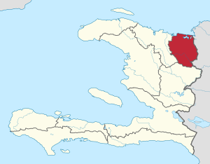
Nord-Est (which means North-East in English) is one of the ten main areas, called departments, in Haiti. It is located in the very northeastern part of the country. This department shares a border with the Dominican Republic. The main city and capital of Nord-Est is Fort-Liberté.
After the Haitian Revolution, Haiti was first divided into only three departments. These were Nord, Ouest, and Sud. The Nord-Est department was originally part of the larger Nord Department.
Contents
Geography of Nord-Est
The Nord-Est department covers an area of about 1,805 square kilometers. It is the second smallest department in Haiti. Only the Nippes department is smaller.
This department has natural borders all around it. To the north, it meets the Atlantic Ocean. The Nord Department is to its west. To the south, it borders the Centre Department. Its eastern side is next to the Dominican Republic.
The most important river in this area is the Dajabón River. It is also known as the Massacre river. This river forms part of the border between the Dominican Republic and Haiti. It flows from the Dominican city of Dajabón all the way to the ocean.
The Massif du Nord is a large mountain range found here. In the Dominican Republic, it is called the Cordillera Central. These mountains stretch from the northwest to the southeast. They run along the southern half of the Nord-Est department.
In the northern part of the department, you will find the Pleine du Nord. This name means "Northern Plain" in English. This area has many savannas, which are wide, flat grasslands.
Population and Main Cities
In a census taken in 2003, the Nord-Est department had 308,385 people living there. Out of these, 150,525 were men and 157,860 were women. About 117,872 people, which is 38.22%, lived in cities and towns. The population density at that time was about 171 people per square kilometer.
The two most important cities in the department are Fort-Liberté and Ouanaminthe. Fort-Liberté is the capital city.
How Nord-Est is Divided
The Nord-Est department is split into smaller areas for easier management. These areas are called arrondissements. Think of them like large districts. There are four arrondissements in Nord-Est.
Each arrondissement is then divided into even smaller areas called communes. These are similar to municipalities or towns. There are 13 communes in total.
Here are the arrondissements and their communes:
- Fort-Liberté
- Fort-Liberté
- Perches
- Ferrier
- Ouanaminthe
- Ouanaminthe
- Capotille
- Mont-Organisé
- Trou-du-Nord
- Trou-du-Nord
- Caracol
- Sainte-Suzanne
- Terrier-Rouge
- Vallières
- Vallières
- Carice
- Mombin-Crochu
Economy of Nord-Est
The main way people make a living in the Nord-Est department is through agriculture. Many very small farms are found here. Farmers grow different crops like beans, peanuts, and maize (corn). In the mountain areas, coffee is an important crop that is grown.
Fishing is also a key activity, especially along the coast. People catch fish and other seafood from the ocean.
Commerce, which means buying and selling goods, is the main activity in the city of Ouanaminthe. This city is a busy place for trade.
|
||||||
| Artibonite • Centre • Grand'Anse • Nippes • Nord • Nord-Est • Nord-Ouest • Ouest • Sud • Sud-Est | ||||||
See also
 In Spanish: Departamento Noreste para niños
 | Chris Smalls |
 | Fred Hampton |
 | Ralph Abernathy |

