North Oxford, Maine facts for kids
Quick facts for kids
North Oxford, Maine
|
|
|---|---|
| Country | United States |
| State | Maine |
| County | Oxford |
| Area | |
| • Total | 546.2 sq mi (1,414.7 km2) |
| • Land | 509.6 sq mi (1,319.9 km2) |
| • Water | 36.6 sq mi (94.8 km2) |
| Elevation | 1,463 ft (446 m) |
| Population
(2020)
|
|
| • Total | 16 |
| • Density | 0.0293/sq mi (0.0113/km2) |
| Time zone | UTC-5 (Eastern (EST)) |
| • Summer (DST) | UTC-4 (EDT) |
| ZIP Codes | |
| Area code(s) | 207 |
| FIPS code | 23-52575 |
| GNIS feature ID | 582634 |
North Oxford is a special kind of area in Oxford County, Maine that doesn't have its own local government. It's located in the state of Maine, United States. In 2020, only 16 people lived there, making it a very small community.
Contents
Exploring North Oxford's Geography
North Oxford is a large area, covering about 546 square miles (1,414 square kilometers). Most of this land, around 510 square miles (1,320 square kilometers), is dry land. The rest, about 36 square miles (95 square kilometers), is water.
This area includes sixteen smaller parts called townships. Some of these are Adamstown, Grafton, and Magalloway. The land here is mostly mountainous, which means there aren't many flat areas. Because of the high elevation, it can get frosty even in June and August. This leaves a very short growing season for plants, only about 60 days long.
The Story of Grafton Township
Grafton was the only township in North Oxford that became an official town. The first European settler, James Brown, arrived in 1834. He built a sawmill in 1838. Some of the workers he hired to cut and mill lumber built homes nearby. These homes were along what is now Maine State Route 26. People also raised some animals and grew crops like hay, oats, and potatoes to feed themselves.
Grafton became an official town in 1852. A school was built, and by 1859, it had 37 students. However, the number of students slowly dropped over time. In 1880, Grafton had its largest population with 115 people.
- Logging in Grafton*
During the winter, about a hundred men would come to Grafton for the logging season. They would cut down trees and then float the logs downstream when the snow melted in spring. Logging became even more intense after 1893. This was when the Success Pond Railroad was completed, connecting Grafton to Berlin, New Hampshire.
By 1907, all the original forests had been cut down, and the railroad was removed. When there were no more logging jobs, most residents sold their land to a paper company and moved away. Grafton stopped being an official town in 1919. Most of the buildings were torn down by the new landowner to prevent fires.
The 1944 B-17 Plane Crash
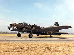
North Oxford was the location of Maine's second-worst military plane crash. On July 11, 1944, a Boeing B-17 Flying Fortress bomber was flying from Nebraska. It was on its way to Dow Field to prepare for a flight across the Atlantic Ocean. The plane was going to join the World War II effort to bomb targets in Europe.
The bomber likely got lost in thunderstorms over North Oxford. These storms might have damaged the plane's radio. Local people heard the bomber flying in circles for over an hour in the cloudy sky. Then, it crashed 500 feet below the top of Deer Mountain. This mountain is in the southeastern part of Parkertown Township. All ten members of the United States Army Air Forces crew died in the crash.
Today, the Deer Mountain crash site has a memorial marker. It is a popular place for hikers to visit. Interestingly, another major plane crash in Maine, the Long Creek Air Tragedy Memorial, happened on the same day, about 100 miles to the south.
North Oxford's Population Changes
| Historical population | |||
|---|---|---|---|
| Census | Pop. | %± | |
| 1970 | 9 | — | |
| 1980 | 37 | 311.1% | |
| 1990 | 11 | −70.3% | |
| 2000 | 17 | 54.5% | |
| 2010 | 24 | 41.2% | |
| 2020 | 16 | −33.3% | |
| U.S. Decennial Census | |||
In the year 2000, there were 17 people living in North Oxford. These people lived in 9 households, and 6 of these were families. The population was mostly White, with a small percentage of people from two or more races.
The people living in North Oxford in 2000 were of different ages. About 6% were under 18, and about 18% were 65 or older. The average age was 57 years old. There were more males than females in the area.
See also
 In Spanish: North Oxford (Maine) para niños
 | James B. Knighten |
 | Azellia White |
 | Willa Brown |


