
Novaya Zemlya facts for kids

Novaya Zemlya (which means New Land in Russian) is a group of islands in the Arctic Ocean. It's located in the far north of Russia, right at the edge of Europe. This archipelago is made up of two main islands: a northern one and a southern one. They are separated by a narrow waterway called the Matochkin Strait.
These islands act like a natural border, dividing the Barents Sea from the Kara Sea. Together, the two islands stretch for about 900 kilometers (about 560 miles). They are quite far north, between 470 and 1150 kilometers (290-715 miles) north of the Arctic Circle.
Today, a small number of people live on Novaya Zemlya, around 2,700 in total. Most of them, about 2,600, live in the main town called Belushya Guba, which is on the southern island.
Contents
A Look Back: Novaya Zemlya's History
People from Novgorod, a city in Russia, knew about Novaya Zemlya a very long time ago. Hunters from this area visited the islands as early as the 11th century.
Exploring Novaya Zemlya's Landscape
Novaya Zemlya is actually the northern part of the Ural Mountains. This means the inside of the islands is very mountainous.
- The northern island has many large areas of ice called glaciers.
- The southern island has a tundra landscape. Tundra is a type of biome where tree growth is stopped by low temperatures and short growing seasons.
A Special Test Site
In July 1954, Novaya Zemlya was chosen to be a special test site. It was used for testing during the time known as the Cold War. In 1961, a very large test was carried out here. This test involved the Tsar Bomba, which was the biggest nuclear device ever created. It was much larger than any similar device made by other countries.
Images for kids
-
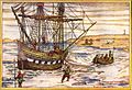
Willem Barentsz' ship among the Arctic ice
-
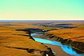
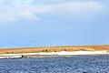
Landscape in Novaya Zemlya, Russian Arctic National Park
-
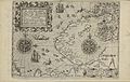
1599–1601 map of Novaya Zemlya
-
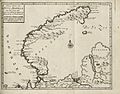
Map of Novaya Zemlya from 1720.
-
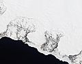
Natural-color satellite image of the Nordenskiöld Glacier group. East coast, Severny
-
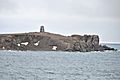
Barents Bay (Willem Barents' gravesite; 76°27’N, 68°42’E)
-
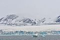
Inostrantsev Glacier terminus (76°28‘N, 66°5‘E)
-
Cape Zhelaniya (Northernmost cape of Severny; 76°57’N, 68°35’E)


See also
 In Spanish: Nueva Zembla para niños
